


IT COMES DOWN TO A QUESTION OF LOVE...
- Dec 9, 2020
- 3 min read
When it comes to weather there has always been a love hate relationship between the northern and southern branches of the jet stream. Sometimes they mingle in a mellow way, other times they independently go their separate ways. And then, there are the times when they come together and love is in the air. That's when the sparks fly and its time to batten down the hatches and get out of the way.

A QUESTION OF LOVE
The issue that's comes to mind this weekend is the amount of love (interaction) that exists between these two branches of the jet...what we call phasing in the weather world. A few days ago models were all in for a healthy romance (an engagement of sorts) that would result in a fairly large wet storm for the upper Midwest with snow and rain all the way into Minnesota and Wisconsin. Now we've had a bit of a spat and at least for now the romance is off.
WHAT'S IT ALL MEAN
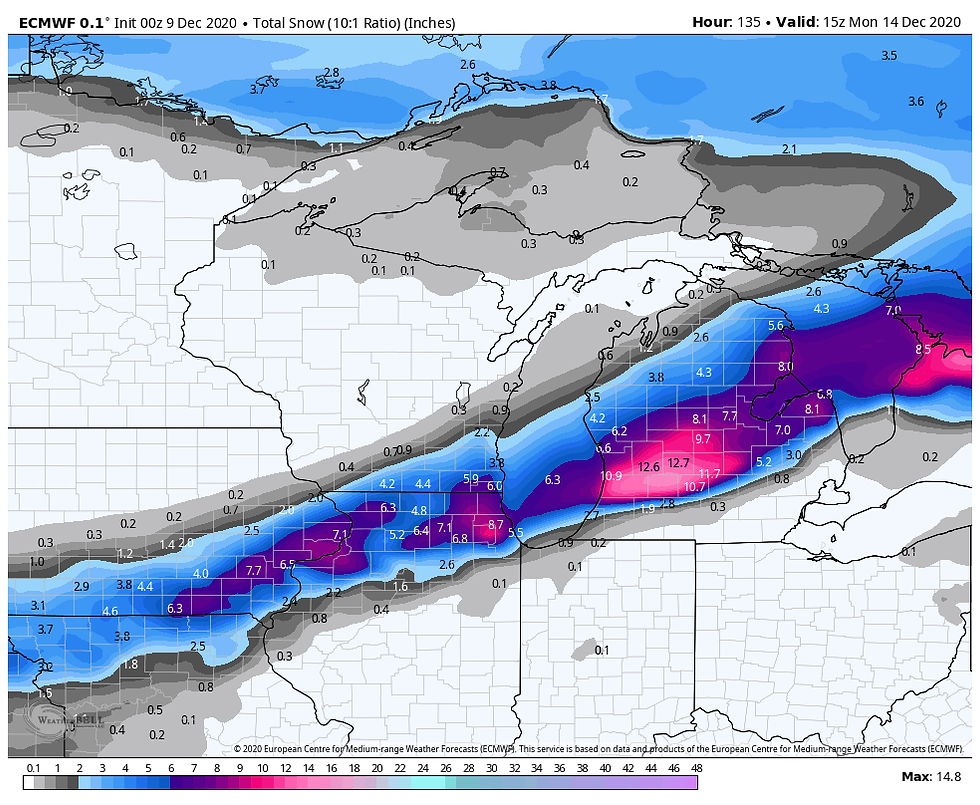
In a meteorological sense, this results in a weaker system with a more southerly track. My northern counties may see little if any precipitation at all as the rain/snow shield is suppressed southward. The other important change is that colder air is allowed to sink just far enough south to bring accumulating snow into play for the SE half of my area.
Before we get to the snow, here's what models are indicating for total precipitation with the sub-tropical (southern branch jet) being the dominant player. If there is one thing the southern branch is noted for, it's the ability to pull precipitation producing moisture northward when it's in play. You can also see the northern fringes if my area remain rain or snow free as high pressure sends dry air into that part of my region.
The EURO

The GFS

Precipitation in my area will likely start as rain Friday and then transition to snow Friday night before tapering off Saturday. The snow band is narrow but certainly could have some impacts if it develops as shown. Here's what the EURO is showing.
The GFS spares SE Iowa and WC Illinois with a warmer solution. That's possible but but this whole scenario looks shaky and low confidence to me. We should bet a much better handle on where this is headed in the next 24-36 HRS.

The key take-away is that we are still 72 hours away from the coming event and things can still change so keep in mind these snow depictions are not forecasts, just model guidance. I suspect snow totals will go down some in future runs, they usually do. The wet nature of the snow will allow it to compact as well. Then there is the issue of the change-over from rain. If that's slower than anticipated that can take a bite out of amounts as well. Lots to figure out in coming days. Roll weather...TS
16 DAYS UNTIL CHRISTMAS, WHAT ARE YOU WAITING FOR, 1,000 PEOPLE CAN'T BE WRONG?

If you've been procrastinating and haven't found the right gift for that special person, there's still time to get my new book Derecho 911, Iowa's Inland Hurricane. We've sold over 1,000 copies but still have one socked away for you. Order by December 14th and get yours by Christmas. It's a thoughtful gift from Santa that will be appreciated by that hard to buy for individual. The book is coffee table style and color with more than 100 pictures, images, and graphics that I guarantee is entertaining, well researched, and very informative. For more info or to obtain your autographed copy please click on derechobook.com


Comments