


IT STARTS WITH A BANG
- Jun 20, 2025
- 4 min read
An intense period of heat and humidity will lock in this weekend, allowing the hottest temperatures of the summer, of which Saturday is the first full day of 2025. Along with the heat will come a rich flow of tropical moisture that will add immense discomfort, allowing heat index temperatures to reach critical levels of 105 degrees or more.

Before the true sizzle sets in, a round of thunderstorms appears possible Friday morning that have the potential to sport gusty winds, perhaps some hail, and heavy rain where the stronger updrafts occur. Looking at the 500mb heights Thursday evening, one can see the incoming heat pushing into Iowa. On the northern periphery, the ring of fire is situated. A short wave (vorticity) is riding the boundary southeast. That, and a strong low level jet, provides the forcing to create and maintain storms late Thursday night into Friday morning before they dissipate.

All things considered, it appears storms that fire upstream will consolidate into an MCS and track towards Iowa. The question is how far east can they get. Dry air is still entrenched over western Illinois, and that is likely to force storms to take the path of least resistance and best instability into NC and EC Iowa. That makes my counties, in Iowa and far NW Illinois (near or west of the Mississippi), more susceptible to storms Friday morning than those to the southeast. Additionally, as the storms progress, the low level jet will diminish as the morning progresses, causing the storms to weaken and quickly dissipate as they get into SE Iowa.
The HRRR does show the circular core of the expected MCS (Mesoscale Convective System) situated over NE Iowa around 7:00 a.m.

The simulated radar of the HRRR shows the strongest reflectivity at that time near Waterloo

The simulated infra-red satellite imagery highlights some cold cloud tops in the darker reds, which would indicate vertical heights capable of updrafts strong enough for scattered strong winds and locally heavy rains.
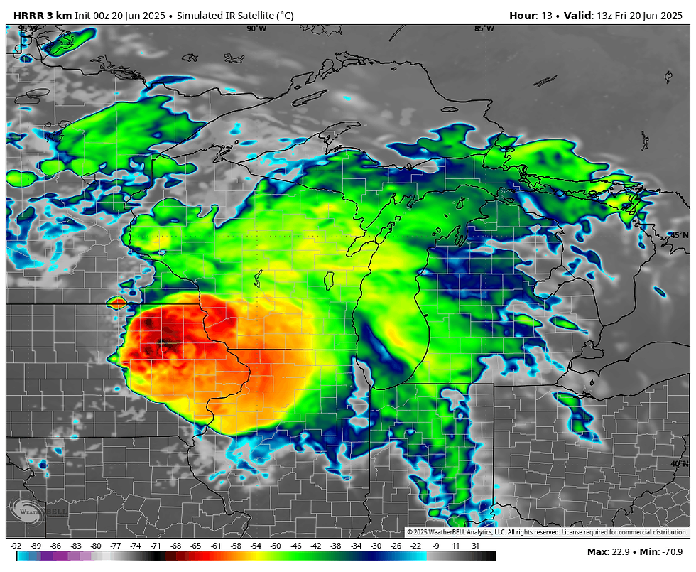
There are some impressive helicity tracks from NW of Cedar Rapids to Waterloo and on to Mason City. That typically points to rotating updrafts (most likely in the mid-levels) capable of severe wind gusts. However, the greatest potential is only found over my far western counties. Thus, the worst of any wind, at least according to the HRRR, stays roughly on (or west) of a line from Vinton and Waterloo to Mason City.

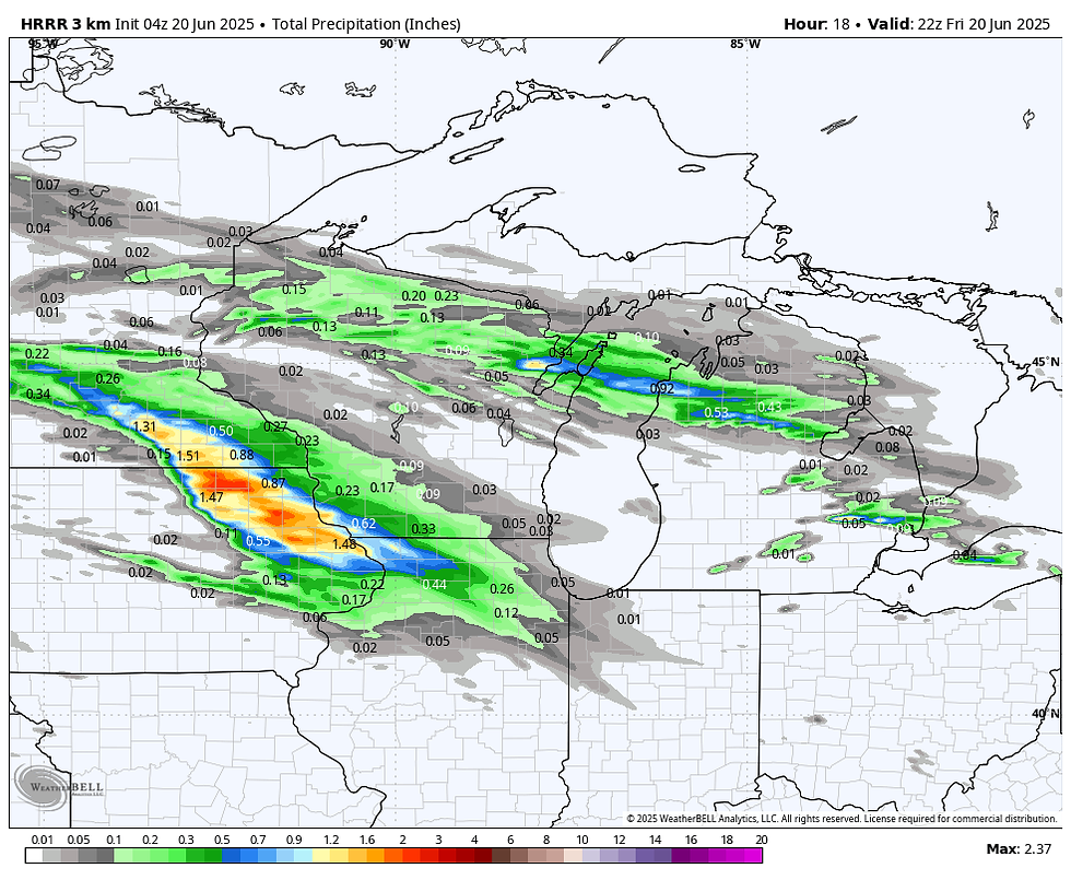
Rainfall is tricky too as the heavy band will be intense but narrow. Additionally, it will weaken as morning unfolds, and how fast that happens determines how long heavy amounts can occur before the whole complex dissipates. Here are some examples of what models are suggesting from any rain Friday morning. The HRRR is by far the most aggressive, with stronger storms and heavier rain. All models show little rain south of I-80 and especially SE of the Quad Cities.
The HRRR
The 3k NAM

The EURO

The GFS

Sunshine will eventually emerge in all areas Friday afternoon, enabling highs of about 85 NE to 90 in the SW.
HOT TEMPS, HOT DEALS AT MY GALENA AIRBNB

My 5-STAR AIRBNB just outside of Galena still has some openings this summer. All of our ratings are 5 star! We take pride in the amenities and the cleanliness. If you book now, we'll take off $200, and we can eliminate AIRBNB fees and additional costs that will save you big bucks. Other discounts apply. Call or text Carolyn at 563-676-3320 for our best deal of summer. See more at https://www.littlewhitechurchgalena.com/
WELCOME TO THE JUNGLE BABY
Friday night, the heat continues to advance northeast as the heat dome expands. At 500mb, (jet stream level) looks like this, with the ridge centered just to the east. The resulting SW flow taps hot air and abundant moisture out of the Gulf of Mexico.

When I say rich moisture, I mean it. The 3K NAM has dew points in the mid 70s over the entire central U.S. A 78 dew point is showing in Dubuque Saturday afternoon.

Along with that, the 3K has widespread temperatures of 94-96.

That combination of heat and humidity, which I would say is the worst case scenario, gets heat index values up to 110. At the very least, 105 looks attainable.

The day with the greatest potential for actual highs reaching 100 is Monday, when the EURO shows the mercury hitting the century mark from about the Quad Cities southwest.

The EURO indicates the heat sticks around for multiple days, maybe most of next week. The EURO meteogram through next Wednesday looks like this. These are straight up temperatures, no heat index factored in.

Assuming this is correct, it's likely going to make it hard for storms to reach my central and southern counties in a highly CAPPED environment after Friday morning through Thursday. With time, the ring of fire should inch a bit further south, especially after Tuesday, which would at least give the north a chance for some storms and some welcome relief. With so much heat and humidity, CAPE (instability) will be healthy, and any place that can tap into that with a storm could certainly see severe weather. It's far too early to even think about timing and placement, though. The National Blend of Models (NBM) through next Thursday clearly shows a classic ring of fire next week that sets up across northern Iowa, Minnesota, and Wisconsin. The NBM depiction is a blend of models, so rest assured there are some that are showing much higher amounts more in the 8–10 inch category in local spots within the band. This could become a problem area for excessive rains, flooding, and flash flooding with time. At least through Thursday, my northern counties are on the southern fringe of the heavy precipitation. Something to watch.

Anyway, this heat wave could begin with a bang in my western counties Friday morning thanks to storms. Then it's full on sunshine and humidity the rest of the weekend into early next week. Welcome to the jungle. Have a solid weekend and roll weather...TS


Comments