


NOT DONE WITH STORMS YET
- Jul 15, 2025
- 4 min read
Before we get to our next chance of storms and what could be pockets of heavy rain, here's a recap on what went on last Thursday and Friday when severe weather and flash floods blasted the region. All told, the NWS indicates that 9 tornadoes touched down (4 were EF1 and 2 reached EF2 status).

The EF2 image below was shot by Jessie Percifield on the outskirts of West Davenport around 5:09. At an RV business, over 15 RVs were blown over, one weighing 25,000 lbs. At least 80 moderate to large trees were snapped or uprooted. The tornado was on the ground for 7 miles with winds up to 120 mph and a maximum width of 500 yards. Thanks to Jessie for the amazing picture!


Aside from tornadoes, a line of storms produced significant wind damage from near Cedar Rapids to the northeast of Dubuque. Gusts of 60-80 mph were common, with some possibly as high as 90 mph.

2 day rain totals from the event were impressive, with widespread totals of 3–5 inches. Some local spots had over 6 inches. 5.76 inches was measured in Dubuque and NW Davenport.

Moline broke the single day rainfall record for July 11th with a total of 2.02 inches.

A flash flood emergency was issued for the Quad Cities where many roads were impassable and vehicles were stalled near Duck Creek in Davenport.

For mid-July this was a pretty high-end event with a substantial number of tornado, thunderstorm, and flash flood warnings. Fortunately, nobody was injured and the NWS did an outstanding job issuing warnings and watches.
PRIME TIME TO VISIT TO MY 5 STAR GALENA AIRBNB

My 5-STAR AIRBNB just outside of Galena still has some openings this summer. All of our ratings are 5 star! We take pride in the amenities and the cleanliness. If you book now, we'll take off $200, and we can eliminate AIRBNB fees and additional costs that will save you big bucks. Other discounts apply. Call or text Carolyn at 563-676-3320 for our best deal of summer. See more at https://www.littlewhitechurchgalena.com/
NEXT STORMS UP...
The next storm up is already showing on GOES satellite imagery. Note the thunderstorms that have fired Monday evening over the Plains. Those are scheduled to arrive here Wednesday.

Ahead of the system Tuesday, warm and very humid air makes another run at the Midwest. It promises to be a dry day, but highs in the mid to upper 80s and dew points in the 70s will make things plenty sticky.
That leads us into Wednesday and what looks to be another set-up for active storms, some potentially strong as well as heavy rain producers. Fortunately, the system looks fairly progressive, which should confine the heavier rains to a smaller window of time.
Before storms develop in the afternoon or evening. Temperatures should spike into the upper 80s north and low 90s south. Ample moisture will be in place, allowing substantial instability ahead of the cool front, and it's forcing. CAPE could go over 3,000 j/kg. setting the stage for active storm development.

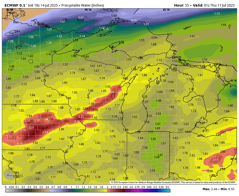
The other thing we don't need for now is more heavy rain. However, as with last week, water vapor is again show exceeding 2 inches ahead of the convergence zone. That is a big signal for heavy rain, where the stronger updrafts materialize.
The 3k NAM is indicating an impressive line of storms progressing across the region later Wednesday afternoon.

The 3k also shows some helicity tracks indicating scattered supercells which would drive a severe threat.

The critical factor in the strength of any storms is the timing of the front and the amount of heating. We should have a better idea of those mesoscale details later Tuesday. As for rain, this is what models are suggesting 48 hours ahead of the event.
The EURO

The 3k NAM

The GFS... Looks a bit on the light side to me.

Any lingering showers exit the SE early Thursday, and the remainder of the day and Friday will be dry and pleasant. Dew points will be falling Thursday and Friday morning are shown reaching the 50s. A refreshing change. Things get hopping again over the weekend.
As Nick Stewart alluded to in his previous post, the region could be in line for another wet period starting Saturday and continuing off and on much of the next 2 weeks. Tropical moisture is looking healthy and with a boundary shown oscillating over the region, that's the classic signal for a ring of fire pattern known for thunderstorm clusters and heavy rain potential. The last 2 runs of the GFS have shown a disturbing trend of excessive rains near or close to the region. It's too early to get caught up in numbers, which are likely significantly inflated. I show them, but only to convey the idea/trend that the long range could be active and wet. Hopefully (and to a significant degree) the GFS backs down considerably in coming days. This is something we will be closely monitoring.
The 18Z GFS show this for rain the next 2 weeks.

The 12Z run (6 hours earlier) showed this.

That will do it for now. Have a solid day and roll weather...TS


Comments