


POTENTIAL TWO-HIT WONDER COLD FRONT
- Jul 14, 2025
- 3 min read

A cold front remains in the forecast for the middle part of the week, and this same boundary may have a double-impact with two chances of rain and storms, the second of which may be influenced by weather originating from Florida. It's a bit of an interesting week of weather that is far from set in stone, but let's talk through this rather interesting setup as it might unfold this week.

Let's start with what we know - the early part of the week around the Quad Cities region will feature hot and humid conditions with temperatures reaching into the mid/upper. Most of the day Monday and Tuesday will be sunny aside from a stray storm that may pop in the afternoon. Convective models are all quiet, but I wouldn't completely rule out an isolated storm.
Wednesday and Thursday are when things get more active. A cold front is likely to swing through the region late Wednesday into Thursday which will likely cause showers and thunderstorms, some could be strong given the instability in place and mediocre wind shear. The European Ensemble has 0.25"-0.50" across the entire region which seems like a decent starting point for potential.
THE EURO

THE GFS

Compared to yesterday the cold front passage appears to be later - later Wednesday evening/night into Thursday morning. This could limit the severe potential locally with the strongest threat focused farther west. That would be ideal given the cleanup ongoing from last week's storms. Both global models do bring storms into the region so we will watch that closely once the higher-resolution models get in range.
THE EURO

THE GFS

As that cold front passes through bringing the rain threat, it likely stalls out near the area as upper-level support breaks down keeping the pattern somewhat stagnant. Where exactly the boundary sets up has pretty big implications on how temperatures and humidity shape up Friday/Saturday. The Euro is farther south with the boundary bringing more comfortable dewpoint values in the 60s areawide while the GFS is farther north. I personally think the Euro has a better handle on this system as of now.
Now that cold front stalling out is very critical to watch as we head to the upcoming weekend and early next week as trouble may be brewing in the tropics, and this could lead to a heavy rain threat locally.

As of Sunday night, the National Hurricane Center has a low chance, 30%, of a tropical system developing over Florida and emerging into the Gulf. Some guidance tonight is a little more bullish with development into a tropical storm making a landfall along the northern Gulf coast. So why am I bringing this up, other than the fact I am a Florida Man?

Whatever happens with this tropical system, it will likely dump a rather large amount of moisture into the central US. The European model shows an elevated plume of precipitable water more than 2.0" surging northward. As that aforementioned cold front is projected to stall out near the area, it could be the lift needed to develop showers and thunderstorms. There are a lot of unknowns at the moment and I would consider this a rather low-confidence forecast for now, but this could become something we will need to watch very closely.

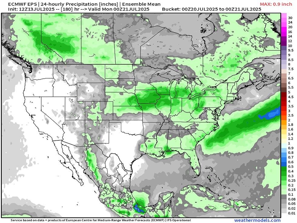
The European Ensemble is indicating some precipitation oriented along this boundary this weekend into early next week. The signal is muted, but it is there for the time being.

The Weather Prediction Center has this boundary stalled out over the region Sunday morning, but they do not necessarily have the potential tropical system in the mix. If the system does develop as I alluded it might, it could change things quite a bit. I think the upcoming weekend could at least have a rain risk whatever happens.

I hope everyone had a great weekend! We had the Cocoa Beach Air Show and it was a stellar event with the F-22 Raptor headlining the show. It's my favorite plane! Have a great week everyone,
-Meteorologist Nick Stewart


Comments