


OUT OF THE GATE FAST...
- Aug 16, 2025
- 5 min read
Not everybody saw them, but for those that did, Friday's storms packed a punch. Strong warm air advection along a warm front triggered a line of storms towards evening that produced winds up to 65 mph and some nickel size hail. Along with that, torrential rains of up to 2 inches fell in spots. The fast moving storms originated in NW Iowa and tracked SE centered on a line from Waterloo to the Quad Cities, largely avoiding my far NE and SW counties. At the time of this satellite image Friday evening, you can see two massive updrafts, one in Iowa and the other near Minneapolis, Mn.

Below the infra-red enhancement shows the towering anvils, some 45 to 50,000 feet high in the dark reds.

An interesting fact is that most models 24 hours earlier had no inkling that storms would make it into eastern Iowa until Saturday at the earliest. The experts at SPC never had anything more than a marginal risk of severe storms in my area until its late morning outlook Friday, when they updated to a slight risk. The storms were driven by a vorticity maxima that emanated from storms in the Plains Thursday night. Models have a tough time seeing these intricate details until the storms develop and mature. I've been talking recently about how these features were going to make for difficult forecasts regarding where storms and heavy rain will form. Additionally, cold pools that are produced by them alter temperatures through outflow boundaries. These can also disrupt instability and the location of storms the next day. Until they happen, models can't account for their existence and that's why it's going to be a day by day challenge to call temperatures and pinpoint the development of additional storms, which will happen in this ring of fire set-up. We are out of the gate fast, with storms already in the bank 24 hours ahead of time.
Typically, with more traditional scenarios, the GFS and EURO are pretty reliable for pinpointing heavy rain potential several days in advance. With MCS (mesoscale convective systems) and their ability to produce MCV (mesoscale convective vorticity), one needs to be very cautious using anything that is not a CAM, a (convective allowing model) like the HRRR or 3K NAM more than 24 hours in advance. In other words, where we positioned with regard to sensible weather makes this a low confidence forecast with many unknown intangibles until further notice.
With that said, some generalizations exist. We do have an active boundary that will be quasi-stationary the next few days. In other words, it moves around only slightly influenced by individual storm clusters. For much of the next 72 hours, we should be close enough to the boundary to see exceptional amounts of moisture and humidity. We will also have the ability to see significant heating south of any effective boundaries. Recent data suggests that at least Saturday, all of my area resides in hot humid air. The NWS is on that and has a heat advisory in effect for heat index values of 100-105 for all but my NE counties. They also mention there is high uncertainty and the heat could be displaced further north or south, dependent on storms, debris clouds, or outflow boundaries. Fresh trends indicate it's possible that the NWS pushes the heat advisories a couple counties NE encapsulating the majority of my area Saturday. At this point, these are the counties under heat advisories.

In terms of modeling, the EURO Saturday has heat index values over 100 all the way into SW Wisconsin.

The GFS, appears comparable.

The 3K NAM, which theoretically should be best since it's a CAM (convective allowing model) shows little in the way of storms Saturday. As a result, it allows the heat to fight north, and it now shows heat index values of 100 to 108 areawide. I'm leaning on it, and it looks to be a mean day for steamy weather throughout my region.

Sunday and Monday, with the quasi-stationary front extending from NW to SE, somewhere over NE or EC Iowa it becomes a day by day process to refine the northern extent of the heat, but it sure looks like my southern counties have a good chance of getting seared 3 more consecutive days. The north, closer to storm outflow, may
catch a break from what is seen Saturday. Again, small mesocale details yet to be determined will determine the verdict.
As for rain going forward, about all you can do is broad brush the fact that instability will be huge and thunderstorms will be possible, especially over the northeast half where the atmosphere will be less susceptible to CAPPING (warm air aloft that thwarts storm development).
Saturday appears to largely be a steamy storm free of storms. That generates exceptional instability. By evening the 3K NAM supports that idea with CAPE approaching 5,000 j/kg.

The supercell composite is shown to reach 35 just NW of Dubuque. That's big potential for strong storms in the north Saturday evening.

To that point, a robust line of storms is shown erupting Saturday evening and building SW as the boundary gets forced that way due to storm outflow. Severe storms with strong winds would be a real possibility. It's also possible that the storms could form several hours earlier in the late afternoon than what's currently depicted.

Additionally, water vapor is roughly 99% of climatology, which ensures storms are going to be efficient rain producers. Hopefully, they are progressive, as rainfall rates of 1–2 inches per hour are quite likely if this scenario pans out.
More storms will fire somewhere Sunday and Monday. However, as I've stated several times, until we know where the previous day's event sets up, it's very difficult to put down a bullseye other than it will be close to that vacillating boundary. As far as rainfall goes, I hesitate to even put out model QPF, but the two that I think have the best chance of panning out are the 3k NAM and the EURO. Take their output with a grain of salt, but there is a clear emphasis for the heavier rain potential to be centered on my northern counties.
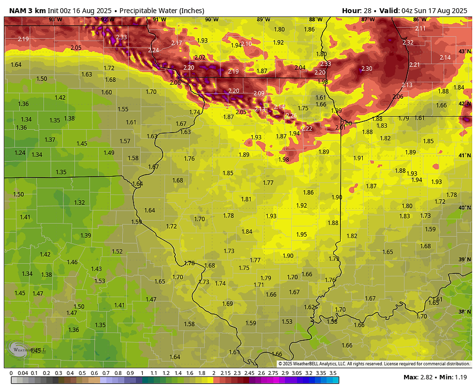
The 3k NAM

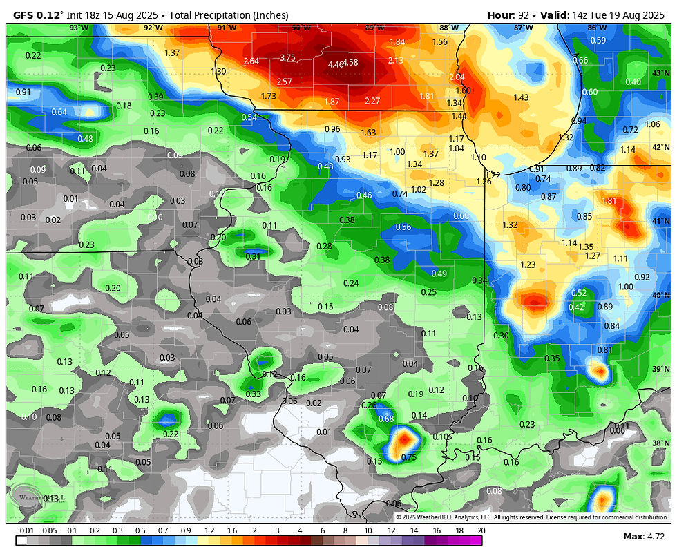
The GFS
To sum it up, if the boundary remains north, and we keep the majority of the storms further north, we are in for 3 days of stifling weather, but at least it will be quiet. If not, some areas, especially the NE, have the potential for 1–3 inches of rain and there would likely be less in the way of heat. In all honesty, that's the best I can do at this point with this seriously hot mess. Have a stellar weekend and roll weather...TS
PLAN A VISIT TO MY 5 STAR GALENA AIRBNB

My 5-STAR AIRBNB just outside of Galena still has some openings this summer. All of our ratings are 5 star! We take pride in the amenities and the cleanliness. If you book now, we'll take off $200, and we can eliminate AIRBNB fees and additional costs that will save you big bucks. Other discounts apply. Call or text Carolyn at 563-676-3320 for our best deal of summer. See more at https://www.littlewhitechurchgalena.com/
1


Comments