


POWERFUL STORMS...
- May 21, 2024
- 4 min read
SIGNIFICANT SEVERE WEATHER THREAT TUESDAY
It remains to be seen how it all plays out, but the potential is high for at least scattered strong storms later Tuesday. High winds and several strong tornadoes are possible over all of my area and much of the central Midwest. The Storm Prediction Center has issued a moderate risk outlook for tornadoes and hurricane force winds if ingredients come together as indicted.
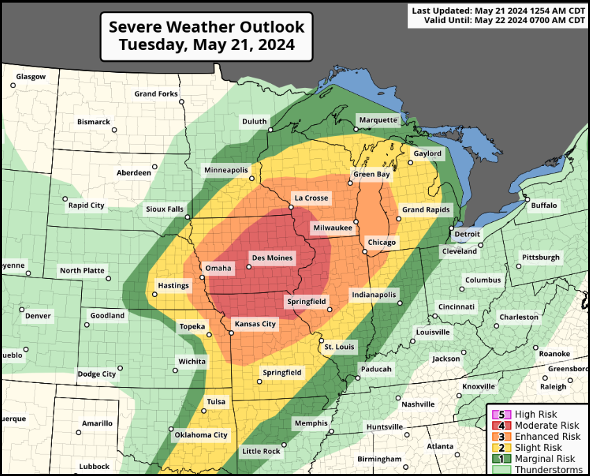
For those wondering, a moderate risk means widespread severe storms are likely. They would have the ability to be long-lived, widespread, and intense. It's a level 4 out of 5 risk as determined by the Storm Prediction Center.

The Quad City NWS office is anticipating storms in the morning, then a break before the much stronger supercells arrive late afternoon and evening. All modes of severe weather are likely, with gusts up to 90 mph and several tornadoes possible in the level 4 moderate risk zone. Having said that, despite the evidence on paper, there are no guarantees the atmosphere ends up doing what the models indicate.
PROBABILITIES OF SEVERE WEATHER TYPES
The pink regions below indicate a 15-29 percent chance of a tornado within 25 miles of a point, with the hatching indicating at least a 10 percent chance of a strong EF2 or greater tornado.

The magenta colors covering my region indicate a 45-59 percent chance of winds 60 mph or greater within 25 miles of a point. Additionally, any spot in my area has at least a 10 percent chance of winds greater than 74 miles per hour (hurricane force).

Last but not least, most of my area has a 30-44 percent of hail large enough to damage cars within 25 miles of a point. Additionally, there is a 10 percent chance that hail could reach 2 inches or more within a given point.

When it comes to set-ups, this is a classic one across eastern Iowa and far western Illinois at a time when the region is entering the peak of the severe weather season. This is a day when watches and warnings are to be expected. Have a plan in place to receive them and respond properly if necessary.
Scattered storms are likely to be ongoing in parts of the area during the morning Tuesday, especially over the NW half. While a couple could be strong, the main event is not fully expected until late afternoon. By that time, quick air mass recovery is expected with temperatures shown in the low to mid 80s with dew points in the upper 60s, perhaps 70. That brings instability (CAPE), to high levels of 2,500 to 3,200 jkg.

With the highly dynamic system plowing into the instability, rapid destabilization if the air mass is expected near and south of the warm front in the warm sector. Very stout mid level winds and low level jet, will promote the development of supercells when storms initiate. Convective allowing models indicate low level bulk shear of up to 40kts near the surface (0-1 km). This creates large curved homographs favorable for tornadoes. The lower the shear in the mesocyclone, the better the odds of getting tornadoes to the ground. More than that, it's the type of structure that could produce strong tornadoes, EF2 or greater. The significant tornado parameters are maxed out during late afternoon over much of central and eastern Iowa. That indicates rotating thunderstorms (supercells) are likely when convection fires.

Eventually, a broken line of supercells is expected to coalesce and form more of a solid line of storms when a potent cold front streaks east towards early evening. This could very well set up a fast moving QLCS (quasi linear, convective system). If this line takes shape, this is when 60-80+ mph winds would become a possibility. Even with the linear structure, 0-3 shear is still substantial, leading to potential tornado spin-ups along the line. These types of QLCS tornadoes are usually weaker and short-lived, but they can still produce damage.
It should also be noted that storms are expected to move rapidly, especially once a cold pool is formed behind the line, enhancing the rear quadrant jet. Storm speeds of up to 50mph are anticipated.
No doubt the stronger updrafts are going to put out some downpours. However, unless you are one who gets repeated rounds of storms, widespread heavy rains may not be an issue. However, there will be places where and inch or two could occur. The NW, closer to the warm front, will certainly be favored for the heavier amounts.
The EURO

The GFS

The 3k NAM

The HRRR

Very gusty winds can be expected Tuesday into Wednesday, with gusts outside thunderstorms Tuesday afternoon and night reaching over 40 mph in spots. Much cooler, drier, and less humid conditions will follow Wednesday with highs back down to the upper 60s and low 70s. More showers and storms are anticipated Friday.
Myself, I will be in the field Tuesday chasing what comes my way. I will do my best to get some images up on Facebook if things materialize where I end up in eastern Iowa. More to come.... Until then, roll weather...TS.


Dubai Chambers of Commerce is dedicated to ensuring you benefit from expert advice, specialised training, global networking events, and practical support platforms.
CSR initiatives in dubai
dubai business mentorship
Business Advocacy UAE
family business governance dubai