RAIN, RAIN, GO AWAY
- Aug 12, 2025
- 3 min read
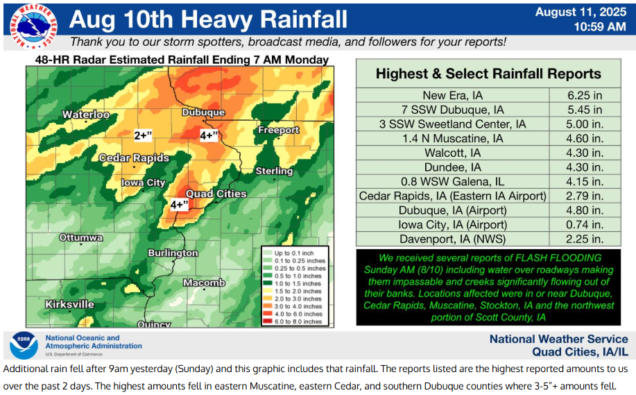
Another big rain event soaked many parts of the Midwest over the weekend. While some parts of my area had over 6 inches of rain, we got out of it better than our friends in southeast Wisconsin. Milwaukee Timmerman Airport measured 14.50 inches. If confirmed by the National Weather Service, that would set the all-time Wisconsin state record for rain, surpassing the previous record of 11.92 inches set in Mellen, a town in northern Wisconsin, in 1946.

In my area, weekend rains were most significant from the Quad Cities northwest, with the highest totals falling in an arc that included parts of, Muscatine, Cedar, and Dubuque counties. New Era, Iowa (NE of Muscatine) picked up 6.25 inches for the most in my area.

Dubuque received 4.90 inches which is the 6th largest single day rainfall event in its history going back to 1873.

The way this event played out, very little rain fell in WC Illinois where amounts were as low as 3/10th of an inch.

As with several previous heavy rain producing systems, the most concentrated band of heavy rain was found from SE Nebraska, through central and EC Iowa into southern Wisconsin.

PLAN A VISIT TO MY 5 STAR GALENA AIRBNB
My 5-STAR AIRBNB just outside of Galena still has some openings this summer. All of our ratings are 5 star! We take pride in the amenities and the cleanliness. If you book now, we'll take off $200, and we can eliminate AIRBNB fees and additional costs that will save you big bucks. Other discounts apply. Call or text Carolyn at 563-676-3320 for our best deal of summer. See more at https://www.littlewhitechurchgalena.com/
RAIN, RAIN, GO AWAY...
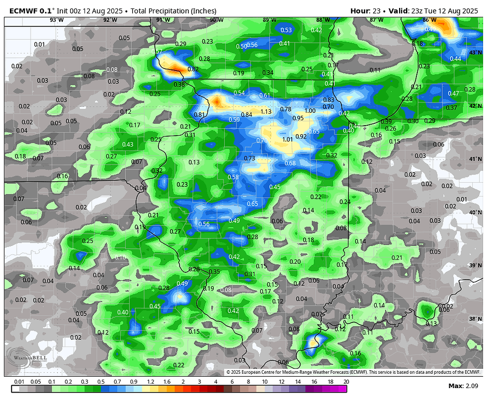
I'm happy to report that an advancing cold front brings an end to the rains later Tuesday. However, scattered showers and storms that developed overnight could fester before ending from west to east as the day progresses. By the time they exit, it's likely some additional heavy rains will fall. That said, coverage of the higher 1" amounts looks to be lower than with recent events. Additionally, the SE half of my area has a better chance of getting into the more significant downpours. Here's what models are suggesting for rain totals through the day Tuesday. Notice the hit-and-miss nature of the rain bands and how that significantly alters totals from one spot to the next.
The HRRR

The 3k NAM

The GFS

The EURO

Tuesday night, the shortwave responsible for the rain departs. This allows NW flow to develop, which finally scours out the deep moisture necessary for rain production. High pressure gets established that lowers humidity and brings rain free conditions Wednesday through Saturday. Dew points, which have been in the mid 70s for several days, should plunge into the low 50s in spots Wednesday afternoon. That will be very noticeable and appreciated by all.

With drier air and the addition of sunshine, temperatures will be seasonal and while warm during the day will actually be quite pleasant at night. Some upper 50s are possible Thursday morning.
Temperatures will continue comfortable through Friday but take an upward turn again Saturday with a rapid return of heat and humidity. Highs may approach or slightly exceed 90 Saturday and Sunday. By then we should be back in an active pattern induced by the proximity of the ring of fire. It's possible another round of wet weather could be the end result. Sunday into Tuesday looks to be the time frame to watch. Mesocale details still unknown will determine the strength and location of any additional heavy rain.
Once Tuesday is behind us, we have until Saturday night at the earliest to dry out. Boy, do we ever deserve it! Roll weather...TS


Comments