


REGIONAL SEVERE THREAT BREWING
- Mar 9
- 3 min read

A rather classic severe weather event continues to take shape across the region on Tuesday with all modeling continuing to show the threat for severe weather including the risk for tornadoes, large hail and damaging wind gusts. The HRRR (above) indicates explosive thunderstorm development along the warm front across southeast Iowa and central Illinois in the late afternoon and evening Tuesday.

The RRFS above indicates a similar solution and are most likely to receive storms. The signal likely keeps the main threat to the south and southeast of the Quad Cities for now, but this will need to continue to be watched for potential trends west and northwest. Given the severe threat will be mainly along and to the south of the warm front, just how far it gets north will indicate the northern extent of the threat.

The dewpoint chart Tuesday keeps that warm front about as far north as I-80 which is rather classic for a severe weather threat this season. Notice the warm dews in the 60s roughly Burlington, Iowa to Kankakee, Illinois. North of this front will feature rather strong northeasterlies out of the Great Lakes - a cold wind off the water which likely will keep the warm front from pushing too far north.
HISTORICAL ANALOGS


Some of the top analogs, or historical severe weather days that have similarities to Tuesday, indicate a rather volatile environment based on the severe weather reports from those days. February 28, 2017 (top) and March 8, 2009 (bottom) are two of the top analogs. Again, the placement of that warm front will dictate just how far north the severe threat materializes. The 2017 event I actually chased, catching that tornado in west-central Illinois. The severe treat in these analogs have a limited impact on our area in eastern Iowa and northern Illinois.

Looking at the top 15 analogs the probabilities of tornadoes are shown above. While not too high, there is a sign that tornadoes are possible with the severe weather forecast Tuesday. The higher probabilities are across western Illinois and farther south to the St. Louis area. Close enough to continue to watch for trends, but far enough that it might just miss us.

The frigid waters of Lake Michigan are a large part of what will keep that warm front in check. Current Lake Michigan water temperatures are in the mid 30s. Strong northeasterlies over this frigid water will modify the air and prevent the warm front from surging northward. This might, in fact, intensify the strength of the warm front and the baroclinic instability along it. Any supercell that can potentially form, and ride along this warm front, will certainly be a potential major severe threat Tuesday.
RECORD WARMTH
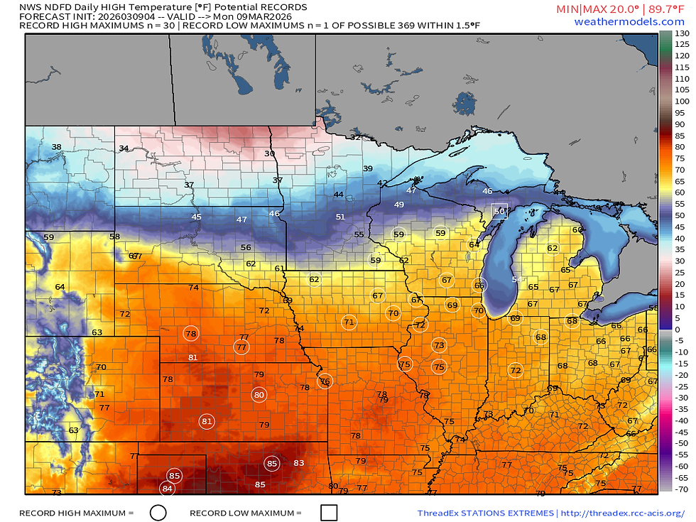
Monday remains a record-warm day across the Midwest with highs expected to surge into the 70s. All the circled cities above indicate a potential record high Monday. Waterloo to Cedar Rapids and over to the Quad Cities are all in play.

A big range in temperatures is forecast Tuesday across the region, the day of the severe weather risk, with the Quad Cities once again in striking distance of a record. Personally, I am not too confident in the warmth getting this far north given the warm front considerations above, but based on the blended model approach it's possible. It will be close!

By Wednesday however the fun is over and reality settles back in. Much cooler temperatures return sending highs back in to the 40s as strong northwest flow returns driving in colder air. Cool temperatures will persist into next week relative to normal.
LONG TERM OUTLOOK

Looking longer term I want to at least touch on the late week and weekend festivities and it appears a rather active storm track is setting up over the region. With the colder air in place the threat for snow is also there, although at this time it looks like the greatest risk for accumulating snow is to the north, especially north of the Iowa/Minnesota border.
In fact, some modeling is starting to indicate some potentially higher snowfall amounts to the north over the next two weeks. While this may not hit is directly, as it stands now, this heavier snow at the headwaters of the rivers in March is always a bit of a red flag for potential river flooding concerns our direction come April. It's just a watch item for now!
Have a great week, everyone!
-Meteorologist Nick Stewart


Comments