ROCK 'EM SOCK 'EM PATTERN...
Well, boys and girls, it's rock 'em sock 'em robots as the EURO and GFS fight it out in what will be an active and challenging weather pattern the next 6 days. I see three systems with the potential to produce accumulating snow but as I often say the devil is in the details You have to be over 6 years old to get into this forecast fight!

The fun begins this weekend and I'll get into the battle to find the truth below. But first this word.
A SECOND PRINTING OF MY NEW BOOK IS COMING...
250 NEW COPIES OF DERECHO 911, IOWA'S INLAND HURRICANE ARE AVAILABLE. Around Christmas we sold the last of the 1500 copies of our book on this historic thunderstorm, the most damaging in U.S. history. Due to continued demand we have ordered a limited number of 250 for those of you interested in having the most authoritative account of this extreme event. You can get yours at derechobook.com
CHILLING OUT
The next 48 hours (Friday-Saturday) will be spent chilling out. An Arctic high pressure will send a strong cold front southward resulting in temperatures to start the day Friday that are at least 25 degrees colder than 24 hours earlier. That means morning readings in the range of 3 to 9 degrees accompanied by wind chills of (-5 to +5) all day long across my area.

Temperatures won't go up much during the day staying generally in the low to mid teens where there is still a generous snow cover. Friday night as winds subside and skies remain fair much of the night, readings will slip below zero north of I-80 for what is expected to be the coldest night of winter so far. Fortunately no wind chill to speak of.

SO WHAT'S THIS I HEAR ABOUT SNOW?
The threat of snow around the area gets real with a 500mb storm track that looks like this into early next week. Note the big mean trough anchored over the west. That places the Midwest in the fight zone with a strong baroclinic boundary (warm air vs. cold air) in place. Vorticity (energy) gets sling shot out of the trough creating what looks to be 3 periods of potential snow.

THE FIRST WAVE
The first wave (generally more of a warm advection event) is driven by return flow Saturday night and early Sunday. There are differences in the amount of forcing and mid level dry air that gets into the SE half of my area which reduces accumulations there. The further NW you go the colder it will be and there snow rations will be more than the traditional 10:1 average yielding higher amounts. Thus, I have used the Kuchera snowfall forecasts which takes that into consideration. Here's what I'm showing for totals from the first system. Keep in mind it is still early and this is raw data, not a hard forecast. Most of my area has the potential for amounts in the 1-4" range with the best chances for 2 inch plus totals northwest of a line from Iowa City to Clinton and DeKalb. Still time for that to change a bit.
The EURO

The GFS

The GEM

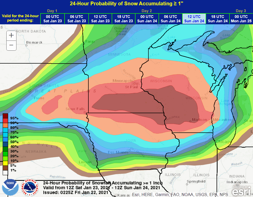
These are the odds of at least an inch of snow from the Weather Prediction Center from wave 1.

The NWS in Des Moines is showing these potential totals.

WAVE NUMBER TWO
Wave two has been giving models (and me) fits for a couple days. Yesterday the EURO was showing more than a foot of snow for much of my area north of I-80 Sunday night and Monday while the the GFS and Canadian had nothing with the storm passing safely to the south. So what's changed? For one, the EURO still has the storm, (but very important) it's been shifting it slightly further south with every single run. This is what it showed last night with snow from wave 1 and 2 combined at a 10:1 ratio.

This is the latest run which combines wave 1 and 2. In the shift southward Waterloo went from 15.2" to 2.6" and Galesburg from 1.4 to 9.5"

This tells me the EURO is having troubles and making corrections. It also worries me that it is still catching up and slight adjustments further south are still possible which would eliminate all but the southern half of my area from the snow wave 2 produces. That also implies the GFS and Canadian are handling the energy better and so far are ahead in this part of the fight.
Having said that, here are what they are showing in their latest runs.
The GFS

The Canadian GEM

Needless to say confidence in the placement of snow with wave 2 is still low to moderate but no doubt there is a solid trend towards keeping the heavier snows with it near and south of HWY 30 . Another 24 hours should bring a much more consistent look among models as data gets better sampled.
ONE MORE FOR THE ROAD ) WAVE 3
Last but not least is wave 3 which is not a player until Wednesday. With the energetic pattern preceding the system I don't think it's worth putting much into snow amounts this early other than to say amounts look light, worst case an inch or two. Plenty of time to cross that bridge. With that I I'm headed to bed eager to see where the road leads us going forward. Nothing like a rock 'em sock 'em pattern. Roll weather...TS


