


FROM TOO MUCH TO NOT MUCH AT ALL

We started off spring with multiple rounds of heavy rain and severe weather mixed in, however the forecast in the short term, in addition to longer-term trends, looks quite dry across the region heading into June. Above, the official forecast from the Weather Prediction Center shows little if any rain over eastern Iowa, northern Illinois and southern Wisconsin over the next seven days.
RRFS - Wednesday/Thursday AM Rain

Euro - Wednesday/Thursday AM Rain
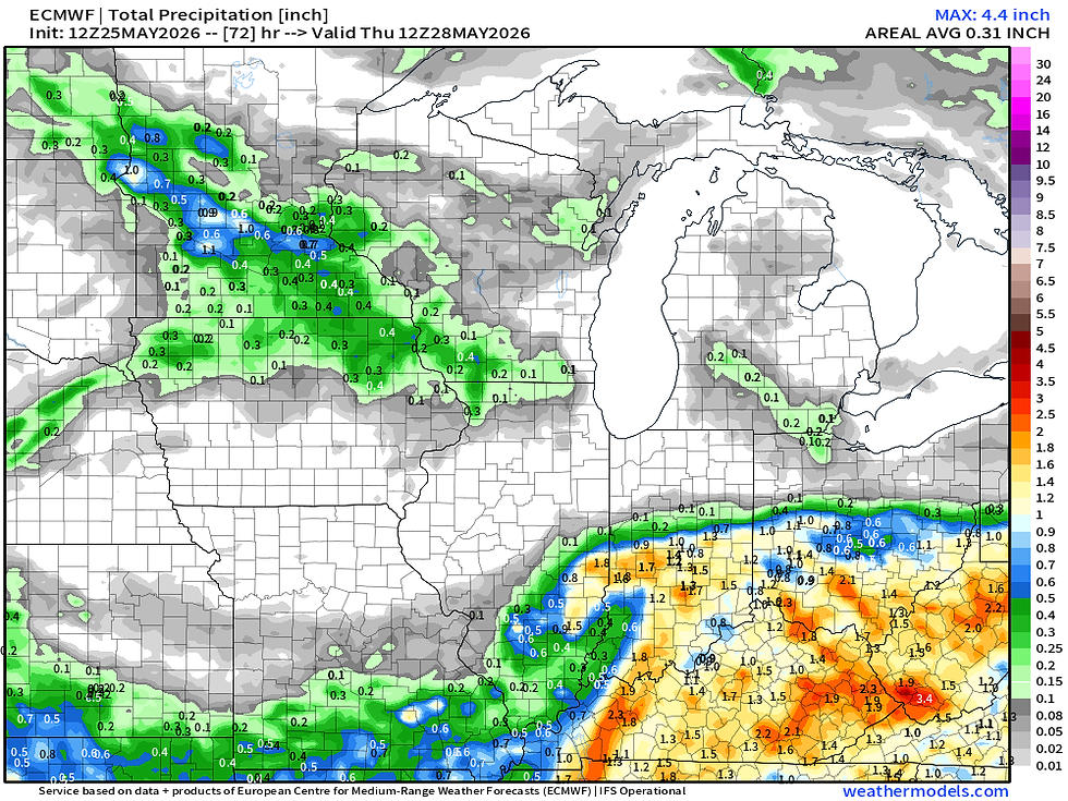
Wednesday looks like the best chance for rain locally, and that may just clip northeast Iowa. The global models like the Euro and the GFS are more bullish with rain than the higher-resolution modeling including the RRFS. I do think lesser totals are likely at this point, but that will be a trend to watch during the week.
Either way, the rain would not be expected to amount to much at this point.

Since the start of meteorological spring we are running on the wetter side of life thus far. East-central Iowa is in the top 16% of historical record with northwest Illinois in the top 10%. I expect these numbers to start changing quite quickly as we step forward another week as limited rainfall is anticipated.
I did some digging and found some rather interesting data which is why this post is a little later than I planned. The Quad Cities at KMLI was in the 10th percentile for rainfall in April-March. Basically in the top 16 years of record.
Of those 16 years that were in the top 10 percent of March/April rainfall, only six have had a below-normal June in terms of rainfall. That, so me, is rather striking.
The years that matched were:
1920
1964
1965
1991
2006
2024
For those inquisitive minds, it was an even split of 2 El Nino, 2 La Nina and 2 Neutral years.

The reason for that is June is our wettest month of the year. Looking at the climate normals for the Quad Cities, June averages about 5" of rain for the month which is 13% of the entire year's precipitation. If you have a pretty big lag in rainfall in June that can set a really bad tone heading into the rest of summer.

Looking at those six years that had a very wet April/May and a below-normal June, two of those years suffered significantly through the rest of summer (1920 and 1991). Worth noting 1991 was also a strong El Nino year. On the other end of the coin, 1965 (the other El Nino year) actually had a very wet rest of the summer and autumn.
Of the six analogs I am looking at, 4 were below normal for the rest of the year, one was near-normal and one was above normal. I did not know what to expect to get out of looking through all the data, but for the six analogs, there's not really a clear signal one way or the other what to expect for now. So, let's go back to the forecast modeling.

Analogs maintain a very high probability of below-normal precipitation through the next week.

In fact, the signal for below-normal precipitation carries all the way into June 8, two week from now. If that maintains itself we could have some pretty rapid growth of drought across the Upper Midwest despite the very wet start to spring.

Looking very long term at some of the seasonal models, the European weeklies actually keep below-normal precipitation across the state of Iowa through Independence Day with the storm track remaining to the south/southeast. This could have some pretty big implications on farmers and crop commodities given the corn belt as a whole is looking somewhat dry.
To wrap this all up, it looks pretty dry over the next 1-2 weeks across the region, and longer term patterns are continuing a dry signal potentially to July.
-Meteorologist Nick Stewart


Comments