


SEARCHING FOR TIME TO DRY OUT
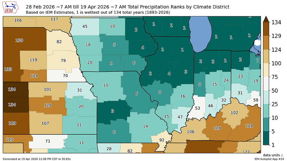
Needless to say it has been a very active stretch of weather across the area so far this spring. Since 1893 it's in the top five for wettest springs to date, with northern Illinois and southern Wisconsin the wettest on record. Rivers are in flood stage and running well above normal. The pattern continues to look active weather over the next 10 days but there are some signals for a break come early May.

The Quad Cities are in the midst of the seventh-wettest spring to date running 3.53" above normal.

Cedar Rapids is the 10th-wettest spring to date running more than 2.5" above normal.

We are watching our next storm system Thursday/Friday which will likely bring more locally heavy rain and a chance of strong to severe thunderstorms. This looks a bit more progressive, or quicker moving, so it likely will not be a significant rain maker, but the overlap of wind shear and instability sets it up for another round of severe weather.

Instability looks modest, but sufficient, for organized strong storms. The latest Euro has storms arriving fairly late Thursday into Friday morning which could additionally limit the severe threat. Lots of time for these details to be worked out with time.

The rain forecast for this event tops out near 1" based on official guidance from the Weather Prediction Center which is well in line with the European Ensemble. Again, not enough to cause major concerns but certainly enough to prolong the ongoing water issues we have in the area.

Looking long term there are some signals the pattern may take a bit of a break. The 500mb chart for May 1 has strong northwest flow over the Great Lakes which would facilitate drier and cooler air moving into the region. This may be enough to at least give us a break from the really active weather pattern we've been stuck in.

The European Ensemble has a pretty strong signal for below-normal precipitation by May 4 across the Upper Midwest. We just need to get through the next 10 days and guidance is slowly starting to indicate some dry time.
Have a great week!
-Meteorologist Nick Stewart


Comments