SO MUCH FOR THE HEAT...
- Sep 6, 2023
- 3 min read
Warm sticky weather was with us Tuesday but it could have been worse were it not for the clouds which hung around until late afternoon. That limited the amount of sunshine and tempered the heat. Highs in most areas remained in the upper 80s, at least 5-6 degrees cooler than what was anticipated. Not only that, a few showers were noted in the southeast. Unfortunately, most were light and brief and didn't settle the dust, which has grown substantial in recent weeks. However, a few lucky spots did see up to a 1/4 inch, mainly near and south of HWY 34. Southeast Jackson County in Iowa also had a small pocket of heavier showers. Here's the Doppler rainfall estimates through early Tuesday evening.

Overnight, some new development took place along a cold front that is in the process of clearing the area. Most of the showers and storms with it were confined to my northern counties on a HWY 20 line from near Waterloo to just east of Dubuque. A small 25 mile band with totals of 1/2 to 1 inch likely occurred. The rest of the area was left high and dry with little if any improvement in the expanding drought conditions.
I noticed in the latest USDA crop report that corn condition in Iowa declined 5 percentage points last week to 49 percent good to excellent. Soybean condition fell 4 percentage points to 49 percent good to excellent. Justin Glisan, the Iowa State Climatologist indicated that last week Iowa experienced its driest reporting period of the season with only a few stations observing measurable amounts. Extreme Drought (D3) now covers 18% of Iowa, the largest extent since Spring 2013.
In the 3 districts (in yellow) that represent my counties in the eastern third of Iowa, topsoil and subsoil moisture is generally more than 50 percent "very short". Not a single region has a surplus in either category and that's pretty much the case for the entire state.

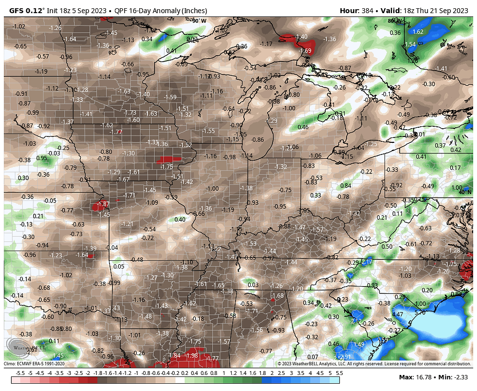
Rain is very much a needed commodity before the cold of winter sets in but prospects continue to look unfavorable for anything widespread or generous. These are the rainfall departures the GFS and EURO depict for the next 2 weeks.
The GFS

The EURO

With the front through, dry air returns to the Midwest Wednesday. While a spotty shower or sprinkle is possible, the next real chance of rain now does not appear to be until Sunday night or Monday. It doesn't look like much either. It's easy to see why prospects are so low by looking at dew points. They are expected to fall into the 50s Wednesday afternoon and Saturday afternoon are shown in the 30s in spots...(yesterday we were in the low 70s). Bone dry air is coming.

For kicks, these are the projected humidity levels Saturday's dew points would support...15-20 percent!

The good news in this coming pattern is that while it will be dry, it won't be hot. The Climate Prediction Center shows well below normal temperatures in the 6-10 day outlook. We'll already be feeling the love Wednesday and it only gets better.

Thursday through Saturday highs will generally be in the mid to upper 70s and with sunshine and humidity free air, we are in line for some sweet September conditions. Bring it on and roll weather...TS
A SPECIAL DEAL FOR TSWAILS USERS, (BUY 2 NIGHTS, GET THE 3RD FREE)
NOW THIS IS "SPECIAL"
Hey everybody! I've got some openings the next few weeks at my AIRBNB, The Little White Church of Galena. I would like to fill it up and that means I'm willing to deal. Contact us direct and we can eliminate the AIRBNB fees and taxes. That means big savings for you. Weekday rates are especially good. ASK ABOUT OUR BUY 2 NIGHTS, GET THE 3RD NIGHT FREE DEAL. The newly remodeled church includes 3 bedrooms, 4 HD TV's, high speed internet, all in a beautiful country setting. All of our reviews are 5 STAR. There's no better time to enjoy Galena and all it has to offer. Split the cost with friends and family and we'll set you up with a deal that's as good as it gets. Call or text Carolyn at 563-676-3320 or email carolynswettstone@yahoo.com We would be thrilled to have you as guests!


Comments