


SOME "SPRING" IN OUR STEP...
- Feb 5
- 4 min read
THE FUTURE DEPENDS ON YOU. IF I DO NOT REACH MY FUND-RAISING GOAL THIS WILL BE THE LAST YEAR OF THE SITE...

As you know, TSwails.com is a no-pay site, existing on voluntary personal donations. Every year I ask those of you who find value in the site to make a financial donation you feel is worthy. Please reflect on the number of times you have visited us in the last year. If the information or knowledge you gained was valuable, it's my sincere hope you will join the loyal group of contributors that's kept TSwails.com operational since 2013. I'm suggesting $20.00, which is roughly 4 cents a day. Less than 4% of my readers donate, so your gift, no matter the size, is not only appreciated; it helps immensely.
PLEASE CLICK HERE TO DONATE 56% TO MY GOAL
In the weather world, things can change and do so dramatically in a day's time. We were on cruise control the first half of January, and then the jig was up when the jet buckled, changing the source region of our air masses. Since January 15th, 19 of the past 21 days in Dubuque, high temperatures have been below normal. One day by as much as 32 degrees.

The last time highs in Dubuque (which is where I happen to live) were above 32 degrees was 19 days ago. At last check, that was over 460 consecutive hours without reaching the freezing mark.

I've been pushing the idea of a warming trend that is just getting underway. We will build on that, and it's a good bet that all the area will rise above freezing Thursday with highs mainly in the range of 40-45. The exception will be in the far north, where some lingering snow cover restricts highs to the upper 30s. The EURO shows this.

After another mild day Friday, a backdoor front cools readings Saturday before the real warmth builds in next week when the PNA (Pacific North America Oscillation) shifts from a positive phase to one that is negative. Watch the transition with the eastern trough breaking down while a new one develops over the west. That sets up a W/SW flow aloft that brings in a milder brand of weather.

Something else I will point out is the trough in blue over Alaska. It indicates a positive phase of the WPO (Western Pacific Oscillation), which, until it breaks down around the 19th or 20th, brings above-normal temperatures to the central U.S. with the SW circulation around it blocking cold air intrusions.

These are the temperature departures the EURO indicates over the next 7 days, ending on the 12th.

The operational control of the EURO is really bullish, with a couple of days reaching 60 in the Quad Cities. I very much doubt that outcome.

The ensemble, with a number of its 51 members substantially colder, is a far more relaxed version, which I feel has more merit at this point.

Additionally, the GFS ensemble is more in line with the EURO, a good boost of confidence that it's going to warm up for a time. I could certainly see a couple of days in the 50s at some point next week.

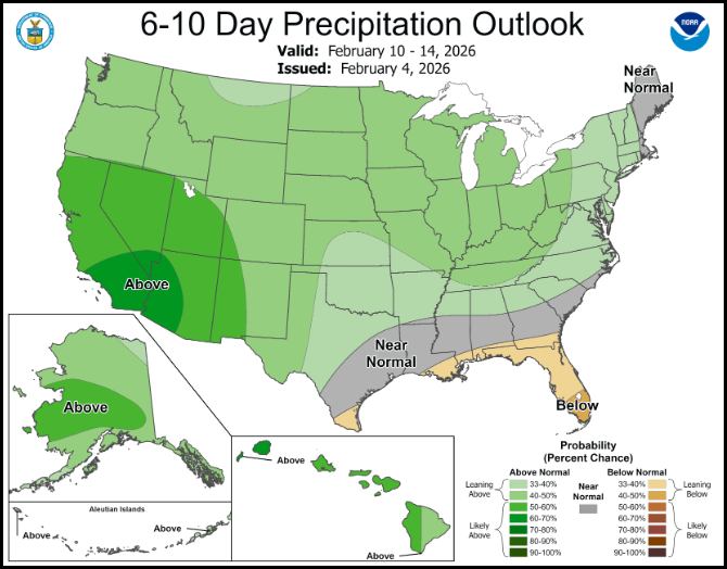
The Climate Prediction Center shows a strong chance of above-normal temperatures in its 6-10 day outlook.

Something else they indicate is slightly above normal precipitation, although it's backloaded toward the end of the period.
The way I see it, we remain dry through at least next Tuesday, perhaps even Wednesday. However, beyond that, the negative PNA opens the door to moisture, and the 13th through the 20th show this for total precipitation. The Ohio Valley and lower Mississippi Valley really get soaked.
The GFS

The Euro

For my money, it's the period from the 20th through the first week of March that looks most vulnerable for stormy weather locally. The EURO ensemble mean on the 19th shows a sweeping trough pumping energy and multiple systems across the country. That's a prime-looking pattern for a storm or two if we can pull it off. Also, remember, I discussed the trough over Alaska blocking cold air. In the depiction below, it's been displaced further southeast, and colder air is entering the pattern around the 20th. (That's the WPO reverting back to a negative stage). Some snow is certainly looking likely in that period, but at this distance it's impossible to nail down timing or track, but it's a healthy-looking signal.

The EURO ensemble mean of the weeklies shows this for snowfall from February 20th to March 20th. That's a trend to keep an eye on going forward.

Also, look at the vast extent of below-normal temperatures the weeklies depict from March 15th to the 22nd. That does not bode well for an early start to spring!

Well, they say slow and steady wins the race. That's the strategy we employ the next few days as we strive to push highs into the 40s and 50s next week. Warmer days will soon be here again! Roll weather...TS ON A SERIOUS NOTE, IF I DON'T MEET MY FINANCIAL GOALS, THIS WILL BE THE LAST YEAR OF THE SITE. IF YOU LIKE THE CONTENT, THE FUTURE IS UP TO YOU. T.S. 56% to my goal.


Comments