


STANDING TALL...
- Aug 6, 2025
- 4 min read
I had to make a trip recently that took me out of the city and into the rolling hills of EC Iowa. It was a sensational day, but winding down as the sun inched toward the horizon. In every direction, mile after mile, were fields of corn, lush and green at the stock, but tasseling and golden at the top. Maybe it was the way the light played off the Grant Wood framework, but straight up it was as beautiful as I've ever seen Iowa. After many decades of traveling this particular highway, it was like being on the yellow brick road. On either side of me, corn as high as 13 foot high guided me into the setting sun. Iowa doesn't get a lot of love for its scenery, and I certainly take it for granted, but on this day, everything slowed down, and I had a serious moment of appreciation. I suppose getting old has a way of doing that to a gray haired Iowa boy.
One of the reasons I recount this memory is that this year's corn seemed so unusually tall and healthy. I was curious to find out how the crop was evolving with a large chunk of the growing season behind us. What I found out through the USDA and the Iowa Mesonet is that roughly 85 percent of Iowa's corn crop is in good to excellent condition and standing tall. Only 3–4 years since 1986 has it been better going into August. The green trend line is 2025, the blue and red are the previous two years, and the gray are all the years since 1986.

Two reasons are responsible for the bountiful crop potential this year. One is rainfall, It's been plentiful and timely after the growing season got off to a slow start. These are Iowa rainfall totals since June 1st.

Another positive that corn thrives on, is warm muggy conditions, especially at night. As we all know, we've seen plenty of that type of weather since June.
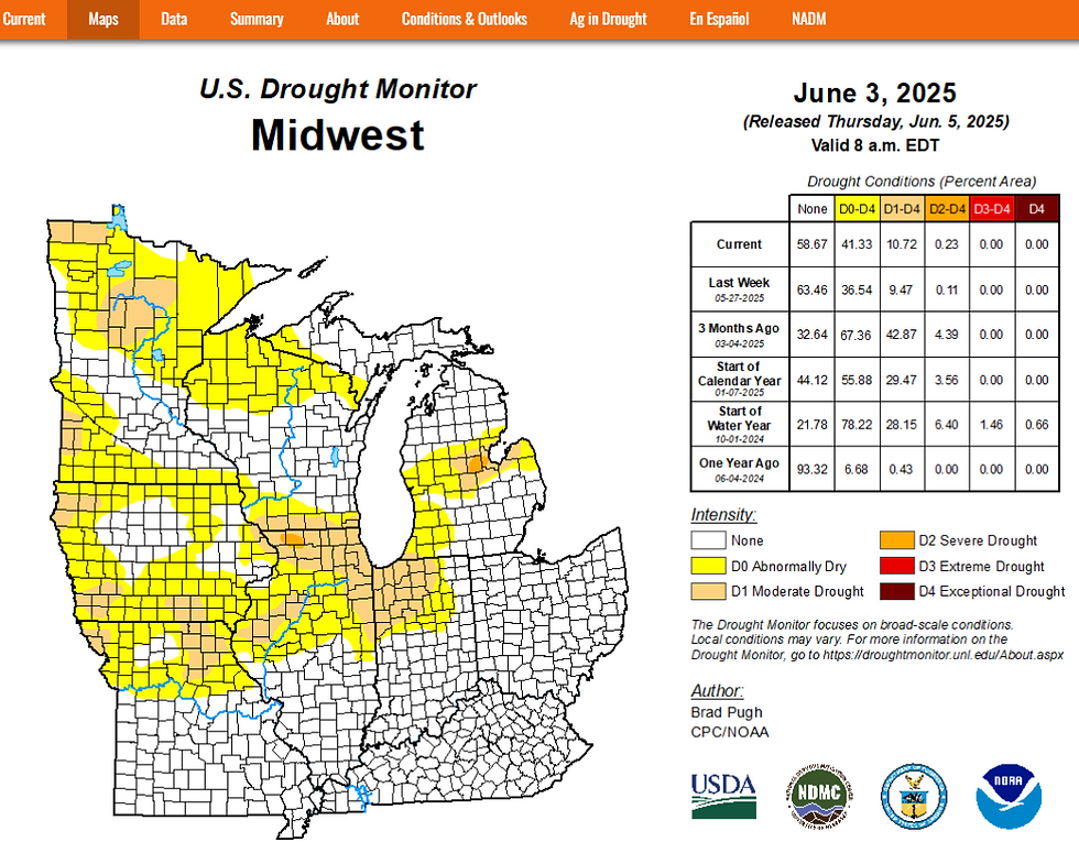
Not only are crops looking good, 91% of the Midwest is now shown to be out of drought conditions, with 8% abnormally dry.

Back on June 3rd, that was not the case. 43% of the Midwest was abnormally dry, with about 10% in moderate drought.
PLAN A VISIT TO MY 5 STAR GALENA AIRBNB

My 5-STAR AIRBNB just outside of Galena still has some openings this summer. All of our ratings are 5 star! We take pride in the amenities and the cleanliness. If you book now, we'll take off $200, and we can eliminate AIRBNB fees and additional costs that will save you big bucks. Other discounts apply. Call or text Carolyn at 563-676-3320 for our best deal of summer. See more at https://www.littlewhitechurchgalena.com/
A WETTER LOOK BY THE WEEKEND...
Wednesday will be the 7 consecutive day with no measurable rain in the Quad Cities. That will be the first that has happened there since June 9th-15th (almost 2 months). From the looks of things, much of the next 2 days should remain largely dry and with a gradual uptick in temperatures. High should generally range from the low to mid 80s. It's possible a few showers or storms could clip my far western counties Thursday, but they should be in a decaying state and not much rain is anticipated, if they can even reach that area.
Starting Friday and potentially lasting into early next week, the region gets back into a "ring of fire" pattern where we are located near the northern periphery of a heat dome. Ridge riding disturbances can exist on the north edge of the heat that are likely to trigger thunderstorms. There is also the potential that larger storm clusters known and mesoscale convective systems (MCS) could develop. Come Saturday, we'll be back to our old trick of seeing water vapor exceed 2 inches. Not only will that make for muggy weather when it's not storming, but potentially heavy rains when and where it does.

The first significant opportunity for heavy rain arrives Saturday night and Sunday morning, and then potentially again Sunday night and Monday morning. There are still some details to work out with timing and amounts, but a fairly strong signal exists for locally heavy rain in that period. Here's what the EURO and GFS suggest for rain totals.
The EURO

The GFS

Because of rain cooled air and debris clouds, guidance has come down some on weekend highs. Most spots are now shown in the low to mid 80s through Monday. That's significantly lower than the low to mid 90s the EURO was sporting yesterday. I mentioned in my last post, I thought the EURO was on the high end of max temperatures and the upper 80s of the GFS were a better option. Now, even the GFS is lower as models seem to be trending towards less in the way of heat. In fact, the latest GFS shows highs Saturday and Sunday only in the upper 70s to low 80s. Obviously, confidence is low on just how warm it well get this weekend, but I'm of the mindset low to mid 80s is a reasonable compromise.
Longer range, it's interesting to note that the EURO is expanding the heat dome into the Midwest mid-August, bringing what could be a higher, more prolonged threat of heat and humidity around August 16-17th and beyond. Here's the projected 500mb heights when the heat could be cranking August 19th.

At that time, much of the nation is shown to be above, (or much above) normal on temperatures. I'm not fully convinced yet that the EURO has this idea locked up. It will be a focus to watch going forward.

Happy hump day and if you see a nice healthy stalk of corn, appreciate it and the farmer who grew it! Roll weather...TS


Comments