


STEAMY AND STORMY...
- terryswails1
- Jun 26, 2025
- 4 min read

A warm front inched its way to the Minnesota border Wednesday, leaving the region with yet another day of hot, muggy conditions. Highs of 87 to 91 were common but with dew points in the mid 70s, heat index values in the south were back up around 100 degrees. And as expected, widely scattered thunderstorms with gully-washing rains dotted a few parts of the landscape.
At least some part of the Midwest has seen rain for at least the past 7 days. As is often the case with summer rains, amounts have varied considerably from light to excessive. One area that's been inundated is a corridor that runs from SW and SC Iowa northeast into Wisconsin. 3 to as much as 6 inches of rain has fallen there the past week. 2-3 inch amounts have randomly added up in parts of my area, especially on the Iowa side.

When you look at the 7-day percent of normal values, a bullseye is evident in SC, Iowa where weekly totals were greater than 600 percent! Some of my counties near HWY 20 are in the 300 to 400 percent category.

It's not surprising that area rivers, which had well below normal stream flows a month ago, are now experiencing significant rises. The colored boxes represent gauges that are at (or will be at) action, minor flood, or moderate flood levels. With a couple more rounds of heavy rain possible, the stages could go higher in spots.

As it stands now, the Cedar River in Cedar Rapids is expected to be only 1/2 foot below major flood stage July 2nd. As that wall of water moves downstream, a moderate stage is eventually possible in Conesville, Iowa

The Wapsi at DeWitt should eventually reach moderate stage by July 2nd.

The Mississippi will also see some rises, but it takes longer to have impacts as the various tributaries throughout the basin empty into it. We should a better idea of how that plays out after the rains are totaled the next 4 days. At this point, nothing problematic is anticipated.
HOT TEMPS, HOT DEALS AT MY GALENA AIRBNB

My 5-STAR AIRBNB just outside of Galena still has some openings this summer. All of our ratings are 5 star! We take pride in the amenities and the cleanliness. If you book now, we'll take off $200, and we can eliminate AIRBNB fees and additional costs that will save you big bucks. Other discounts apply. Call or text Carolyn at 563-676-3320 for our best deal of summer. See more at https://www.littlewhitechurchgalena.com/
A STORMY END TO A STEAMY DAY?...
While a couple stray storms may fester for a time early Thursday, especially in the north, significant heating is again expected ahead of our next round of storms Thursday evening. Highs of 88 north to 93 south are expected. Dew points in the low to mid 70s will not only make for another sultry day, they will lead to plenty of instability to support storms when the front arrives in the early evening. The HRRR near the front shows CAPE up to 3000 j/kg around 6:00pm.

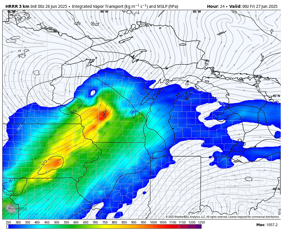
That lines up well with the simulated water vapor, showing the moisture pooling ahead of the frontal induced forcing.
The simulated radar of the HRRR shows a healthy line of storms entering my western counties by 8:00pm. Thursday.

The bright red blobs on the simulated satellite are the cold cloud tops of the thunderstorms anvils that may reach heights of up to 45,000 ft.

If we get the heating that's advertised, I would think some storms could reach strong to severe limits. High winds would be the most likely component of the more intense updrafts. You can see helicity tracks are evident, which does imply some rotating updrafts and potential supercells. Several very intense long tracked supercells are indicated further north in Wisconsin where a tornado or two is possible where winds are more backed.

With water vapor maxed out at 2 inches Thursday evening, deep tropical moisture is in play and any respectable thunderstorm is likely to be an efficient rain producer. Amounts of 1-2 inch in an hour are not out of the question. The bigger challenge will be how widespread those excessive rains will be. The latest trends have shown a tendency for the heavier amounts to be further northwest, with only smaller pockets of heavier rains locally. I can't say that's a sure bet yet, due to mesoscale details that won't be known until later Thursday morning.

The HRRR (high resolution rapid refresh) shows amounts like this through Thursday night. As I mentioned, other models are far less aggressive regarding totals, so confidence is lower on rain amounts than I would like to see 24 hours from the actual event.

Behind the system Friday, any lingering showers or storms depart the southeast early. Somewhat cooler and drier air will be in play and that will make for some improvement in our overall weather. Highs of 80-85 currently look reasonable.
Saturday and Sunday, very warm temperatures and increased humidity returns to the forecast. While a stray shower or storm is possible in such an environment, they look few and far between. Most of the region stays dry, warm and muggy with highs 86 north to about 90 south.
Sunday evening, a final round of storms is set to do their thing as another cold front makes a run at the region. The EURO has been consistently showing a healthy line of convection (squall line) with this forcing as it dives southeast. It bares watching as it could bring some gusty winds and additional downpours if timing holds. Here's the cluster of storms on the EURO around 10:00pm. Sunday evening, surging south.

As the system passes, it will switch the upper level flow to northwesterly for several days next week, with a notable decrease in humidity and seasonally warm temperatures. By the 4th, there are signs the heat and humidity and a few storms might make a renewed run at the area for the holiday.
First things first, and that's the active weather that's possible towards tomorrow evening, following what should be another toasty June day. Until next time, roll weather...TS


Comments