


SUMMER COMES IN HOT...
- Jun 21, 2022
- 3 min read
As of 4:14am Tuesday, it's officially summer. Believe it or not, the days start getting shorter now and we all know how that story ends in 6 months. At any rate, for those of you waiting for summer we are in it now and boy is it going to feel like it. The HRRR is pointing to heat index values Tuesday afternoon in the 100 to 106 degree range. That warrants a heat advisory for the entire area.

Here's what the hi-res HRRR indicates for heat index values Tuesday afternoon.

The hi-res HRRR actually shows highs hitting 100 from Keokuk to the Quad Cities. The only way that happens is if dew points mix out and fall into the low to mid 60s during peak heating. I suspect that's a push and I think max temperatures will end up more in the range of 93 north to about 97 south. Maybe a stray spot or two in the SW hits 98 or 99.

The next order of business revolves around rain chances late Tuesday afternoon or night when a cool front drifts into the region. The heat and humidity that builds during the day creates significant instability with CAPE potentially reaching 4,000 j/kg plus. That's a lot of energy for thunderstorms.

There are some big negatives that have to be overcome before storms are realized. One is a mid-level cap (warm air aloft). Others are weak forcing and minimal shear. If storms can pop in scattered areas, the updrafts may have a hard time sustaining themselves if the cap remains strong. It's going to be a real battle to see if the positives can overcome the negatives. Right now I'm leaning towards a drier solution with the best chances of anything meaningful from roughly the Quad Cities southeast. I could see a couple brief strong storms go up with some gusty winds and short downpours. These should be few and far between unless we can generate a decent cold pool to sustain storms and that seems unlikely. Here's what models are suggesting for rain totals through Tuesday night.
The EURO

The GFS

The HRRR

The 3K NAM

With the front sinking into Missouri late Tuesday night and eventually stalling, somewhat cooler and less humid weather will follow Wednesday and Thursday. Highs both days should return to the low to mid 80s in most spots. The far south could see some upper 80s. Both days appear dry with moderate humidity. Pretty good days!
Friday through Saturday, the stationary front becomes active and makes an attempt to push further north towards Iowa. We should get into a position that places us near the northern periphery of the heat dome located just to our south. If indeed that's the case, the "ring of fire" is in play and we could find ourselves with a couple shots at nocturnal storms, potentially even an MCS. Again these are hard to pinpoint but they can produce some good rain and even some strong storms. We will need to watch this period for some active weather.
It does appear a strong cold front will spear the Midwest Saturday night after what should be another very warm day that could be followed by evening storms. Breezy and much cooler conditions are set to return Sunday and much of the following week. Look at the 7 day departures the GFS shows for the period June 26th through July 3rd. That should bring highs in the 70s with minimal humidity.

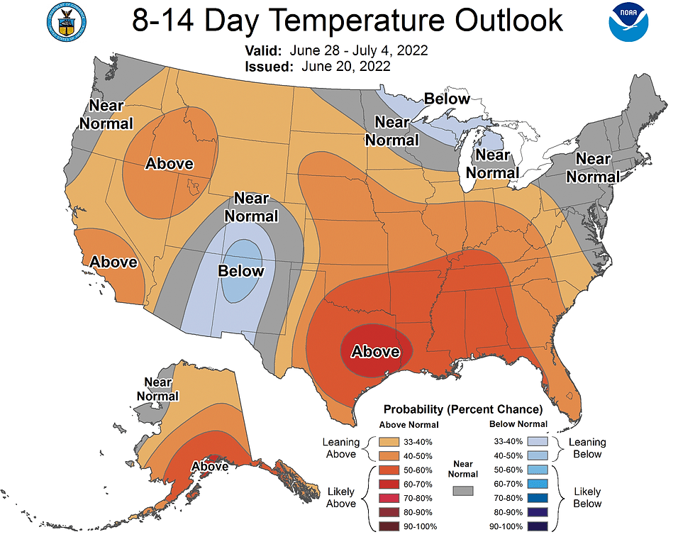
That's not what the Climate Prediction Center is showing with its above normal temperature outlook June 28th-July 4th. I would not be surprised if their outlook ends up being cooler in days to come.
One thing's for sure, Tuesday will be far from cool as summer takes its rightful 3 month reign. All hail the solstice! Stay cool and as always, roll weather...TS


Comments