


SUMMER IN THE CITY...
- Jul 9, 2025
- 4 min read
We are well into July, and that usually means weather patterns tend to slow down a bit as the seasonal jet weakens due to the absence of cold air. Moisture is typically available, leading to a more humid pattern. The advent of tasseling corn also adds to the muggy conditions through the process of evapotranspiration (the corn sweats just like us at this stage in its development). All these factors in a sluggish atmosphere can lead to diurnal thunderstorms when afternoon heating reaches a specific temperature. These cells, known as pulse storms, pop up quickly and dump their rains before rapidly decaying. However, with weak steering currents, they barely move along and have the ability to produce localized rains of an inch or two in short order. With these single cell storms, one side of town gets a gully washer while the other side misses out altogether.
Single cell thunderstorms have a 3 stage life cycle beginning with the developing stage.

From there it evolves into the mature stage.

Finally, cells becomes downdraft dominated cutting off inflow and the updraft causing it to dissipate.

The last 3 days, these individually driven pulse storms have produced isolated but significant pockets of heavy rain. One formed near Long Grove (north of the Quad Cities) Tuesday afternoon. At nearby Glynn's Creek golf course 3.37 inches of rain poured down in a minimal period of time. 1 mile SE of Fulton, 3.07 inches was measured. Further west in Cedar Rapids, 4 miles NE of the municipal airport, 2.32 inches came down in about 1 hour's time. Here's the Doppler rainfall estimates of where the heavier rains were found over the past 24 hours. Green correlates to at least 1/2 inch of rain, and yellow indicates amounts of 2 inches or more. The area between HWY 30 and I-80 had the greatest totals. About 40 percent of the area saw nothing at all. From a forecasting standpoint, it's extremely difficult to pinpoint with any degree of accuracy where the storms will occur due to the lack of forcing (something like a cold front to focus on). All you can do is say the chance exists, then sit back and watch them spring to life

Wednesday coverage should be lower, (15-25%) coverage at best, meaning much of the area avoids any meaningful rain thanks to lower dew points. Thursday, moisture starts to increase again and odds are a bit higher (30-40%). That still means 60% of us should miss out on wet weather. The area west of the Mississippi is where the higher chances exist. Temperatures both days will warm into the range of 84 north to 88 south.
PRIME TIME TO VISIT TO MY 5 STAR GALENA AIRBNB

My 5-STAR AIRBNB just outside of Galena still has some openings this summer. All of our ratings are 5 star! We take pride in the amenities and the cleanliness. If you book now, we'll take off $200, and we can eliminate AIRBNB fees and additional costs that will save you big bucks. Other discounts apply. Call or text Carolyn at 563-676-3320 for our best deal of summer. See more at https://www.littlewhitechurchgalena.com/
AN ACTIVE START TO THE WEEKEND
Thursday night, and especially Friday, the potential exists for a more active period of thunderstorms, depending on how mesoscale details come together. One thing seems certain and that's the fact moisture is highly focused on the area with water vapor late Friday on the order of 1.80 to 2.20 inches areawide. That in itself lends itself to a heavy rain threat.

Additionally, highs of 85 to 90 will build some impressive instability, with CAPE in spots exceeding 3,300 j/kg. on the EURO.

The lightning density flash rate ending at 7:00 pm. shows plenty of lightning with potentially strong storms lifting NE into the area ahead of a cold front. Shear is also looking better than what we've seen with recent events, which could lead to stronger storms. One of the big unknowns at this point is the amount of convection that flourishes during the day. That, and any debris clouds, could temper the instability that otherwise would be high without it.

It now appears that the system will be slower to depart Saturday, which could keep some showers and clouds going into the morning. The GFS is more progressive than the EURO and clears things out early in the day. Either way, cooler air and lowering dew points will improve conditions, particularly Sunday.
After Friday's steamy and potentially stormy day, the GFS keeps the region void of any serious heat through the 20th, which by the way is statistically the hottest time of the year. While I doubt it will happen, the GFS even shows a high of 68 the 17th which is at least 15 degrees below normal. That would certainly come with minimal humidity, if indeed the cool punch materializes. Beyond that, hotter weather shows up later around the 23rd and 24th.

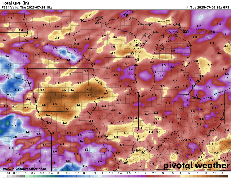
As for precipitation, the GFS really goes ballistic the next 2 weeks, showing totals that are highly above normal from my area west. Note some 10" amounts from Cedar Rapids to Des Moines. Most likely there is a lot of convective feedback that's inflating totals, but this is the time of year things like that can happen if you get a stagnant pattern that lays down a stationary boundary for 7–10 days (a ring of fire type set-up). I'm not too concerned about it at this point.
That will do it for now. Have a great day and roll weather...TS


Comments