


THE CRYSTAL BALL IS CLEARER
- Feb 14
- 4 min read
A SPECIAL MESSAGE, LET'S GET IT DONE

I would like to thank the 289 amazing people who have stepped up to the plate and made a donation to fund the site through this December. In the past year, TSwails had over 600,000 sessions, which breaks down to less than 1 donation per session. If you do not find value in the site or don't have the funds, I understand and still welcome you with open arms. For those of you here daily, who gain knowledge, or make financial decisions based on the information, I ask that you make a reasonable contribution. Every little bit helps. After much deliberation, I've decided that due to the daily commitment of time, money, and hard work, this will be the last year for the site if I can't reach my financial goal. I'm 80 percent there. The future depends on you. Thank you for your consideration and support the past 13 years. T. Swails
NO WAY TSWAILS ROOTS FOR WARMTH IN THE WINTER
One of my TOP FANS according to Facebook, posted this question: Terry, when did you start rooting for warmth during the winter? I always liked how you were hoping for cold and snow and it seems that has changed recently!
Holy cow, I never thought anybody would say anything like that. As I responded to him, I've never seen a snowflake I didn't like! And, just for the record (in case I'm losing my mind and communication skills), I'm all in on winter! There is nothing more that I enjoy than the challenge of nailing a snowstorm. I'm up at all hours looking at models to find an edge and be out in front of the trends. It's a passion, or maybe a sickness. It's very personal to me and I truly love trying to piece it all together. I sincerely believe forecasting is what I was put on this earth to do. It gives me a purpose and we all need that.
I will also say another thing that I absolutely crush is setting on the deck on a hot humid night watching a lightning show come over the river. I'm talking about the kind where its pop, pop, pop, one after the other, non-stop. It's one of the greatest shows on earth. The dog, cat, or both, will sit with me until they call it quits when their instincts tell them its wise to make a move. Frank the cat is a stud, he always hangs the longest. It's good to have a friend, as well as purpose.
NEAR RECORD HIGHS MONDAY
Now that we've settled that burning question, lets get into what's headed our way. So far things are on track for a mild, quiet 3 days ahead. Temperatures Saturday may be 2-3 degrees cooler, especially in the south. That's due to system you can see on the satellite that tracks through the lower Mississippi Valley. Its rain stays to the south, but some high clouds will spin north into the area. They will be more pronounced in the south and that's why it should be a bit cooler there.

Once that slides by, it opens the door for a western trough to amplify Sunday into Monday. As a result temperatures should rise again into the range of 55-60 Sunday and 58-63 Monday. The record high in Moline Monday is 60 degrees and that is in real jeopardy. Here's the upper air flow that does it.

What's particularly interesting is that even with that impressive trough out west, it's not tapping moisture. Monday morning available water vapor all the way to the gulf is pathetically low.

Come Tuesday water vapor transport is finally improving but about the time it gets here the forcing that's in place is shifting north. There may be a period of light rain or showers Tuesday night, mainly north of I-80. They won't amount to much even if they do develop.

Another thing to watch Tuesday is a back door cool front that is shown slipping south out of Minnesota and Wisconsin, turning winds E/SE. The EURO is adamant about lowering temperatures in all but the far south. Near HWY 20 highs are down a good 10 degrees in the low 50s. Mid 50s are down to I-80.

The GFS still has 60s up to the Minnesota border completely not catching the depth of the shallow but dense cold air at the surface. I think its very likely way too far north on the warmth Tuesday and I highly doubt its solution. I've seen this a lot over the years and I'm basing this on pattern recognition (or experience).

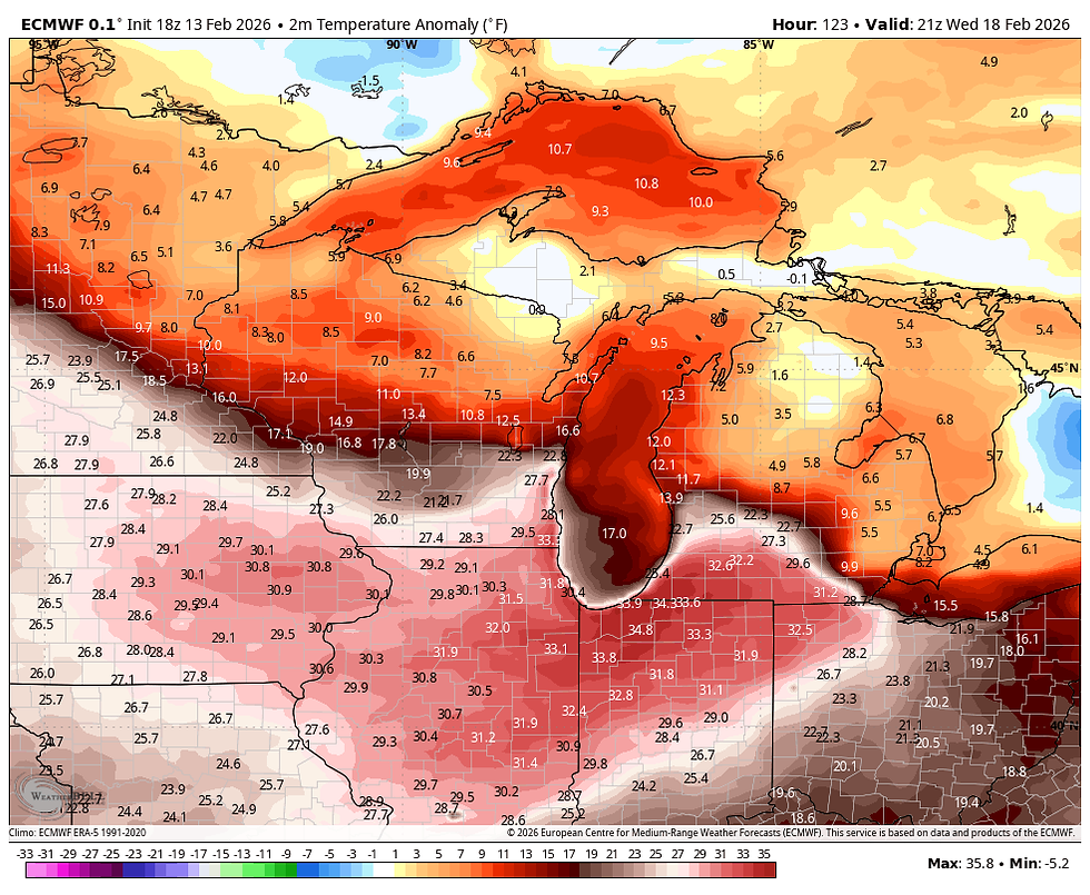
Anyway, we get our shot at a few showers Tuesday night before another system rapidly develops to the northwest Wednesday. As it advances across NE Iowa Wednesday it pulls the back door front back to the north allowing another surge of warmth Wednesday. It may in fact be the warmest day of this whole sequence of mild days. The EURO is now promoting highs of 61 north to 68 south!

For perspective, those readings are 30 degrees above normal.
Finally, another fast moving, relatively dry disturbance whips by Thursday. Energy parcels are passing so quickly moisture is struggling to get into them. This allows one more relatively mild day Thursday.
Friday and next weekend the party is over for now as the pattern turns colder and temperatures return to more seasonal levels of 35 to 40 for a time. Once again, I'm afraid to say I see little beneficial precipitation locally through next weekend. Over the next 15 days through the 24th, the GFS and EURO show this for totals.
The GFS


I am amazed that it appears we will get out of this energetic western based trough with nothing to show for it but mild weather. I guess it is what it is (you get what you get). Until next time, roll weather...TS
ON A SERIOUS NOTE, IF I CAN'T MEET MY FINANCIAL GOALS, THIS WILL BE THE LAST YEAR OF THE SITE. IF YOU LIKE THE CONTENT, THE FUTURE IS UP TO YOU. T.S. 80% to my goal.


Comments