THE DEEP FREEZE...
- terryswails1
- Apr 20, 2021
- 2 min read
For those of you down south, (especially near and south of HWY 34), your Tuesday got off to a wintry start. As expected snow made an appearance with totals of 1-2 inches, heaviest down near the Missouri border and into WC Illinois. The Iowa Mesonet shows this for accumulations.

Another perspective from the NWS in the Quad Cities through 9:00am Monday.

Hear you can see the widespread footprint of the storm as it laid down snow from the Rockies all the way to Maine. That's pushing the envelope for late August.

As exceptional as this is, it pales in comparison to what went on from April 19 to the 21st of 1918 when Lenox, Iowa measured 25.2" of snow. 24" fell on the 20th and to this day that is the all-time calendar day record for 24 hour snowfall in the state of Iowa!

Off the topic of snow, the big issue now is the chilly temperatures that will rule the next couple of days, especially during the overnight hours. Lows Wednesday and Thursday morning are likely to end up in the mid to upper 20s. A hard and potentially damaging freeze is expected over all of my area. A freeze warning is in effect through the early morning hours of Wednesday. Here's what the hi-resolution HRRR is showing for temperatures near daybreak. Some areas could threaten record lows.
Wednesday morning

Thursday morning

These are the freeze warnings in effect until 9:00am Wednesday

You can see that many parts of the Midwest will be impacted by frost and freezing temperatures.

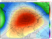
At least readings will moderate some during the daylight hours as we close out the week and push into the weekend. Things really warm up next week with the EURO showing highs near 80 next Tuesday. Unfortunately, the reprieve from the cool weather is brief as the EURO has highs back down into the mid 40s April 30th.

The warming and cooling both make sense as the MJO gains amplitude and zips into phase 8 by next Monday. See how the phase 8 temperature analogs are warm in April.

However, by April 30th the MJO is entering phase 1 and the temperature analogs for that period are very cool over the central U.S. Phases 2 and 3 are also below normal in May and that's probably where the MJO is headed after departing 1.

Well, at least there's some good news for a time as the worst of this round of cold kicks out late in the week. With that, I'll call it a post. Only two more days until I leave for Iowa. Hot dang, homeward bound! Roll weather...TS


Comments