


THE DOUBLE SHOT, SNOW AND BITTER COLD...
- Feb 10, 2021
- 3 min read
LIMITED COPIES LEFT:
A SECOND PRINTING OF MY NEW BOOK IS ON THE WAY...

NEW COPIES OF DERECHO 911, IOWA'S INLAND HURRICANE ARE AVAILABLE. Around Christmas we sold the last of the 1500 copies of our book on this historic thunderstorm, the most damaging in U.S. history. Due to continued demand we ordered a limited number of 250 for those of you interested in having the most authoritative account of this extreme event. Books are selling fast so don't miss this opportunity to own the weather story of a generation. You can get yours at derechobook.com
I ordered one of your Derecho books about the storm in Cedar Rapids, IA back in December. I love it! I had also bought one that the Cedar Rapids Gazette sold. Your book by far is so much better, you have a lot more pictures and it just tells more of the story. Thank you for putting a wonderful keepsake together! Do you have any left? If so can you tell me how to get at least one more.
Thank you so much! Penny Brecke
CRASH AND BURN
Skies cleared out Monday night and that's all it took for temperatures to crash and burn. By Tuesday morning Waterloo hit 21 below, Marshalltown -20 and Cedar Rapids 19 below! Readings actually dropped a couple degrees after this graphic was posted by the NWS at 6:00am Tuesday.

Very deep snow cover by Midwest standards was a contributing factor to the harsh cold in spots near and north of I-80. Much of that area has a 12 to 18" base.

This is turning into a good year for snow across the mountains of the west and the northern half of the nation. Everywhere you see yellow at least a foot of snow has fallen. Lots more than that in the orange and red tinges.
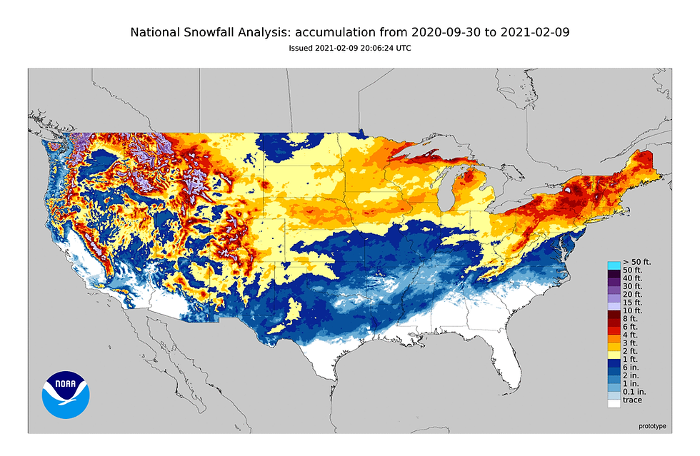
In the Midwest some of the heaviest snow has fallen in a swath that extends from Omaha to Des Moines and on to Dubuque. Along that line 45-50" totals are common.

Amounts like that are 25 to 30" above what's typical. Here are the departures.

Most of my are near and north of I-80 is running 200-300 percent above average.

And, there's more to come, although it will be manageable! Critically, there is nothing through the weekend that would qualify as a storm, just minor ripples of forcing that will act on the Arctic air to generate additional bands of light snow or flurries through Saturday. Some is already a threat Wednesday, mainly south of I-80 but amounts are expected to be 1" or less. A more widespread potential exists in all areas later Thursday through Saturday. During that period 1 to 4 inches (perhaps 5) of light fluffy powder is possible. This is what models are showing. Remember, these are not official forecasts, just model guidance that help shape our outlooks.
The EURO

The GFS

The Canadian GEM

Regarding temperatures, with considerable cloudiness anticipated the next few days, nighttime lows will be tempered sparing us from lows that would otherwise be 10-20 below. However, readings will still be cold with lows 0-5 and highs 5-10 through Friday. There are indications of another round of bitterly cold temperatures and wind chills at some point this weekend. The GFS is extreme and brings the surge in by Saturday. The EURO is not nice but is nowhere near as vicious holding the bitter cold just to the northwest. Let's hope the EURO is correct because this is what the GFS is bringing. I would say it's far too cold and what I would term as the worst case scenario.
These are the GFS lows Sunday which in some spots are near all-time records around 30 below.

The GFS also shows widespread wind chills in my area of 47 to 55 below Sunday morning! Very dangerous and quite unusual.

I'm betting on the more conservative EURO and while Sunday and Monday lows of 5-15 below are possible with wind chills of 20-30 below, the extreme cold of the GFS seems unlikely...I sure hope so!
I wish I could sugar coat it but the next 6 or 7 days are just not going to be kind. It's one of those deals where you hope for the best and prepare for what looks to be the worst in terms of cold and light to perhaps moderate snow. Keep your head down and forge on, only 18 days until March (meteorological spring). Roll weather...TS


Comments