THE GOOD NEWS TRAIN IS ROLLING...
- May 6, 2022
- 3 min read
Score one for the GFS. Yesterday it was downplaying rainfall from the disturbance that's been impacting our weather the past 24 hours with clouds and spotty showers. It showed little rain north and only light amounts across the south. The EURO on the other hand was far heavier and further north (as was the GEM). See the comparison of the two models below.

Much of the EURO's rain was to come Thursday night and early Friday when forcing was shown to be maximized from a second wave of energy. Today the deformation band from that wave is shown consistently further southeast (as the GFS has been indicating). Here's what the EURO and GFS are now indicating for rain amounts Thursday night through Friday. As you can see, the best chances for measurable rain Friday will be near and east of the Mississippi. With the clouds, temperatures will remain cool with low 60s west and only 50s east where showers are more prevalent.
The EURO

Less rain combined with much warmer temperatures next week is especially good news for farmers who have battled cool wet weather all spring. Fieldwork is behind schedule and warmer conditions will allow planting to progress while stimulating seed germination where there's a few kernels in the ground. This was really needed.
MOTHER'S DAY WEEKEND
Overall, pretty good weather is expected. With Friday's storm out of the picture, partly cloudy skies Saturday will allow light winds and highs of 65 to 70. Sunday (Mother's Day), warm air advection will drive some showers and storms to the west that will advance towards the region later in the day. There is a chance these hold together but the rain will be in a decaying state and appears to be spotty and light. Best chances would be west of the river and in the afternoon. Depending on the amount of cloud cover, highs should end up again in that 65-70 degree range.
Then it's time to turn up the heat. Southwest flow develops Monday and holds tight through next week.

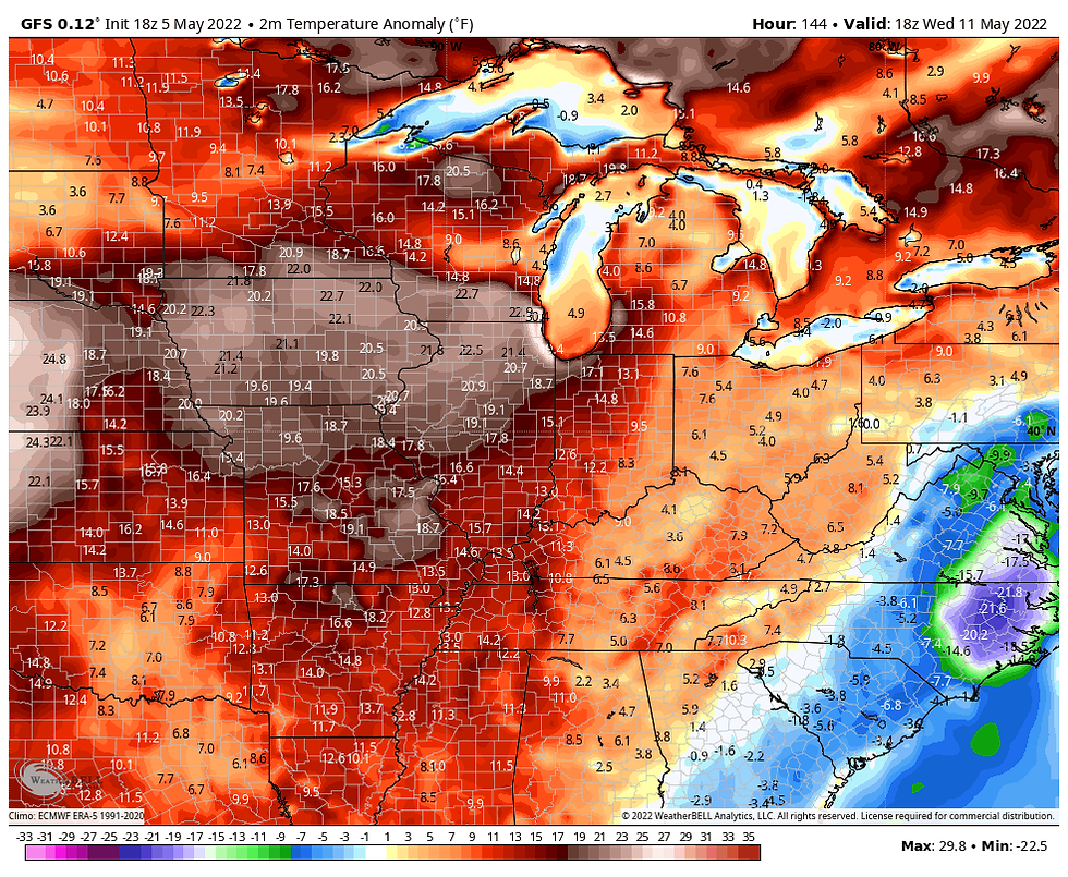
Very warm July-like temperatures will explode on the scene next week and highs Monday through Wednesday will likely be in the upper 80s to potentially 90. Here's the 7 day temperature anomalies Monday May 9th to Monday May 16th.

The warmest days will be Tuesday and Wednesday when readings 20-25 degrees above normal are shown on the GFS.

These are the projected highs Wednesday on the GFS.

Notice too the high water vapor levels. Dew points well into the 70s will provide us with our first real taste of the muggies. With the support of the GFS, heat index values could reach into the low to mid 90s. Good corn growing weather for those select areas that have the crop in the ground.

Here's the long range meteograms from the EURO and GFS. Both show a nice stretch of well above normal temps.
The EURO

The GFS

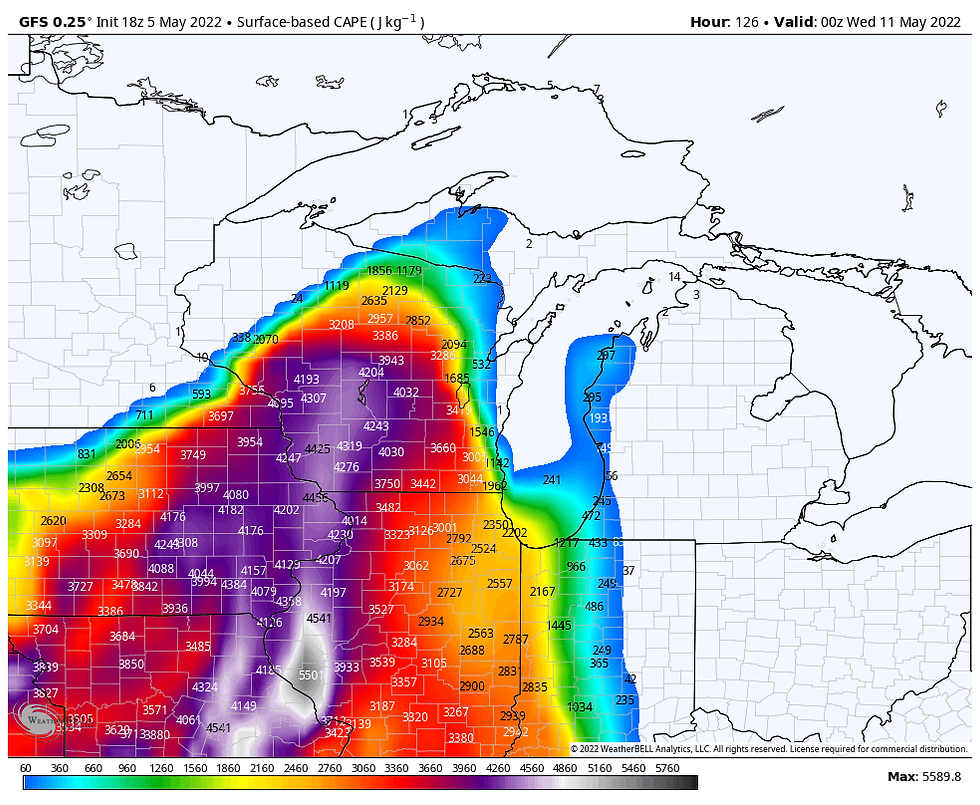
Despite all the warmth, increased humidity and instability, the primary storm track appears far enough north to keep much of the thunderstorm threat next week confined to the upper Midwest. I'm still watching Tuesday evening or night for a storm threat as a disturbance ripples southeast on the edge of the cap. CAPE is very substantial and would produce some robust updrafts if storms can fire.

In conclusion, Friday will be another cruddy day and then we turn the corner and start the long journey to the top of the thermometer. Buckle up! Happy Friday and roll weather...TS


Comments