


THE RAIN MAN COMETH...
- Jun 3, 2025
- 3 min read
We all had a healthy (and very welcome) rain back around May 20th when much of the area picked up rain that totaled 2-4 inches. The majority of rain fell over a 2-day period

Between May 19th and the 22nd, some areas near the Quad Cities saw departures greater than 3 inches.

Since that time, the rains have been spotty and light, with Cedar Rapids picking up a total of just .01 inches the past 11 days. Things have certainly dried out again and another soaker would be good for crops, gardens, grass and flowers. From the looks of things, odds are good that most areas see 1/2 to 1.50 inches of rain from a system which eases across the Midwest Tuesday into Tuesday night.
One thing that's a bit ambiguous is where the heavier totals end up falling. Current expectations are that the remnants of showers and storm that formed over the Plains late Monday will make a run at my counties in eastern Iowa Tuesday morning. As they out-run their upper air support, they are expected to weaken. Amounts in this initial round of precipitation should largely be on the light side unless any waning convection can hold together longer.
By early afternoon, there should be a relatively rain free period where some limited breaks in cloud cover occurs. The amount of heating that takes place will determine the amount of instability for a new round of showers and storms to develop later in the afternoon and evening ahead of the advancing cold front. There is a pronounced area of water vapor integrated into the atmosphere across my area.

Actual water vapor is shown at 1.75 to nearly 2.00 inches around 8:00 p.m. Despite all the moisture, clouds and limited heating have kept instability rather modest with CAPE generally under 1,000 j/kg.

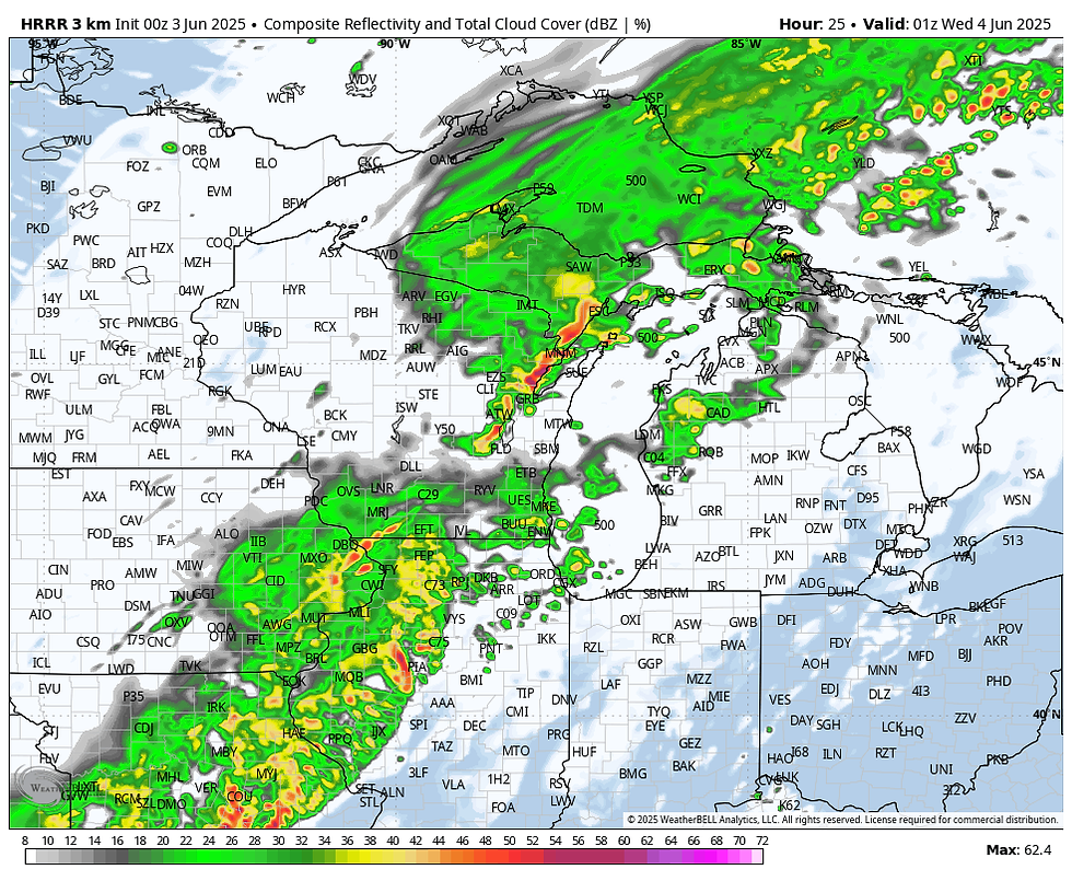
Even so, the simulated radar of the HRRR shows showers and embedded thunderstorms covering much of eastern Iowa and western Illinois at 8:00 p.m.
The EURO's 3-hour lightning flash rate between 7 and 10:00 p.m. Tuesday evening, certainly indicates thunderstorm development advancing across most of the region.

There are also some cold cloud tops apparent on the simulated satellite, indicating some of the storms could border on severe.

How strong will again be heavily dependent on how much heating storm updrafts can gain access to. I don't see much more than a few strong wind gusts with the existing parameters. The Storm Prediction Center does have my entire area highlighted in a level 2 slight risk outlook, mainly Tuesday afternoon and evening.

The biggest concern is pockets of heavy rain. With water vapor at such high levels it would not take much to wring out an inch of rain, maybe 2, if multiple storms hit a given area. As I mentioned earlier, models are somewhat conflicted on where the heaviest rains line up, and the mesoscale details that determine that won't be known until at least mid-morning Tuesday. For now, here's what the Monday night trends suggest.
The EURO

The 3k NAM

The HRRR

The GFS, shows a convective bullseye in central Illinois of 7 inches, which I have no doubt is overdone.

NOW IS THE TIME, GREAT DEALS AT MY GALENA AIRBNB

My 5-STAR AIRBNB just outside of Galena has a number of openings yet this summer. All of our ratings are 5 star! We take pride in the amenities and the cleanliness. If you book now, we'll take off $200, and we can eliminate AIRBNB fees and additional costs that will save you big bucks. Other discounts apply. Call or text Carolyn at 563-676-3320 for our best deal of summer. See more at https://www.littlewhitechurchgalena.com/
COOLING DOWN MIDWEEK...
Any lingering rain is likely to be out of my eastern counties in Illinois early Wednesday. After that, things appear pretty quiet through at least Thursday, although some passing clouds are possible. Friday, the GFS is all jacked up about another wet system. It may happen, but the baroclinic boundary appears too far south for much more than some clouds, and maybe a few spotty showers this far north, mainly south of I-80.
With east northeast winds prevailing through most of Saturday, that will keep temperatures in check Wednesday through Sunday. The EURO meteogram in the Quad Cities has highs that fall mainly in the mid to upper 70s, maybe 80 again towards Sunday.

As you can see on Monday night's satellite, there are storms to the left of us and wildfire smoke to the right, and I'm in the middle with you, waiting for the rain man.

Have a terrific day despite some unsettled moments. Roll weather.....TS


Comments