


THE RETURN OF STORMS?
- Jul 15, 2025
- 3 min read
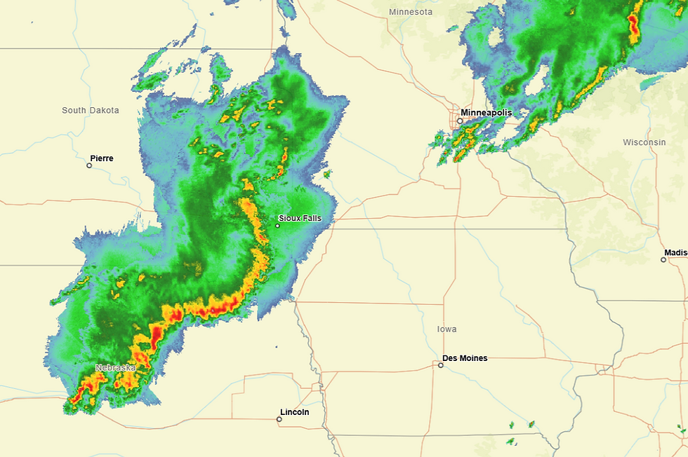
Warm muggy conditions prevailed around the region Tuesday, signaling the return of what could be thunderstorm weather Wednesday afternoon and evening. Storms are raking parts of the upper Midwest and Plains and can clearly be seen on the Infra Red satellite imagery. Question is, what will their remains produce in the way of thunderstorms here Wednesday?

What's left of this impressive line of storms approaching NW Iowa is expected to largely dissipate before reaching central Iowa Wednesday morning. As it weakens, the release of latent heat from the complex will cause a spin in the mid-levels of the atmosphere known as an MVC. This energy or vorticity will be the lift for additional storms further east Wednesday afternoon.
Before they spring to life, enough heating is anticipated to get highs into the range of 85 to 90.

Add to that water vapor approaching 2.50 inches, and you have the ingredients for significant instability and most certainly excessive rains of 1–2 inches in the stronger updrafts. Dew points could reach the upper 70s in spots.
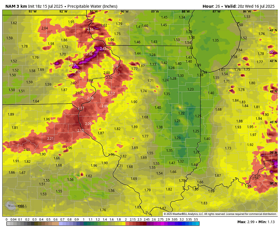
WPC is showing a slight risk outlook for excessive rains over my entire region.

A NEW WRINKLE...
New data is coming in and CAMS (convective allowing models) have shown a northward shift on where the MCV tracks and where storms should fire by 3:00pm. The 18z run of the 3k NAM Tuesday afternoon had a potent looking line entering my central counties at that time.

However, the latest 0Z run Tuesday night now keeps most of the action just north of my area

The latest HRRR has a similar look, with a potential CAP further south in much of my area.

The latest EURO though retains the more southerly track of the MCV and its precipitation. Needless to say, there is quite a bit of doubt as to how Wednesday unfolds, and the forecast has become low confidence. The higher resolution CAM models were designed to catch trends like this, and their less stormy outcome may be on the right track. At least for now, scattered strong storms remain possible, but are not as probable as it looked earlier Tuesday. We should have a better grasp of how the mesoscale details align as the morning unfolds Wednesday. It would be nice to get out of this without much rain or severe weather.
You certainly can see in the rain forecasts how the HRRR and 3K keep the heavier rains north and south. Totals in much of my area are generally light or non-existent.
The 3K NAM

The HRRR

The EURO has a more widespread rain threat for much of the region.

IT'S TIME TO VISIT TO MY 5 STAR GALENA AIRBNB

My 5-STAR AIRBNB just outside of Galena still has some openings this summer. All of our ratings are 5 star! We take pride in the amenities and the cleanliness. If you book now, we'll take off $200, and we can eliminate AIRBNB fees and additional costs that will save you big bucks. Other discounts apply. Call or text Carolyn at 563-676-3320 for our best deal of summer. See more at https://www.littlewhitechurchgalena.com/
THE GOOD STUFF...
Once this mess departs, some very fine weather sets in for the end of the week. Highs dip to the 70s Thursday as drier air pours into the Midwest. That sets the table for a fabulous Friday with sunny skies and highs of 75 to 80.

Even better, dew points crash into the mid 50s, very impressive for mid-July!

Now that's the way to end the week. Roll weather...TS


Comments