


THE WALL OF SHAME...
- Feb 13
- 5 min read
A SPECIAL MESSAGE, LET'S GET IT DONE

I would like to thank the 285 amazing people who have stepped up to the plate and made a donation to fund the site through this December. In the past year, TSwails had over 600,000 sessions, which breaks down to less than 1 donation per session. If you do not find value in the site or don't have the funds, I understand and still welcome you with open arms. For those of you here daily, who gain knowledge, or make financial decisions based on the information, I ask that you make a reasonable contribution. Every little bit helps. After much deliberation, I've decided that due to the daily commitment of time, money, and hard work, this will be the last year for the site if I can't reach my financial goal. I'm 78 percent there. The future depends on you. Thank you for your consideration and support the past 13 years. T. Swails
THE WALL OF SHAME...
It never fails, every spring we are tantalized by surges of early season warmth. The longer days and more direct rays of the sun start to do thier dirty work, especially in the southern U.S. When we get the jet stream in the right configuration some of this warm air can take a run at the Midwest. That's the situation we find ourselves in the next few days.
One of the issues models can struggle with are back door cold fronts originating off the cold water of the Great Lakes. Any snowcover near the lakes can also enhance the effect. When winds swing to the E/NE, they can tap the cold dense air and push it west of the lake water. Historically, Lake Michigan is known for thwarting big warm ups locally, particularly north of I-80.
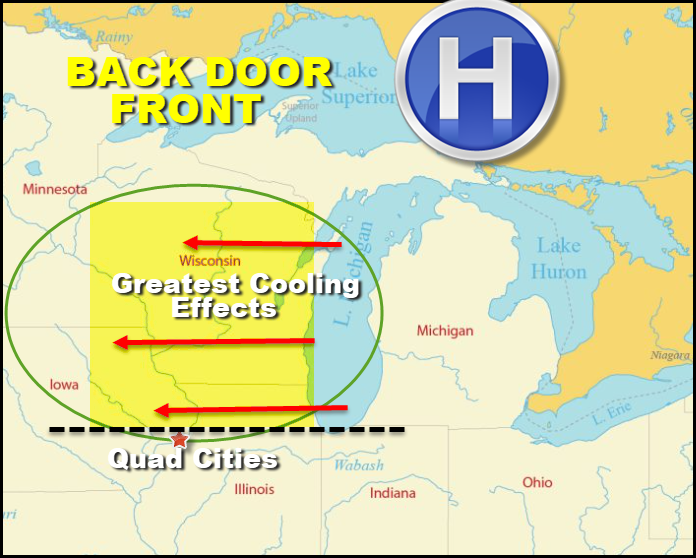
The reason is geographic. Look above at the southern tip of Lake Michigan and you can see any strong fetch of east to northeast winds will force cooler air inland that can reach as far west as eastern Iowa, northern Illinois, and much of Wisconsin. Due to the southern extent of Lake Michigan and the trajectory of the east wind, the cool air tends to be most pronounced north of I-80. I've seen days where southeast Iowa is near 70, while further north its in the upper 30s near Dubuque and HWY 20. The cold dense air blocks the northward extent of the approaching warm air. Or, due to its density, drives it up and over the shallow cold air where its warmer two thousand feet up than at the surface. That's what's called an inversion.
Below you can see that only 43 percent of the Lakes have ice cover. However, water temperatures are frigid, barely above freezing in the low to mid 30s.

In fact, ice coverage on Lake Michigan is below normal with coverage just over 20%.

So, you have cold water to hinder warm-ups and a pretty healthy snow cover, especially over northern Wisconsin and Michigan to chill the air above it even more.

You can see the effects that had on temperatures late Thursday afternoon.

So far, it's acted as a block holding some very mild air just to our west and south. That's what I call the "wall of shame" since it truly is a shame we've struggled to get into that. Below are the late day temperature departures from normal Thursday. We finally got a taste of what's to come.

Going forward, just how mild we get will be tied to thr strength of the jet and the direction of our wind. The next few days wind fields will be fairly light which is not great for transporting the warmth to our southwest. On top of that, a storm will be passing to our south producing rain in the lower Mississippi River valley. That keeps the overall air mass there cool, hindering readings from warming here until that system passes.
Due to the reasons I just mentioned, readings should remain fairly consistent through Saturday. That implies highs of 50-55 north to south Friday and Saturday. Sunday and Monday, the the ridge amplifies a bit allowing a bump into the range of 58 to 62. After that a storm is shown developing to the southwest that turns winds to the east southeast and the backdoor front slips south Monday night.
That's a game changer and come Tuesday the whole area seems to be relegated to highs in the low 40s north to the low 50s south. Just a few days ago the model expectation was 65 to 70. I'm on the record for saying that those numbers were highly unlikely. We can give an assist to the Great Lakes for that.

Finally, we may even see some rain in the north Tuesday night as the system to the SW rides the thermal boundary laid out over the northern Missouri border. Once again, the bulk of the precipitation is shown in Minnesota and Wisconsin where some of it will be in the form of snow.
By the way, the GFS is further north with that system and brings a warmer day Tuesday with highs in many areas in the upper 50s to low 60s. Personally I believe all the cold dense air will force the more southern track of the EURO and thus I currently prefer its far colder readings Tuesday. The wall of shame effect.
The storm track the 16th to the 24 at 500 MB looks like this on the EURO. You can see multiple rounds of energy kicking out of the mean trough over the west. That implies several potential weather makers in that time frame. Where they track will have serious implications on temperatures, precipitation type, and most certainly precipitation amounts.

We should be in the think of the baroclinic boundary where storms travel, not far from the cold or warm air. With any system, the area could end up in the cold or warm sector. It's too far out to get cute with that. One trend today that we can't get around, despite such an active pattern, is getting into the sweet spot for any system to produce heavy precipitation locally. Here's the total qpf shown on the EURO and GFS the next 15 days and the black hole is east to pick out over Iowa. It seems wet everwhere but here! It wouldn't take much of a shift to get us in the money, but this trend has consistently shown up over the past week. Fingers crossed things change as we need the moisture.
The GFS

The EURO

So far 2026 precipitation has amounted to .59 inches at the NWS in Davenport, Iowa. Most of that fell in a single day.

In Dubuque, only .05" has fallen the past 26 days including today. Man, that is ugly.
Today will be another dry day, but aside from that it will be a humdinger. Lots of sunshine and 50s. Soak it up and roll weather...TS ON A SERIOUS NOTE, IF I CAN'T MEET MY FINANCIAL GOALS, THIS WILL BE THE LAST YEAR OF THE SITE. IF YOU LIKE THE CONTENT, THE FUTURE IS UP TO YOU. T.S. 78% to my goal.


Comments