


THAT'S LOOKING MORE LIKE IT...
- Feb 12
- 2 min read
A SPECIAL MESSAGE, I need your help to fund the site

I would like to thank the 280 amazing people who have stepped up to the plate and made a donation to fund the site through this December. In the past year, TSwails had over 600,000 sessions, meaning less than 1 donation per session. If you do not find value in the site or don't have the funds, I understand and still welcome you with open arms. For those of you here daily, who gain knowledge, or make financial decisions based on the information, I ask that you make a reasonable contribution. Every little bit helps. After much deliberation, I've decided that due to the daily commitment of time, money, and hard work, this will be the last year for the site if I don't reach my financial goal. I'm 76 percent there. The future depends on you. Thank you for your consideration and support the past 13 years. T. Swails
LOTS OF WEATHER ON THE TABLE
It seems like forever that I started talking about this pattern change that is going to bring some wild swings in our weather the next 2 weeks. The most obvious change initially was the warmer temperatures that would come our way. Well, with the storm track morphing into this next Tuesday, we are definitely on track for a spring preview.

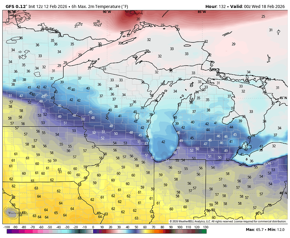
As early as Sunday and Monday highs of 55-60 are on the table. However, I have seen some signs that the old back door cold front will snip off the warmth about the time it gets started Monday night, especially in the north. The EURO definately shows that potential with highs Tuesday that look like this.

The GFS is warmer but exhibiting that trend. Not to say these are bad temperatures, they are just cooler than indicated a few days ago. I've gone over why this trend was likely a number of times, so I won't beat the poor horse again.
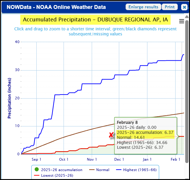
One of the aspects of our long-range forecast I'm focused on is whether we can come out of this western trough structure with some beneficial precipitation the next 2 weeks. That is something we sincerely could use. Since August 15th, only 6.37" of precipitation has fallen in Dubuque. Normal is 14.61, meaning the key city has built a deficit of 8.25 inches. That is the lowest on record for that 6-month period in Dubuque!
This morning's GFS shows promise with a 15-day precipitation outlook that is quite generous. Take a look.

On the other hand, the EURO still has that black hole over the area with ample precipitation north and south.

Unfortunately, the question of beneficial precipitation remains unanswered locally. However, with this trough still out there on the 22nd of February, there is plenty of energy available to pull it off, so I'm not ready to throw in the towel. If somehow we don't, it will be a waste of a very promising set-up.

Well, that's all I have time for at the moment. Thanks for checking in and roll weather...TS ON A SERIOUS NOTE, IF I CAN'T MEET MY FINANCIAL GOALS, THIS WILL BE THE LAST YEAR OF THE SITE. IF YOU LIKE THE CONTENT, THE FUTURE IS UP TO YOU. T.S. 76% to my goal.


Comments