


TO SNOW OR NOT, A FRESH TAKE...
- Jan 29, 2022
- 5 min read
LAST CALL FOR WEATHER SCHOOL. TSwails.com is offering a very special opportunity for you to learn first-hand the ins and outs of weather forecasting with one of the most experienced meteorologists in the country and a talented team of experts. Get the agenda, details, and limited seats by clicking the banner below.

WHITEOUT
The eyes of the weather world will be focused on New England Saturday where a powerful nor'easter is expected to plaster the area with up to 30" of snow and hurricane force winds of 50-70 mph. I can't even imagine a storm like that. Talk about a dream blizzard, that would be it for me. Boston will be near the epicenter of the system but even New York could get up to a foot. Below you can see blizzard warnings from Long Island to Boston and on up the Maine coast.

Here's the snowfall forecast. Snowfall rates of 2-4" per hour and totals of 24-30"! Man, that's as much snow as we average in an entire winter.

Out on the cape, some winds could actually exceed 80 mph. If this things lives up to its billing this will be a shut down blizzard with some drifts of at least 10 feet. Oh boy, do I wish I was there to take it in. I'm fired up just writing about it!

To my friends in Portland, Maine where I spent last winter, I raise my snow shovel to you...

OUR OWN SNOW AND COLD NEXT WEEK...
As you know I've been trying to get a handle on a winter storm that will impact the central Midwest around Wednesday of next week. Late Friday the Weather Prediction Center outlined much of my area as a candidate for heavy snow in its day 3-7 hazard outlook. I SAY NOT.
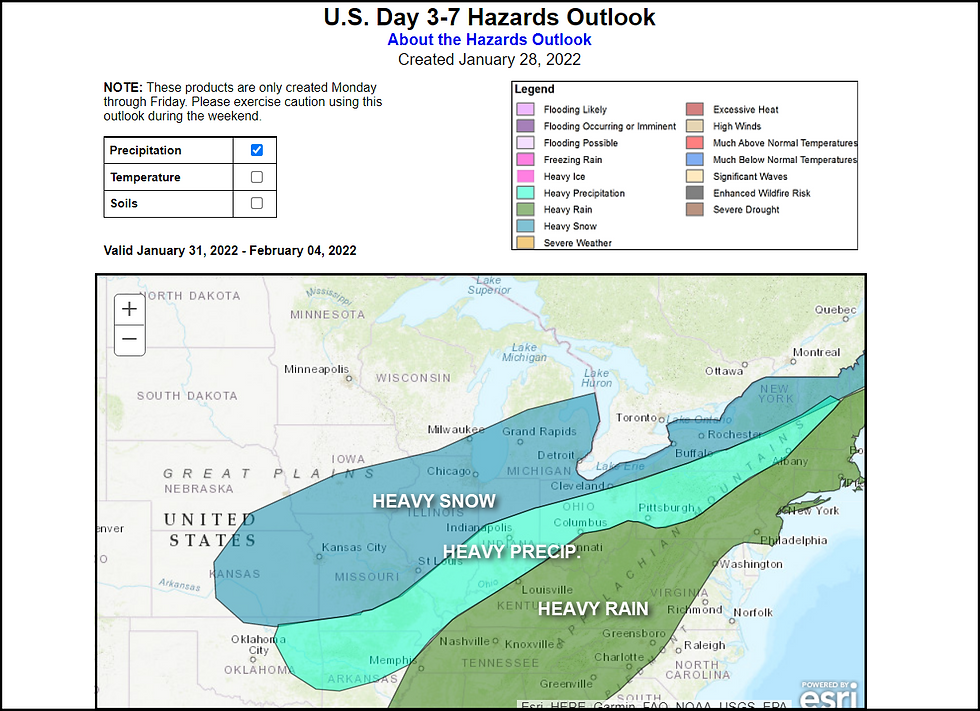
Following the storm WPC also shows the central U.S. at risk for much below normal temperatures late next week. I SAY YES. I will get to that after we discuss the snow scenario.

TO SNOW OR NOT TO SNOW, THAT IS THE QUESTION
The period Saturday through Tuesday appears pretty straight forward and dry so there's not much to say there aside from the fact the weekend will be seasonally cold with highs generally in the 20s, perhaps the low 30s far south on Saturday. Monday with a little warm advection, highs should reach the low 30s north to low 40s south of HWY 34. Monday night readings hold fairly steady until a cold front makes its move through the area early Tuesday turning winds to the north allowing temperatures to cool once again. The push of this front and the depth of the cold "dry" air will play an important role in what looks to be a significant snow event for some part of the central Midwest Wednesday/Wednesday night.
The aformentioned cold front stalls out south of the area as it encounters a strengthening feed of moisture drawn northward by a deepening western trough. Wednesday, near and north of the front warm moist air overrides the deepening Arctic airmass allowing the development of widespread snow. Models have come into better agreement on the progression of key synoptic features. That said, important differences remain regarding how far northwest the snow shield develops due to the amount of dry air building south behind the front.
Since this appears to be more of an overrunning event without a classic surface low, it's quite possible the building Arctic high could have the force to eat into the northern edge of the precipitation shield and drive it further south. It wouldn't take much of a shift southward to limit the push of snow into my region. In fact, we could miss it altogether. That said, some place in the Midwest is going to be subject to robust mid-level frontogenesis for a lengthy period of time leading to some very hefty snowfall totals.
The lack of phasing troubles me and has me wondering if today's models (which have pushed the snow shield further north into my area) are too aggressive with moisture and snow totals leading to what would be a miss. Since we're still 4 days away I could easily see this going further south than what's currently shown. On the other hand, if there's more phasing in future runs with at least a weak surface low, I could see a band of snow catching my area. However, that trend has not shown up yet and I think chances are minimal that it will. For certain, if any part of my area sees accumulating snows its my southern counties.
Be that as it may, here is what the GFS and EURO are depicting for snow totals early in the game. These are not forecasts, just raw model output good for ascertaining trends.
The EURO

The GFS

I guess the bottom line on the snow for me tonight is that I am not ready to bite on any solution just yet. Data should start to improve over the weekend and hopefully shed more light on the situation leading to higher confidence.
HOLD THE PHONE, THIS JUST IN...
I was ready to push this post and the new EURO just came in. Guess what, my concerns were realized. Look at its southward shift with the snow band. The cold dry air is pushing and winning the day. I would not be surprised to see this go further south in coming runs. The GFS will need to play catch-up if my suspicions are correct. I think barring a major change, this could very well end up being a cold nothing burger for my area when it comes to snow. I hate cold nothing burgers!

COLD, COLD, AND MORE COLD After this system clears the door is open to Arctic air once again. In all honestly, the pattern reverts back to what we've seen consistently since the 1st of the year. That includes plenty of NW flow and regular cold fronts delivering below normal temperatures. Such a pattern contains limited moisture and precipitation chances are tied to fast moving clippers. Overall, a rather dry and cold look to the first 2 weeks of February. Here's the 10 day temperature departures February 3-13th. Notice most of North America way below normal! No signs of spring there.

With that, I'm looking longingly at Boston and wishing I could get a sniff of that beastly storm. Unfortunately I will live it through the eyes of the Weather Channel and Jim Cantore. A comfortable but less appealing option. Enjoy your weekend and roll weather...TS
PLEASE CONSIDER SUPPORTING TSWAILS...

Hi everybody, I'm asking that those of you who find value in the site to consider a $12 dollar voluntary subscription covering operating expenses and the time and effort I put into the site. My $12 dollar asking fee is the cost of a pizza or a dozen donuts. Those are gone in a day, TSwails.com is here for you all year long. It's a heck of a value and all I'm asking is that if you enjoy the site and see value in it, that you please consider a voluntary subscription. I'm asking $12.00 dollars a year. That's $1 dollar a month or 3 cents a blog. Thank you for your support and consideration. Terry


Comments