


WHAT GOES UP MUST COME CRASHING DOWN...
- terryswails1
- Jan 18, 2022
- 5 min read

LAST CALL FOR WEATHER SCHOOL TSwails.com is offering a very special opportunity for you to learn first-hand the ins and outs of severe weather forecasting with one of the most experienced meteorologists in the country and a talented team of experts. Get the agenda, more details, and limited session seats by clicking the banner below.

WHAT GOES UP...
You all know the old saying, what goes up must go down. Well, we'll see positive proof of that once again with our temperatures the next 36 hours. The roller coaster is locked, loaded, and driven by a clipper (which as clippers do), will streak across the upper Midwest Tuesday. You watch the evolution of the system in the animation below that ends Wednesday morning.

The track through Minnesota and Lake Superior keeps the snow threat well to the north of Iowa. However, the counter-clockwise circulation ahead of the advancing surface low draws mild air into the central Midwest Tuesday. Highs are likely going to reach well into the 30s (above freezing). Were it not for the existing snow cover. readings would have a good chance of climbing into the mid 40s, maybe even 50 in the south. As it is, the EURO indicates highs that look like this Tuesday. Warm enough for some melting snow...

We remain in the mild air until about Midnight Tuesday night when an Arctic cold front tied to the clipper comes barreling southeast. In the meteogram below you see that at that time the temperature falls 20 degrees from 31 at midnight to 11 at 8:00am Wednesday morning. By then winds are gusting to 30mph and wind chills are in the range of 5 to 10 below zero.

As the cold continues to deepen lows Thursday morning will likely go below zero in much of my area, perhaps as cold as 10 below in my NW counties. This is what the EURO indicates.

Wind chills around daybreak Thursday will be in the range of 15-25 below, coldest in my Iowa counties. Wind chill advisories are a given.

That's followed up by very cold days Thursday and Friday with highs only in the single digits and lows again Friday morning near zero in the SE to 15 below in the NW.
Overall the weather looks to remain quiet until Friday night or Saturday when the first in a series of relatively weak disturbances may bring some light snow to the area. The first is slated to arrive late Friday night and Saturday morning. The forcing with this system is broadly stretched and moisture looks limited so snowfall is not likely to amount to much more than a dusting to 1/2 inch.
The second system appears to be better organized and has all the trimmings to be classified a potential clipper. It's due in Sunday night or early Monday. The track with this disturbance will be critical as clippers in general don't have wide snow bands to begin with. Thus, a little shift in its path could mean a whole lot of nothing or a 1-3" snow. At this distance confidence is low as to the overall impacts but it's really about the only thing that amounts to much over the next 6-10 days.
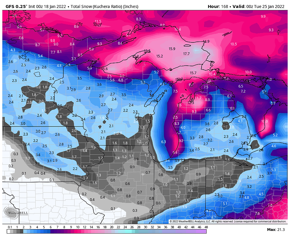
Just to show you the initial trends regarding Sunday nights snowfall, here's what the EURO, GEM, and GFS are indicating. By no means is this a forecast, it's just the initial stages of what could be a concern in the long term. Right now it's just like a mosquito buzzing away on a summer day. Until it lands it's causing me no problems, (but I've got my eye on it in case it does).
The GFS
The EURO

The GEM

THE NEXT 30 DAYS...
I was just looking at some of the long range teleconnections and the EURO certainly has the makings of a wintry 30 day period ahead. The AO (Arctic Oscillation), NAO (North Atlantic Oscillation), EPO (Eastern Pacific Oscillation), and WPO (Western Pacific Oscillation) on the EURO ensembles are all shown going into cold phases. The PNA (Pacific North America Oscillation) is going from a positive phase to one that is slightly negative. That implies that the big eastern trough is likely going to retrograde, weakening the existing east coast trough and forcing it westward. That would allow future troughs a better chance to amplify and pull moisture into the Midwest in the 10-30 day period. With all the other cold signals in place, even if the trough goes all the way to the west coast, the cold dense air will push putting the Midwest in a position to experience a cold snowy pattern.
After that eye opening experience, I went to the EURO weeklies and boy did the control run follow through with that idea. Here's what it shows for temperature departures the next 30 days out to February 18th. These are big daily departures over a 30 day period.

Then I looked at the 30 day snow totals for the same time frame and the whole northern half of the nation is buried. My area in particular was positioned to see some of the heaviest amounts.

Overall, this was a heck of a run for winter over the next month. As always, I put far more faith in the temperature outlook than the snowfall totals but if you just play the trends, cold and snow are front and center. There is always the danger that the model could be wrong and we get a much less severe result than shown. For that reason, I stress this is just a model forecast who's benefit is showing us the road that "could" lay ahead. In a general sense, I suspect some derivative of the above pattern is coming and that would be fine by me. I do think if it happens, the snowy part of the next 30 days won't arrive until the end of January and the following 2-3 weeks of February assuming the mean trough moves further west. If nothing else, there's plenty of potential on the table.
With that in mind, I would encourage you all to enjoy the friendly demeanor of Tuesday's weather. It's mean old ugly sister will pay us a visit in short order. That's all I've got for now. Roll weather...TS
PLEASE CONSIDER SUPPORTING TSWAILS...

Hi everybody, I'm asking that those of you who find value in the site to consider a $12 dollar voluntary subscription covering operating expenses and the time and effort I put into the site. My $12 dollar asking fee is the cost of a pizza or a dozen donuts. Those are gone in a day, TSwails.com is here for you all year long. It's a heck of a value and all I'm asking is that if you enjoy the site and see value in it, that you please consider a voluntary subscription. I'm asking $12.00 dollars a year. That's $1 dollar a month or 3 cents a blog. Thank you for your support and consideration. Terry


Comments