


WHEN IT RAINS, IT WILL POUR
- Jun 23, 2025
- 3 min read

Good evening everyone!
First off this post is a little later than normal if you a checker of the website late at night. I provided the upper level wind weather support for the SpaceX Starlink launch from Florida at a late 1:58 a.m. eastern time.


The bright side? I get the full suite of model data to peruse through to break down the very active weather pattern ahead, and that starts today (Monday)!

Monday looks very active in terms of a heavy rain/flooding risk as well as severe weather including damaging wind gusts. A tornado or two is also possible although somewhat unlikely. Starting off with the probability-matched-mean product from the HRRR, there is a strong indication of some hefty rainfall totals from northern Kansas into southwest Wisconsin between 7 a.m. Monday and 7 a.m. Tuesday. Pockets of 3"+ are certainly possible with training thunderstorms (storms that hit the same places over and over again).

In the evening hours Monday, storms are likely to be strong if not severe. Most convective models are indicating strong updrafts that can correlate to severe weather. For the Quad Cities region, the highest severe weather risk will likely be just to the west/northwest. In Iowa, the highest severe weather risk is likely a line from Red Oak to McGregor (Prarie du Chien, WI), including the Des Moines and Waterloo metro areas.

The latest Storm Prediction Center outlook highlights this area rather well with a broad-brushed Level 2 of 5, Sligh Risk, for the region. The Quad Cities are in the Level 1 of 5 risk, a Marginal Risk. Again, the main concern with the strongest storms will be damaging wind gusts.

Models are indicating thunderstorm development around 1 p.m. with storms continuing to develop and intensify through the evening hours. Storms capable of strong wind gusts and heavy rain will persist through at least 1 a.m. in the region before waning late.

Models are really zeroing in on the intense moisture available for heavy rain Monday. Precipitable water values are forecast to be at a record for the date and time in central Iowa. PWAT values well over 2" are increasingly a problem meaning heavy thunderstorms may produce rainfall rates of 2"+/hour.
The Canadian Ensemble

The American Ensemble

The European Ensemble

Going through the rest of the week the pattern will remain quite active with a boundary stalled out over the region, but day-to-day rain chances have lower confidence and skill due to the impact the preceding day will have on the location of the boundary. For the Quad Cities region, rain chances are elevated certainly, but I do think the highest rain chances will likely be northwest, especially eastern Nebraska into central Wisconsin. The ensembles from the major weather models are all in pretty great agreement with the location and values through Friday evening.

For what it's worth, the Storm Prediction Center has a Level 1 of 5 risk, a Marginal Risk, blanketed across the region Tuesday. The potential is certainly there for storms, but given the lack of confidence in the "where," this seems quite justified to be a heads up for the potential. There is a high likelihood this will change in future updates.

The severe weather risk will be present almost daily into the upcoming weekend due to the heat and humidity in place. The Quad Cities will be flirting with 90° air temperatures and triple-digit heat indices every day. There will be a lot of fuel for not only thunderstorms, but strong storms. The good news? We will go from really uncomfortable air to just uncomfortable air by early next week with a BIG COOL DOWN into the... mid-80s.

Analogs are also hinting at some "cooler" temperatures heading into early July. Might make Fourth of July plans perhaps a little more tolerable outdoors.

In fact, the probability of 100°+ heat indices June 30-July 3 is only about 30% for most of the region. That's promising, and certainly something to look forward to.
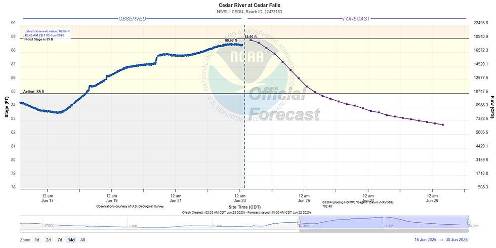
I want to continue to highlight the concern for flooding along area rivers headed into early July. The Cedar River in Cedar Falls, Iowa appears to have crested just below flood stage Sunday. Note the forecast projection only takes into account the next 24-hours of rainfall, so this is not a great reflection for the week ahead, but I wanted to show is as it at least conveys the point rivers are already agitates. Heavy rainfall this week will likely help push some area rivers much higher. So again, if you have interests along area rivers including camping plans, or boating/swimming, please keep an eye on the river forecasts. Those currents are not something to mess around with as the rivers rise.
That will do it for me! Have a great week everyone! Stay cool and stay safe from the storms.
-Meteorologist Nick Stewart


Comments