


WINTER, THE PARTY STARTS NOW
- Nov 26, 2025
- 5 min read

LIVE WINTER STORM BRIEFING WEDNESDAY
Wednesday evening at 7:00, myself and meteorologist Nick Stewart will do a special Facebook live briefing on the impending holiday weekend storm. We'll give you some specifics on what models we are leaning on, timing, snow amounts, and essentially what to plan for if you are traveling.
Also, we are entering into a significant pattern change that could bring wintry weather much of December. We'll discuss the implications of the MJO (Madden Julien Oscillation) and a rare strong November stratospheric warming. We'll also talk about teleconnections and their importance to long range trends and forecasting. Of course, we'll open it up for you to ask your own burning questions. See You tonight at 7:00
LET'S GET THIS PARTY STARTED...
More than 3 weeks ago, I pointed out there was a good chance the nation would undergo a pattern change that could bring wintry weather into the Midwest around Thanksgiving. The leading indicator behind this belief was the MJO, which was expected to depart the warmth of phase 6 and cycle through the holy grail of cold (phases 7, 8, and 1 during December).

As you can see above, we depart phase 6 today, and then it's 3 to 4 weeks in 7, 8, and 1. Notice the difference in temperature analogs from warm to cold going forward. As far as I'm concerned, winter officially starts now.

Right on cue, a potent cold front plowed across the region Tuesday night producing 40 mph winds, sending temperatures tumbling. In fact, readings should remain steady or even fall a few degrees during the day, with the north holding around 30. Elsewhere, from I-80 south, highs of 34-38 are anticipated. These are projected readings at 3:00pm. This is the cold air that will set the table for snow this weekend.

The accompanying wind chills Wednesday are in the teens across the NE half of my area thanks to W/NW winds of 25-35, with gusts of 45 mph. A wind advisory is in effect for the entire area Wednesday.

Adding insult to injury will be snow showers that are likely, especially north of HWY 30 in the morning. A solid dusting to as much as a 1/2 inch of accumulation is possible, closer to HWY 20. It is not going to be a pleasant day! Snow potential early Wednesday on the 3K NAM.

Thanksgiving Day should see partly to mostly sunny skies under a passing ridge of high pressure. The day starts cold and ends cold. Morning lows will range from 20-25, with afternoon highs of 30-35 from north to south. Wind chills the balance of the day will be in the mid-teens north to the mid 20s far south. If you are planning on walking off that pumpkin pie, the big coat will come in handy.
Traveling impacts look minimal Wednesday through Friday. Aside from the winds and cold, roads should be high and dry.
GIVE THE GIFT OF MY 5 STAR AIRBNB IN GALENA

Holiday and winter specials are now in effect through March. Let us help you set up a personalized gift certificate that's sure to create a lifetime of memories! Santa Claus approved. Call or text Carolyn at 563-676-3320 for details and our very best pricing. https://www.littlewhitechurchgalena.com/
IT'S SNOW JOKE
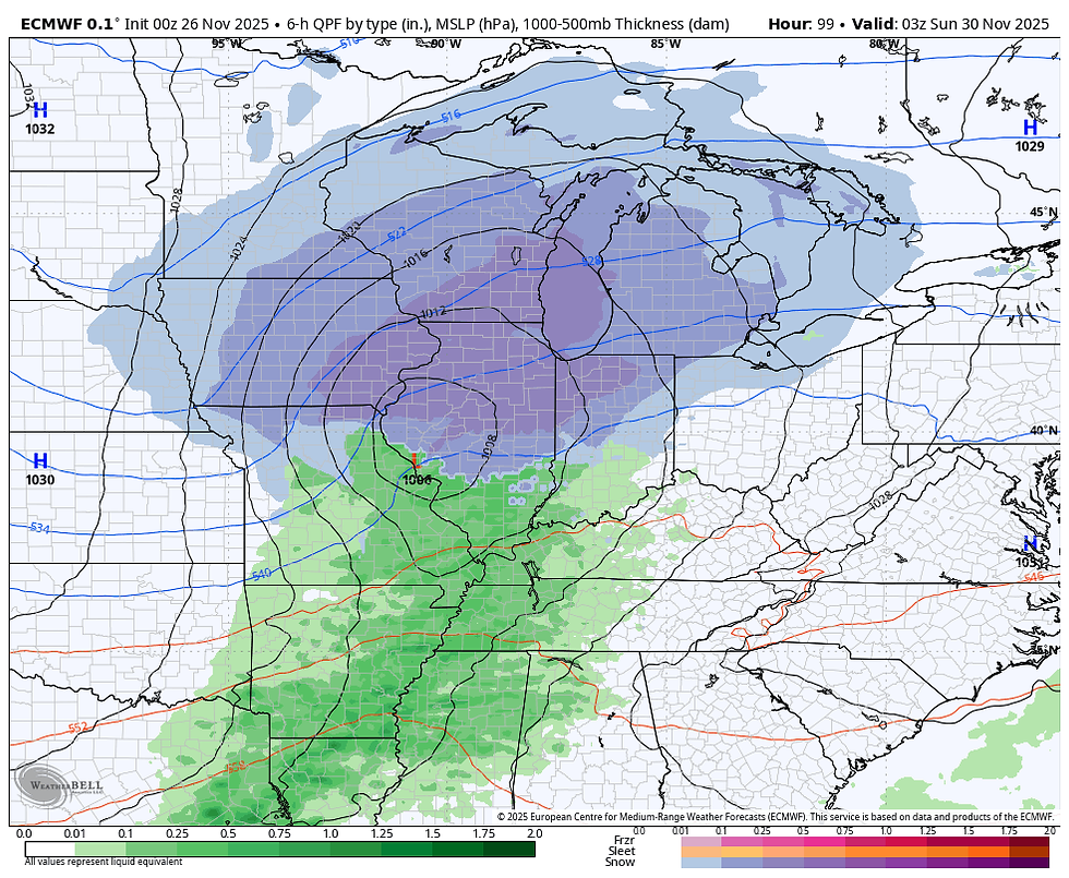
Confidence continues to grow that the majority of the area sees its first significant accumulating snow starting late Friday night and continuing until late Saturday night or Sunday morning. We've still got 60 hours to go before tip-off, so all the details are not set in stone, but there is much better agreement between the EURO and GFS of a significant system with heavy snow potential.
At 500mb, you can see vorticity (lift) carving out a strong short wave trough headed for Iowa late Saturday.

Water vapor around that time is nearly 200 percent above normal in SE Iowa. No shortage of moisture for this system

In fact, the EURO shows total liquid equivalent precipitation from the event at 1.50 inches near the Quad Cities.

That's up from 24 hours ago and an indication that the storm is deeper and better organized with the surface low and the overall storm structure. At 9:00pm Saturday night, you can see the deformation band snow extending north of the surface low situated near Quincy.
At this point, ensembles can be quite helpful as they are an average of numerous solutions that could take the storm further north or south, altering accumulations in a given spot. What we want is for the majority of these 50 or so options to show the most likely solution through an average. Here's what the EURO indicates at a standard 10:1 snow ratio. This is for the period Friday night through Sunday morning.
The EURO ensemble

The GEFS ensemble has this for the same period.

The Canadian GEM ensemble.

What we can't see with the ensembles is potential amounts with higher snow ratios than 10:1. Figuring this into the equation, both the EURO, GFS, and Canadian deterministic runs suggest significantly higher amounts. Take a look.
The EURO

The GFS

The Canadian GEM

You can see the higher snow ratios really raise the potential amounts in this particular scenario by 2–5 inches. Now, to make something very clear. There are no specific snow forecasts at this point in the game. What I have showed you is raw model output from several models. These will be instrumental in making a specific forecast when the time is right, say 48 hours. They may also lead to winter storm watches at some point. However, with some uncertainty in the track at this distance, we will continue to define potential amounts in the next 2 days. That said, chances are high that some part of my area will see locally heavy snow that could be greater than 6 inches. The Weather Prediction Center indicates a 50-80 percent chance of snow that would prompt a winter storm warning for the northern half of my area. I think that should be extended even further south.

Here you can see the general area that WPC thinks has the threat of heavy snow Saturday.

Along with the snow will come wind and cold. On the back side of the system, some gusts over 30 could certainly produce some blowing snow, especially in the NW half of my area later Saturday into Sunday morning. That ushers in the coldest air of the season so far, with falling temperatures Sunday into the teens and low 20s by late afternoon. With snow on the ground and winds diminishing, Sunday night temperatures could really tank, perhaps to sub-zero levels. The EURO shows this for lows by Monday morning. It's based heavily on a healthy snow cover, which is yet to be realized. Impressive for December 1st.

That's where we stand on the eve of Thanksgiving. Cold Turkey for sure this year. Be sure to check the winter storm briefing out on Facebook Wednesday evening. Nick and I will hit it live at 7:00, but it will remain on the page so you can check it out at your convenience all night. Roll weather...TS
TSWAILS.COM expert weather consulting services (CLICK FOR MORE)

Private consulting
Legal forensic services as an expert witness
Public speaking engagements for groups or individuals
Post storm analysis
A private day-long weather school class
Specialized events forecasts
Severe weather seminars
Lectures and training
Climatological services
Meteorological workshops.


Comments