ZIP-A-DEE-DOO-DAH...
- Oct 8, 2022
- 3 min read

Zip-a-dee-doo-dah, zip-a-dee-ay. My, oh my, what a wonderful day. Plenty of sunshine, heading my way. Zip-a-dee-doo-dah, zip-a-dee-ay. That littlie ditty from the movie, Song of the South, sums up Saturday afternoons weather. However, before we get there early risers Saturday morning may need to scratch some frost off the windows. A freeze warning is in effect until 9:00am. In the Quad Cities this is likely to be the coldest morning since April 276th when a reading of 33 degrees was measured.

We are not the only ones experiencing the chill. The entire central Midwest is covered in freeze warnings or frost advisories early Saturday.

It remains to be seen just how cold readings actually get, but the official NWS forecast below was suggesting lows in the upper 20s to low 30s around my region. As I write this Friday night there are some patchy clouds around that could keep readings 2-3 degrees warmer if they hang around long enough. At this point they are expected to dissipate leading to a frosty start to Saturday.

Below you can see in the Quad Cities the dates of the last spring 32 degree low temperature and the first 32 of the fall season since 2012.

The last 10 years the average date of the first fall 32 in the QCA is October 19th. However, we did have an occurrence as early as September 23rd in 2012.

At least for now the worst of this round of chill is behind us. The rest of Saturday will be sunny and crisp. A good day to take care of some of those fall chores. Highs will generally be in the mid to upper 50s. Sunday, return flow initiates a warming trend that lasts into Tuesday of next week. Highs will go into the range of 65-70 Sunday and Monday. Tuesday now looks to see a decent period of warm air advection that is likely to bring clouds and even a chance of rain. That should hold temperatures in the low to mid 60s Tuesday.
THE WILD CARD, A PATTERN CHANGE NEXT WEEK
Things get much more interesting for the middle and end of next week. Yesterday models had backed away from much in the way of phasing with our next system shutting the door on rain prospects. Today both the EURO and GFS show a deep 500mb closed low that really wraps up over Minnesota. You can see the side by side comparison of the energy below. The GFS on the left vs the EURO on the right.

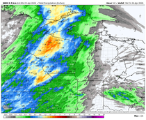
The EURO depicts a sharper trough digging further southwest. It supports a system capable of producing some decent rains.. It cranks out amounts that look like this.

It also draws in a surge of cold air that brings snow to parts of the upper Midwest.

The GFS develops the system further east and that keeps the better moisture and forcing just to the east of my area. As a result rain totals are much lighter.

While the GFS does show some snow, it remains north of my area.

If this system reaches the intensity indicated, it is going to be a big wind producer. Gusts of 40 mph+ are possible on the backside of storm next Thursday...cold winds too!

We are still about 5 days away with this event so some changes and revisions are to be expected. However, confidence is growing that a strong storm is likely over the Midwest by the middle of next week. How much precipitation falls is still up for grabs but windy cold weather appears to be in the cards. It is also possible that the first snow flurries of the season could emerge for some, especially in my NW counties should the EURO solution pan out. Plenty of time to figure that out.
Meantime, it's finally Saturday. Zip-a-dee-doo-dah! Make the most of it and roll weather...TS


Comments