
SPLASH AND DASH STORMS, WITH A SIDE OF HUMIDITY...
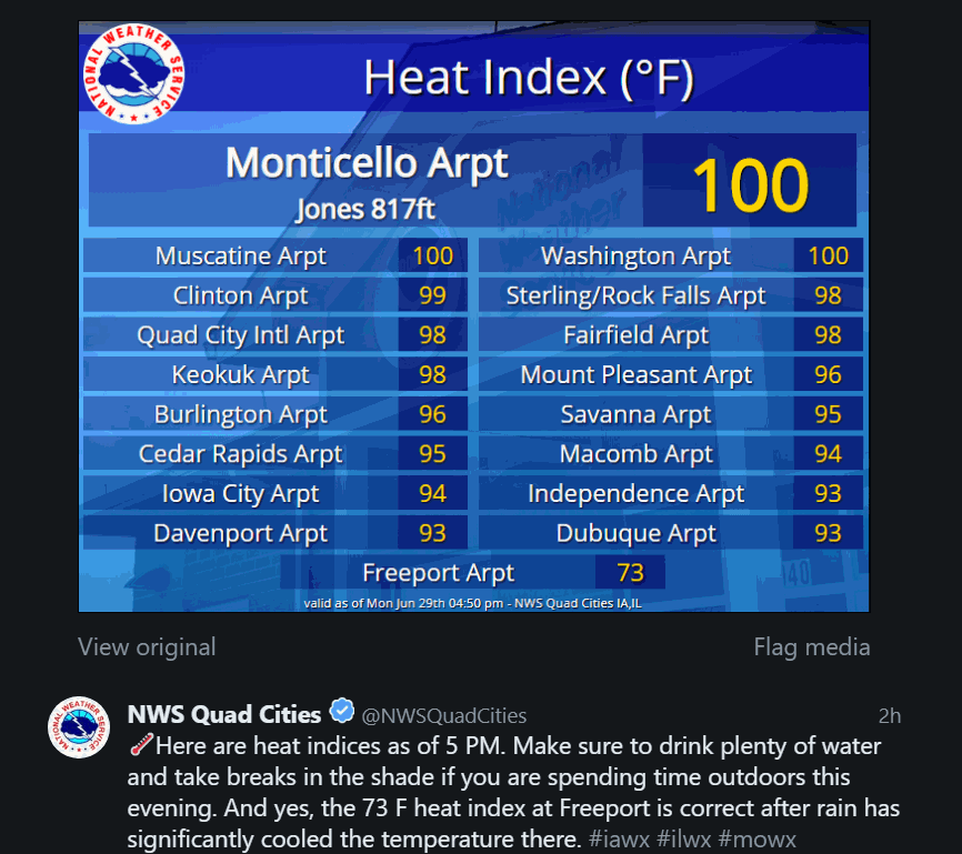
Make no mistake about, Monday was a burner. With highs in the range of 85 to 90 and dew points in the 70s, it felt more like 95 to 100. That qualifies it as a dog day of summer. Here are some late day heat index values from the NWS in the Quad Cities. With that much heat and humidity, instability was high but forcing was lacking and most of the thunderstorms avoided my local area. That was not the case where intense thunderstorms battered parts of the upper Midwest. Rainfall

RAIN FOR SOME THIS WEEK...
The heat is on and it will be a hot, humid week. It begins Monday with low rain chances and hot temperatures: Humidity will is going to be very high... dew points in the 70s is very uncomfortable. That will translate to heat index values in the 90s to near 100 degrees Monday afternoon. There will be little relief today with just a few scattered showers and thunderstorms near and east of the Mississippi. In fact, that's where most of the rain will be this week, in southeastern

IT'S NOT THE HEAT, IT'S THE HUMIDITY
Right now it's kind of both that's going to get you. But the humidity is running high.. something that's pretty typical this time of year. In order to discuss humidity we have to talk about the dew point temperature. Here's an explanation of the dew point from the National Weather Service in La Crosse: "The dew point is the temperature the air needs to be cooled to (at constant pressure) in order to achieve a relative humidity (RH) of 100%. At this point the air cannot hold m

CLOUDS SEEDED BY METEOROIDS...
Noctilucent clouds over London taken by Phil Halpert June 2020 METEOR CREATED CLOUDS IN THE MESOSPHERE In the summer of 1885, sky watchers around northern Europe noticed something strange. Sunsets weren't the same anymore. The red and orange colors people were used to seeing were still there, but those familiar colors were increasingly joined by rippling waves of luminous blue. At first they chalked it up to Krakatoa which had erupted two years earlier. The explosion of the I

UPDATE ON TODAY'S THUNDERSTORM THREAT...
Thunderstorms that developed around the region last night and this morning have largely dissipated or become widely scattered. In the wake of the storms outflow boundaries and residual moisture remain over the area. Breaks for sunshine are also developing which will further increase instability this afternoon. By late afternoon CAPE which measures instability is forecast to be significant, especially south of HWY 20. By late afternoon a surface cold front will drift into the