STEVE'S "WILD" WORLD OF WEATHER....
THE LONGEST RUNNING WEATHER SERVICE: Hindrich's first observatory on Church and Clinton Streets in Iowa City On October 1, 1875, the Iowa Weather Service began taking weather observations. It was organized by Professor Gustavus Hinrichs at the University of Iowa with 60 initial observers. Functions of this agency are largely maintained by the State Climatological Office. Iowa has the oldest continuously operating state weather program in the nation. Professor Hinrichs is also

A BUMP BEFORE THE OLD DIPSY DOO...
Tuesday was another day of cool condition around my part of the central Midwest. Clouds were strung out from north to south around the back side of an upper air low spinning through Illinois. That kept temperatures in the low 60s and for good measure a few pop corn showers played around with little in the way of impact. Energy diving south in the NW flow aloft will continue to deepen a trough the next 72 hours that encompasses much of the central and eastern U.S. Here's the

COOL IS THE NEW RULE....
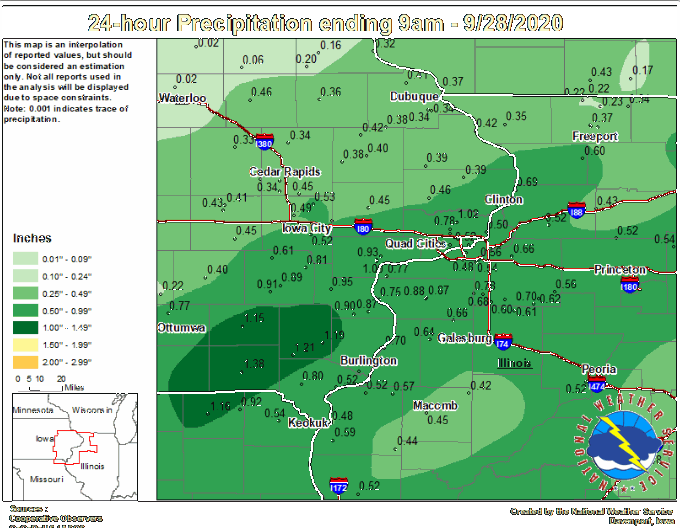
That front that came through the Midwest Sunday is re-aligning the jet and that is already leading us into a much cooler weather pattern that lasts into the coming weekend. The cool air also brought some much need rain to parts of the area. Unfortunately not everybody got in on the act. Here's some of the totals reported by the NWS in the Quad Cities. You can see it was the southeast half of the region that enjoyed the higher totals. Northwest of a line from Omaha to Waterloo

FIRST FROST POSSIBLE LATER THIS WEEK...
Cooler air has now settled in as a cold front moved across the Midwest Sunday. Here were the temperatures around 6 pm Sunday: The new week will be very fall-like. Temperatures will be near and below normal in general. Monday starts: On the backside of Sunday's front some wrap around moisture may lead to scattered showers breaking out throughout the day Monday: There will be more sunshine Tuesday and Wednesday and temperatures will be in the 60s both days: A cold front will mo

A FALL CHILL ON THE WAY....
A fall chill is on the way as we head into the new week. First we have a cold front to get through. Ahead of the front temperatures got into the 70s and 80s Saturday. However it did not get as warm as anticipated due to the very thick smoke in overhead. The smoke was leading to a red tint to the sun the entire day and did hold back temperatures some. Regardless, a cold front will move through Sunday and bring the chance for rain. Rain will begin in Iowa in the late morning Su