
COOL, THE NEW RULE...
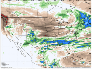
It's been in the making now for nearly a week, and finally, going forward a cooler drier weather pattern will dominate the central Midwest. The infra-red satellite confirms the fact the sub-tropical jet with all its moisture, has been shunted southward running from California through Texas into the Gulf Coast states. That's forced the active thunderstorms that have been roaming much of the Midwest to shift to the south and decrease in coverage and intensity. What scattered pr


WET, BUT FAR FROM WILD...
From the University of Iowa Cardiology floor in Iowa City, here's wishing everybody a fabulous Tuesday. The dissapointing news on my part, is that I'm back in the hospital due to complications from a bacterial desease and a couple of damaged heart valves. My medical team is diligently working on a plan to get the bacteria out of my blood stream and repair the bad valves, before a clot can break free and find a home in my brain. I'll have more on a specific course of action wh


TRACKING A REGIONAL SEVERE OUTBREAK MONDAY
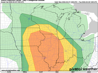
Monday continues to look ominous across the Upper Midwest with severe weather likely, but significant questions remain on how early-day thunderstorm activity will impact the severe weather potential this far north. As I mentioned last night outflow from the morning activity likely will send stable air down towards the St. Louis metro before we see a surge of southerlies recovering the atmosphere. The magnitude of instability that builds back in is questionable - and that is c


MONDAY'S SEVERE WEATHER RISK
The active weather pattern continues across the region with Monday looking increasingly concerning for severe weather potential, but there are several potential limiting factors that makes this far from a slam dunk forecast. As of now, a Level 3 of 5 risk, an Enhanced Risk, is in place for eastern Iowa, virtually all of Illinois and the eastern half of Missouri. Large hail, damaging wind and tornadoes are all possible. Modeling Saturday night is showing widespread thunderstor


IT'S GOING TO BE A FIGHT...
To begin with today, I wanted to express my deep and sincere gratitude to all of you who have taken the time to send your well wishes and prayers for a full recovery from the health issues I am facing. I have felt your compassion, hope, strength and determination that comes with them. Please know, what a remarkable gift your sentiments are, and the inspiration that comes to me with each and every one. I'm incredibly blessed and thank you all for pushing me forward to meet thi


