


MONDAY'S SEVERE WEATHER RISK
- Apr 26
- 2 min read

The active weather pattern continues across the region with Monday looking increasingly concerning for severe weather potential, but there are several potential limiting factors that makes this far from a slam dunk forecast. As of now, a Level 3 of 5 risk, an Enhanced Risk, is in place for eastern Iowa, virtually all of Illinois and the eastern half of Missouri. Large hail, damaging wind and tornadoes are all possible.
Modeling Saturday night is showing widespread thunderstorm activity across the area daybreak Monday. This has a pretty good chance of limiting the severe weather threat for the northern portion of the outlook area if there is not significant recovery by late afternoon.
These storms early Monday could produce some strong wind gusts and pockets of large hail, but this will mainly be a rain threat. Storms should be moving pretty quickly so a major flash flooding concern is not likely.
Farther south, along an outflow boundary that develops, training thunderstorms could be more of an issue for flash flooding bug that looks like a northern/central Missouri issue.

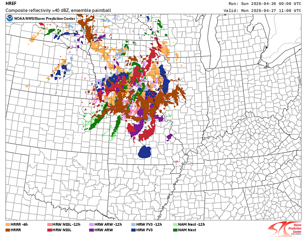
The latest HRRR shows the remnant outflow boundary from the morning activity as far south as St. Louis with some attempted recovery pushing into south-central Iowa by 3 p.m. It's a narrow area of instability which may therefore limit the severe weather potential. Across northern and central Illinois there's considerable stable air. If this is how Monday play's out the area may have a limited severe weather threat and more of just a rain/storm threat.

By 7 p.m. Monday evening a few thunderstorms are forecast to move through the Quad Cities region with mainly a wind and hail threat, but again the environment at this point may not have the recovery needed.
Meanwhile farther south towards St. Louis and into central Illinois there is looking like a pretty major threat for severe weather. Areas that do recover the instability will have ample wind shear to work with. If storms remain more isolated opposed to a line of thunderstorms, this would favor very large hail and tornadoes. The HRRR is a little more linear with some clusters of supercells. This would somewhat limit the tornado threat, but again the environment is very supportive if significant severe weather if the instability recovers.
It's a complex forecast that will have potentially major changes over the next 36 hours as the picture gets cleared following the storm passage. Unfortunately we may not really know the true scope of the severe weather threat until Monday morning following the early-day storm activity.

The latest forecast shows some heavy rain potential in the area of 1.0" to 1.5" through Monday evening. This however could be heavier if the do see recovery of the environment and more instability with late afternoon and evening severe storms.
Bottom line a complex forecast is evolving and the picture is still not completely clear. Showers and storms are likely early Monday morning, some potentially strong. The afternoon threat is dependent on recovery following the morning activity.

Following Monday's severe threat the pattern takes a prolonged break as we pivot to a cooler and drier weather weather as northwest flow takes over. This should bring some calmer weather through the first week of May.
-Meteorologist Nick Stewart


Comments