


MIND BOGGLING STUFF...
- Apr 9, 2018
- 2 min read
Wow, this has been some stretch of weather. I was trying to put into perspective just how impressive it's been and I came across this. The low temperature in Stambaugh, Michigan (just across the Wisconsin border) Sunday morning fell to 24 below zero. If verified by the NWS that is the coldest April temperature ever recorded in the state of Michigan. Not only that, it broke the previous record by 7 degrees! Holy cow, that's mind boggling to me.

So far this month there have already been 1681 record cold lows and highs established across the country. Here in Cedar Rapids the average April temperature is running 17.2 degrees below normal per day. Here's the national temperature departures for the month.

By Tuesday morning temperatures in the teens are likely over much of my area. That means records are again possible. Here's a few in my region that are in jeopardy.

Long time NWS coop. observer Steve Gottschalk (59 years of records in Cedar County, Iowa) sent me this Monday. We are up to 51.2" of snow for the season now. Since Jan. 1st we have had 43.8" of snow our 4th highest total in my records. Our March-April total is 25.8" which is our greatest in my 59 years of record. We had a record low of 13 sunday morning.
These are the snow totals across Iowa Sunday through Monday. Some 9" amounts in North Central Iowa.

28.5 percent of the country was covered by snow Monday morning April 9th. January 28th only 27.7 percent of the nation had snow cover. That my friends is simply astounding and a true testament to the strength and rarity of this wintry cold snap.

While this is not the end of the cold this spring, it does appear the central Midwest is in for a brief break. A powerful storm is expected to wrap up over the Plains mid-week forcing strong southerly winds and warmth northward. The GFS shows this Friday at noon.

The EURO looks this way for the same time period.

This promises the warmest temperatures of the year so far in my area. I think readings have a chance of hitting the 60s Wednesday and Thursday and 70s are a distinct possibility Friday. The EURO has highs Friday that look like this. Check out the 80s in western Iowa!

Moisture is also increasing with dew points expected to reach the 60s.

With the strong Plains storm entering the picture and warmth and moisture in place, instability will be sufficient for thunderstorms, some of which could be strong from Iowa into Kansas and Missouri. CAPE values of 2400 J/kg certainly point to that potential. Timing will be critical.

The CIPS severe weather analogs show some high odds with this set-up over Iowa.

The late week storm promises to be a wet one as well. The EURO has this for total precipitation. Very heavy amounts in the upper Midwest.

Here's a closer perspective.

There's a snowy side too with the EURO depicting some whopping snow totals over the upper Midwest.
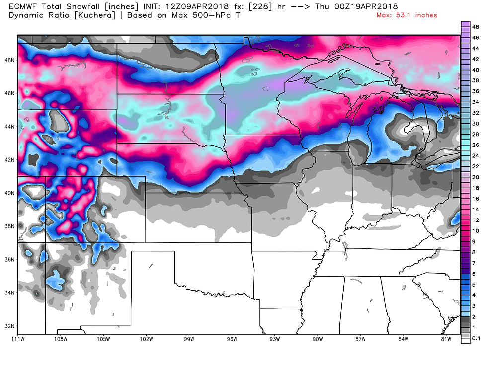
A tighter view.

To summarize, the next 2 days look quiet and warmer, especially Wednesday. Temperatures get even warmer Thursday and Friday but thunderstorm chances enter the picture. Saturday the party is over and temperatures crash once again. Snow showers return to the forecast Sunday! You name it, we got it. Roll weather...TS


Comments