


THE HEAT COMES BACK... AGAIN
- Jul 8, 2018
- 2 min read
It was a weekend full of chamber of commerce weather around the Midwest. It was still warm in the afternoons, but the humidity was low and there was not a cloud to be seen.

Of course, this nice weather was not going to last in July. Temperatures will be warming up and humidity will be going up as the new week begins.
July has already started off toasty with temperatures running near and above normal.

The killer this summer has really been the humidity. Dew points have been high and combination of warm temperatures and high humidity has lead to heat index values running 10-20 degrees warmer than the actual temperature.
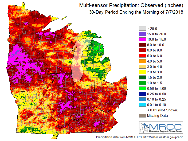
The higher humidity has also lead to some heavy precipitation events across the Midwest this summer. This is a look at the last month of rainfall across the Midwest. Woof.
Luckily, even though the humidity will be going up this week there isn't going to be much in the way of precipitation during the first half of the week. There will be some rain around northern Minnesota Sunday night and Monday, then higher chances further south during the second half of the week. Here's a look at the 7 day precipitation from the GFS and European models -


There are some differences, but in general there doesn't look to be incredibly heavy rainfall (with the exception of some portions of northern Minnesota). The heat will be back, though, starting on Monday and lasting through the week.
Monday's high temperatures -

Humidity will be back up too - dew points this weekend were int he 50s and 60s and next week they'll look more like this...

That will lead to heat index values in the 90s and near 100. Here's the expected feels like temperatures on Monday -

And the dog days of summer continue....
RK


Comments