


WHO'LL STOP THE RAIN....
- Aug 29, 2018
- 2 min read
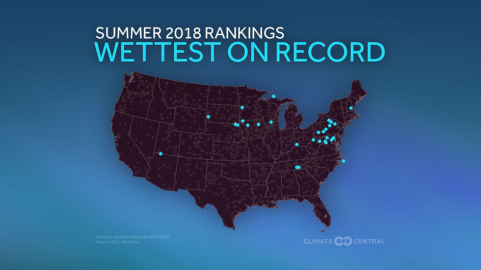
Don't look now but over much of the northern half of the Midwest this is turning into a wet summer (June- August). In fact all of the stations below are currently experiencing one of the top 10 wettest. That's quite a bit or real estate.

These stations will have their all-time wettest summer.
When you look at the entire Midwest this is what you get for summer rainfall totals as of June 28th.

A tighter view centered on Iowa. The state range from 25.48" to 8.05"" in less than 25 miles.

Here's the summer departures.


August has been wet in my local area and much of the region north of I-80.

Once again the range in totals was extreme in Iowa from 12.16" NC to 1.87" SE.

Here's your August departures.


A remarkable event just took place in SE Minnesota and SW Wisconsin where 12.66" of rain was recorded near Cashton, Wisconsin and the Dells measured 12.44". Most of that was within a 12 hour period. An added note, Cashton just missed the the all-time Wisconsin 24 hour rainfall record.

One good thing about all the moisture is that the corn crop is a good one in the majority of the heartland. The green line below from the USDA shows the percent of corn in poor to very poor condition. The amount in Iowa and Illinois is less than 10%. It's a different story in Missouri where 48% of the state's corn is in bad shape due to drought.

The recent wet weather that's dominated much of August has been caused by the placement and strength of the Bermuda high. Notice how the circulation keeps the moisture flowing into the central U.S. establishing a late season ring of fire. Here's the jet stream flow Labor Day.

Note to how water vapor (PWAT's) on the periphery of the ring of fire once again exceeds 2"next Tuesday. That ensures more tropical downpours and heavy rains over the Midwest until the high retreats or weakens.

What it all means is a return to warm muggy conditions through the holiday weekend with a good chance of occasional thunderstorm. Some areas will again see heavy rain but pinpointing the position and timing of disturbances is difficult at this distance. For most areas rain is not expected before late Thursday night, more likely Friday. Here's what the EURO has for 10 day rain totals. Amounts like this will cause problems, especially after the rains of the past couple weeks.

The GFS is showing a similar trend with these 16 day totals.

Like it or not, rain looks to be a regular Midwest visitor the next 2 weeks. At least you don't have to shovel it. Roll weather...TS


Comments