


A SHOT OF WINTER COMING TO THE MIDWEST SOON....
It's election day and just like the political climate, the atmosphere finds itself in an unsettled state. The 2nd storm in 3 days is departing and behind it rapidly rising pressures will generate blustery raw conditions. The EURO displays gusts that will push 40 mph.

By evening temperatures will be in the 30s and 40s creating noticeable wind chills.

The air will be dramatically drier meaning the heavy rains of the past few days are over. However, another 1-3" was measured over much of my area since Saturday. My Cedar County, Iowa observer Steve Gottschalk reported a 24 hour rainfall record Sunday. He now has over 19.00" of rain since September 1st making this fall the wettest on record for him.

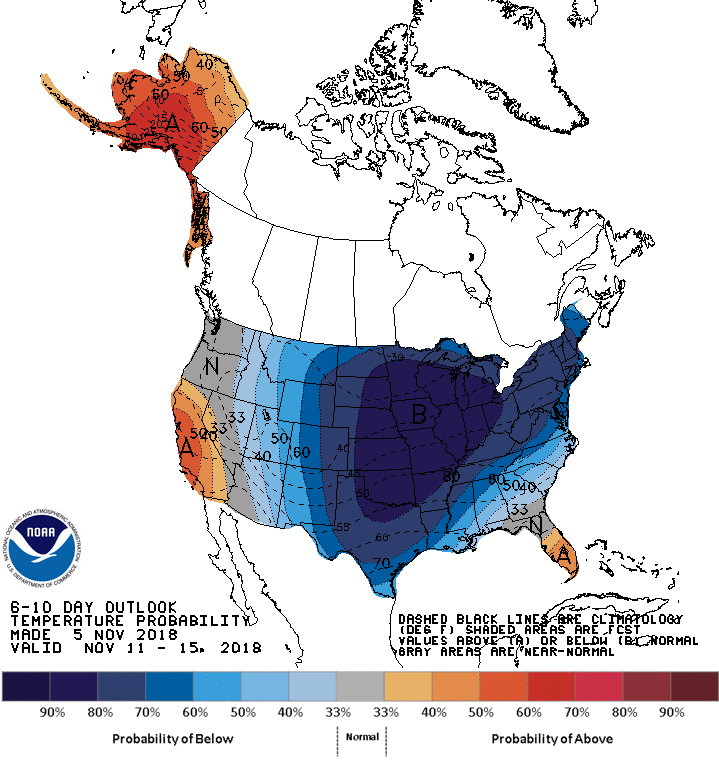
Going forward a much colder pattern reminiscent of December will settle in for the 6-10 day period. The Climate Prediction Center shows this for temperatures.
The 500 mb jet stream flow shows a deep cold trough centered on the Midwest.

The temperature departures at 5,000 feet are dramatic, nearly 22 degrees F. below normal.

Readings that cold will certainly support snow. The question is how do models resolve the energy that ripples through the jet late week. At this point there does not appear to be any meaningful surface storm or large scale disturbance to focus on. However, there is some consistency in 2 clipper like systems Thursday and Friday
The first cuts across the southern half of the Midwest Thursday night. It has the potential of producing up to an inch in spots. The second comes Friday afternoon and it has better upper air support. However, it's narrow and travels NW to SE across Iowa before weakening. This impulse could squeeze out some 1-2" totals...perhaps an isolated 3". A small change in track or intensity could dramatically shift or alter amounts. Between the 2 systems the major models are showing this for total accumulations.
The EURO:

A closer perspective.

Here's the GFS with its total accumulations.

It's still a bit too early to get cute with the numbers. However, it does seem many areas will have a crack at picking up 1/2 to 1" of snow by Saturday. Some local spots (to be named later) 1-2". If this seems early for accumulating snow it is. The first 1" of snow in Cedar Rapids typically does not fall until December 2nd. We'll keep tabs on the snow in coming days but one thing is certain, near record cold is a possibility at some point in the day 4-8 period, especially if we get some snow down. Roll weather...TS


