


DREAM OR REALITY?
- Dec 23, 2018
- 2 min read
Colder air has moved back into the Midwest after nearly two weeks of above normal, mild temperatures. Check this out: temperatures have been 5 to 10 degrees above average across much of the Upper Midwest over the last seven days -

Due to the mild air, snow cover has melted away and not much has fallen lately. Here's the latest snow depth as of Saturday morning -

Now temperatures have been closer to average the last two days due to colder air moving in and cloud cover. Now that cold air will open the doors for systems to produce snow. And there are a few systems on deck to move into the Midwest. The first of which arrives on Christmas. There is still a lot of disparity with this one so let's walk through the possibilities.
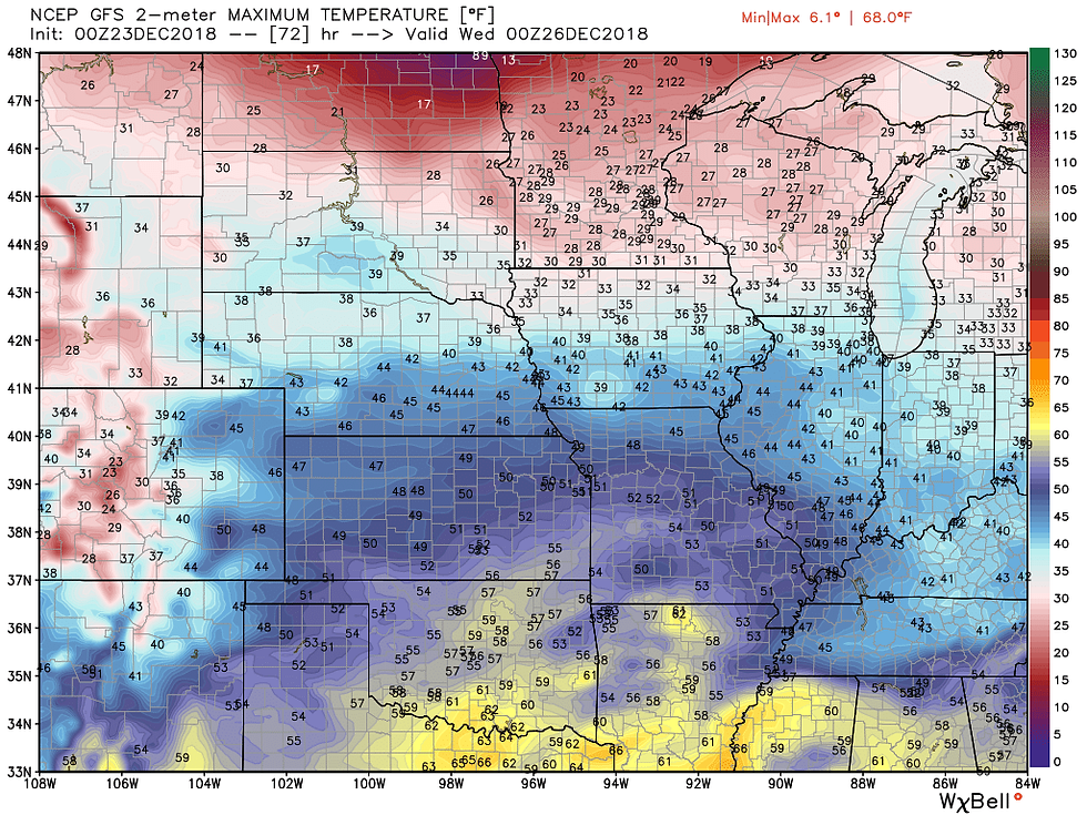
The GFS solution:

The latest run has more moisture to it and moves through in the morning. Highest chances for some wet snow would be near and north of Highway 20. A mix to rain down in the south. Minor accumulations (up to an inch and a half).
The European:

Pretty similar to the GFS, but the colder air is further south. Minor accumulation (up to an inch in Iowa, higher amounts in Wisconsin of around 3").
The NAM:

The most bullish of them all, but having problems with precipitation type (which is fairly typical of the model). Cold air in the upper levels is much further south, but the freezing line is riding along Highway 30. NAM is bringing in much more moisture and showing accumulations of around 1-2" of snow across much of Iowa, into southern Wisconsin and northern Illinois.
The hi-resolution NAM:

Very similar to the NAM solution. This is the end of the run, but would likely produce around the same snowfall amounts of 1-2".
All the models do agree that temperatures will be around or just above freezing while this disturbance comes through. So, it may take some time for accumulation to happen and accumulation will be most likely in the north where the colder air will be.
The GFS and European move the system through fairly quickly in the morning, while the NAM lingers into the early afternoon. Evening Christmas travel looks calm, but early in the morning there could be some slickness on the roads.
Temperatures should climb about freezing in the afternoon on Christmas Day so anything that does accumulate may just melt later in the day.
It's still a question of how far south the cold air gets, how much moisture there is, and how fast the system moves through. That will determine if a white Christmas will be a reality or just a dream in parts of the Midwest...
One more note: If you're traveling Sunday or Monday the weather is looking mighty fine! No travel worries prior to Christmas Day.
RK


Comments