A CHALLENGING STORM ON THE WAY...
We are entering the peak of the severe weather season here in the Midwest. On average, the next 4 weeks are the most active of the year as warmth and moisture reaches the central U.S. on a more consistent basis.

This year has been especially quiet around my area without the issuance of a single tornado or thunderstorm watch through May 6th. Not one tornado warning has been issued for the state of Iowa which is quite unusual this deep into the season.
The primary reason for the slow start here is the absence of instability. We've had a few warm days but none with the deep moisture necessary to kick up strong storms. That's not been the case across the south where tornado numbers are flourishing. In fact, for the nation as a whole the current count of 456 twisters is in the top 70 percent of normal.

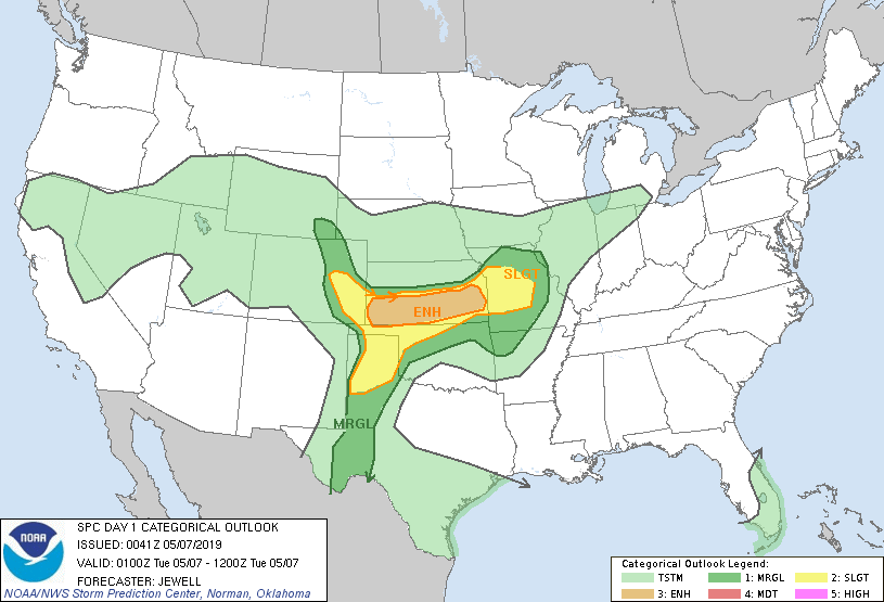
The numbers are likely to go up too as more severe weather is anticipated as a seasonally strong storm cuts across the Midwest. The Storm Prediction Center currently has these outlooks for the potential of tornadoes and severe storms.
Monday night

Tuesday

Wednesday

Thursday

For the central Midwest the day to watch for anything robust convectively is Wednesday afternoon or evening. The EURO has a surface low lifting into central Iowa with an attendant warm front. It separates highs in the 70s and dew points in the 60s to much cooler air in the 40s and 50s to the north. Shear looks significant and instability sufficient for a few strong storms to develop along the warm front and near the triple point later in the day. SPC may need to amend their Wednesday outlook further north to account for this trend which other models are latching onto.

There's also been a lot of talk the past few days of more heavy rain and that comes into play Tuesday night and Wednesday as forcing returns to the area and the low level jet comes back into play. Most models indicate the potential for 1-2" during that period.
The GFS

The NAM

The 3k NAM

The EURO

Temperatures will be tricky (especially Wednesday when a large spread of 20 degrees plus is possible in my area. Beyond Wednesday a significant cool-down emerges for the remainder of the week with highs holding in the 50s.
A busy couple of days ahead with some challenging elements to diagnose. Stay tuned and roll weather...TS


