SUMMER STARTS WITH A BANG?
As I gaze at the thermometer in my office Wednesday evening I'm disheartened by the fact it reads 64 degrees. That's more typical of October. All we are missing are the fall colors! These cool readings are part of a pattern that's been in place since last June. Below you can see how temperatures rank over the past 12 months going back 127 years. 1 is the hottest, 127 the coldest. Most of my area ranks in the top 4-8 coldest years since 1893.

One contributing factor has been precipitation and its associated cloud cover. Look how much of the Midwest is experiencing its wettest period stretching from June 1st 2018 to May 31st 2019.

Rainfall the past 7 days has been spotty over my area. Some heavy amounts up to 2" were measured but they stand in stark contrast to other totals which were less than 1/3 of an inch.

Now the pattern is set to turn active going into the weekend. After an improved day Thursday a strong but slow moving trough will advance on the Midwest. Here it is Saturday at 500mb on the EURO control.

It draws deep tropical moisture into the Midwest as evidenced by PWAT values over 2" into eastern Iowa Saturday.

Dew points Saturday have gone over 70.

Highs are pushing 90 all the way to the southern Iowa border.

The heat and moisture will create significant instability which should foster some vigorous convection. Here's the CAPE values Saturday evening showing the unstable air across the central Midwest.

As it stands now, thunderstorm chances in my area should get cranking Friday night as the warm humid air arrives in my local area. The latest guidance is in poor agreement on timing, intensity, and coverage of overnight storms but I like what the EURO does bringing a mature MCS across my area. Here it is around midnight.

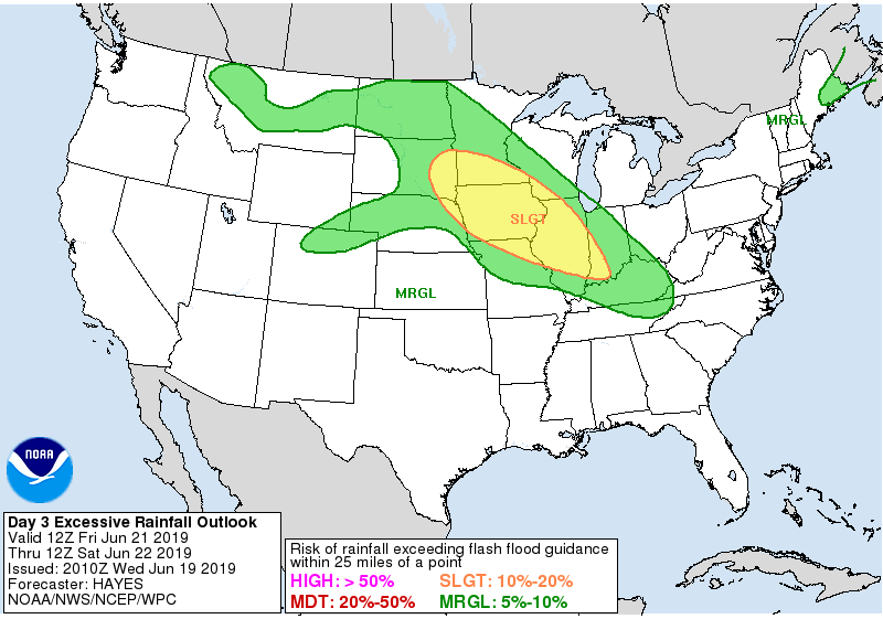
This would likely be the first of several thunderstorm complexes that cross the Midwest through Sunday. There will be lots of dry hours but when and where it rains heavy totals are a near certainty with the high moisture and instability levels that exist. The Weather Prediction Center has this area highlighted for excessive rainfall Friday night.

This is what the EURO has for total rainfall the next 5 days.

Here's a regional perspective.

The Storm Prediction Center has this area outlined for strong storm potential Friday.

Most likely additional parts of my area will be highlighted Saturday and Sunday once mesoscale details become better defined.
All things considered, it looks like an active weekend ahead of us. And we can officially say hello to summer which starts at 10:54 Friday morning. Then the days start getting shorter! Sorry, I couldn't resist. Roll snow and weather...TS


