


THE "BLOB" SIGNALS A COLD WINTER AHEAD...
- terryswails1
- Nov 2, 2019
- 3 min read

Guys and gals, I'm still asking for your help to allow TSwails to grow into one of the best, most unique and reliable weather sites in the Midwest. We hope you will consider a voluntary subscription fee of $12 dollars a year, $1 dollar a month. It allows me to stay free of the corporate world and do what I do best. We hope you can see the value and hard work that goes into the site everyday. Your support in any way is tremendously appreciated. Thanks and roll weather. To donate click on the secure green box below.

SATURDAY'S FEATURED POST
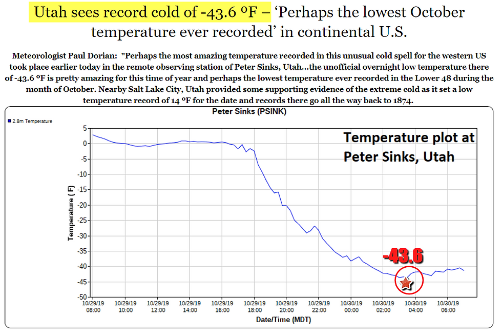
With everything that's been going on around here the past few days something happened in Utah that deserves a mention. The low temperature at a notoriously cold place called Peter Sink dropped to 43.6 below zero. Yea, minus 43.6 in October. That is the coldest temperature ever recorded in the continental U.S. during the month.
Right here in my backyard we dropped to 17 Friday morning and over in Dubuque it was a record breaking 13 degrees. That's after 6" of snow fell there Halloween. Monticello, Iowa was actually the cold spot with a reading of 12. Quite a way to start November.

Just look how much of the country has already seen snow through Halloween.
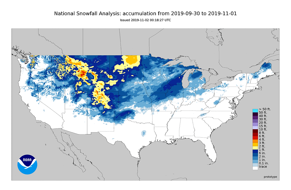
My guy in Lowden, Iowa (Steve Gottschalk) reports 11 inches of snow through today and he's been an NWS observer for 35 years. That's more snow than the average for any month of the winter. So what's causing the early taste of winter? I personally think its the sea surface temperatures, especially on the Pacific, a quiet sun (the lowest number of sunspots in over 100 years), and the westerly phase of the QBO (Quasi-Bienial Oscillation). The QBO is relevant for seasonal prediction when stratospheric winds affects interactions between the tropics and the mid-latitudes. It can also affect how the solar cycle interacts with the atmosphere.
All of that said, I think the primary driver is the water temperatures of the north Pacific. I've mentioned on a number of occasions how the above normal temperatures there initiate the development of a strong upper level ridge off the Pacific northwest coast during winter. That in turn forces cold air into the Midwest on a regular basis. The EPO (eastern Pacific Oscillation) trends negative and the PNA (Pacific North America Oscillation) positive for prolonged periods of time. There are breaks but in general. more cold than seasonal or mild periods.
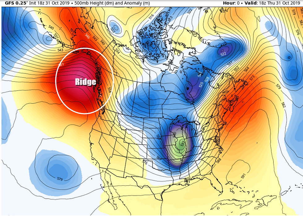
Here's that ridge currently in action out west at the jet stream level of 500mb.
In long range forecasting, it's helpful to use analogs to make seasonal predictions and one year that really shows similarities to this year is 2013. This is what the SST anomalies looked like at this time that year compared to now. Focus on the red blobs in the north Pacific near Alaska.

The winter of 2013-14 was a long cold snowy one over the Midwest and Great Lakes. Chicago had its 3rd snowiest and coldest winter of record. I'm not saying anything like that is going to happen this winter but it is in line with my thinking of a colder than average winter with near to above normal snowfall.
Joe D'Aleo, a meteorologist I respect did a comparison of winters where warm blobs prevailed in the NE Pacific going back to 1895. He found average winter temperature departures that looked like this.

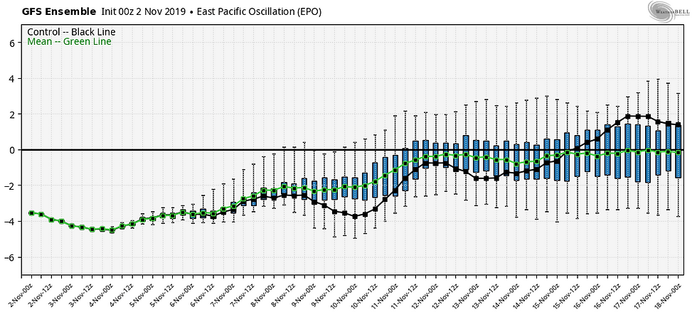
The last thing I will touch upon is something I mentioned last night and that is the tendency for the EPO on the EURO ensembles to go positive by the middle of the month. See the trend here.
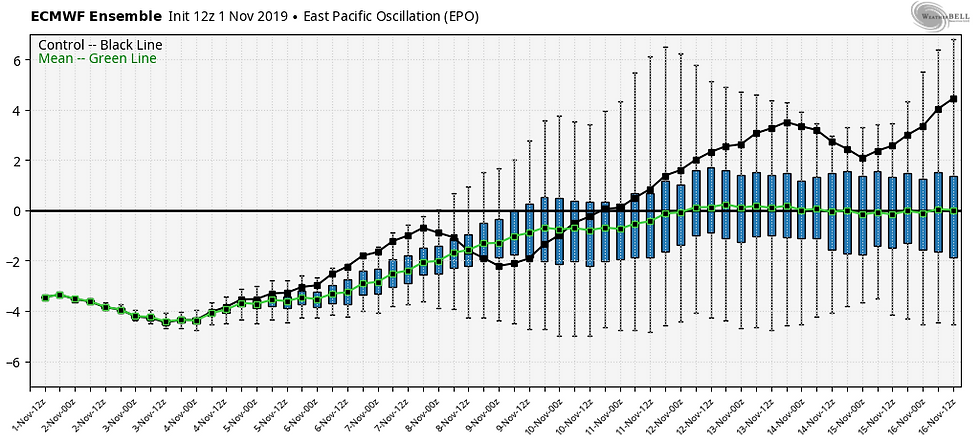
That's a dramatic reversal from where we are now and would signal a period of near to even above normal temperatures by November 15th. However, the GFS ensemble is slower and less amplified, in other words not as mild and slower getting there.
With all this uncertainty it's pretty tough to know how this plays out. Even if the GFS goes the way of the EURO it's possible the pattern change and warm-up would not last long, but you never know. It is however something to hope for after another very chilly week coming up. Roll weather...TS


Comments