SOUTHERN TREND HOLDS...
- Feb 23, 2020
- 1 min read
Winter Storm Watches were put out and will likely be different by Monday morning. The storm has shifted to the southeast - a big jog from earlier trends that had been holding for several days. BUT the trend is your friend and the southern shift continues on the models as of Sunday evening. Now, there will likely be some changes still as the storm comes together, but this is what we have to work with right now.
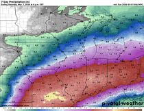
This is a look at the storm Monday through Thursday morning... quite the difference from what we were looking at just last night. The storm is displaced further south and east.

Basically this is an issue of phasing - two storms (low pressure systems) coming together to produce one, stronger storm. The models can sometimes have a difficult time figuring out how the storms come together and the exact track. The European started to catch onto this trend on Sunday afternoon to show the southern shift. And that shift has continued into later model runs and has shown up on other models, ensembles...
Here's the latest European output:

Then the NAM:

Canadian:

The current OUTLIER, GFS:

I also want to show you the GFS ensemble... this is a collection of 50 or so runs of the GFS and then averages them together. The output is definitely further south than the deterministic run...

Bottom line is:
The bulk of the snow is likely going to fall near and east of the Mississippi.
There will likely still be changes.
Big snow will fall somewhere in the Midwest.
We will likely see a change to the "Winter Storm Watches" and see upgrades to warnings.
RK


Comments