


LONG LIVE THE KING, THE EURO RULES...
- Feb 24, 2020
- 2 min read
PLEASE JOIN US FOR A BRAND NEW EDITION OF WEATHER SCHOOL: SEVERE WEATHER 101

We have a brand new weather school planned for April 4th. This one is called Severe Storms 101. If you want to know more about the ins and outs of severe thunderstorms and how to forecast them this will be a great introductory session. There will be event simulations and a big focus on tornadoes. Some tips on chasing them as well. Aside from that there will be in depth focus on the 1968 EF5 Charles City tornado outbreak, the Parkersburg EF5 of 2008, and the rare mid-November EF4 Washington, Illinois twister that occurred November 17, 2013. Lots of compelling video and insights presented by 3 meteorologists. Contact Carolynswettstone@yahoo.com to sign up or click on the more details button in the graphic above to find out more!
The new EURO is in the house and all I can say is long live the king. The EURO rules!!! While we still have a bit of fine tuning to do, it has led with a steady hand and guided its people to the promised land.

This run continues to cut accumulations as the model is seeing and feeling the dry air that's getting pulled into the center. That's forcing the system south which each successive run and even Chicago is now seeing lower projections on amounts.
In the Quad Cities amounts went down another inch and this run shows only 1/2" in the north metro cities of Davenport and Bettendorf. Southeast of the QCA my counties here could see 1-3", perhaps 4" from Macomb to Kewanee...that's assuming the storm does not shift anymore to the southeast which I can't rule out.
Short term there will be some occasional rain roughly south of a line from Muscatine to the Quad Cities and on to near Sterling Rock Falls. Thermal profiles and precipitation do not conspire to generate any snow until Tuesday according to the latest guidance. Most of the accumulations that take place from extreme SE Iowa and into Illinois do not occur until Tuesday afternoon and night.
The NWS is still showing significant accumulations where there is little support for it in my opinion

Same thing for the winter storm watches which remain in effect.
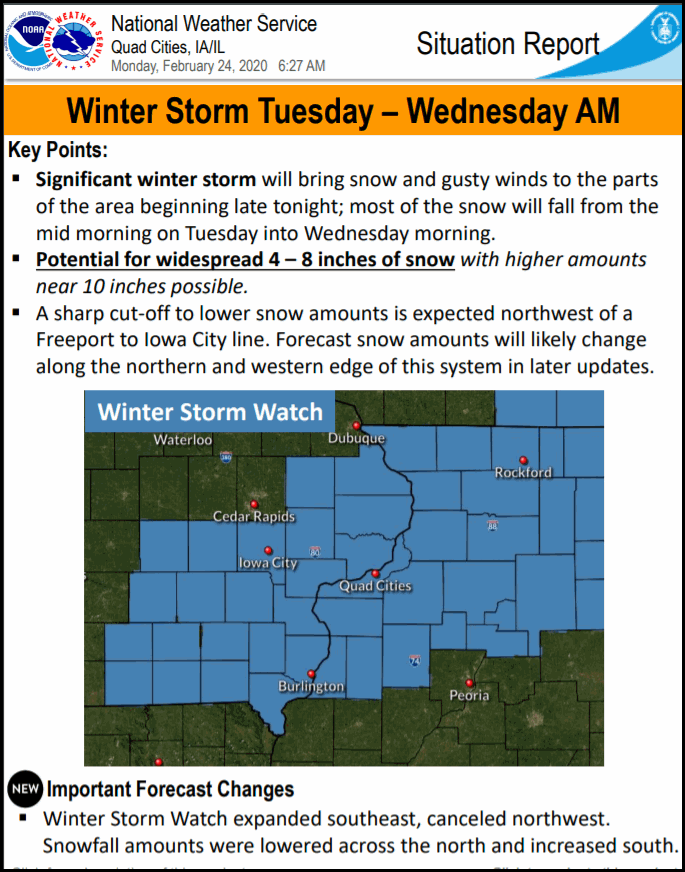
I think its safe to say those are no longer needed or correct. I am anticipating wholesale changes at some point today. In the end, the impacts will be far from what they could have been but that's something I've been touting since Sunday thanks to EURO and some degree the Canadian GEM. The U.S. models once again left much to be desired in their performance. Tha
One last thing to show you. It's the new 12K NAM just in vs the previous run 6 hours ago. The current is on the left the older version on the right. Now the amounts are pretty close to what the EURO is showing, especially in the Quad Cities where its down from 2-4" to less than 1 inch

Time to put a fork in it. It's done unless you are in the far southeastern parts of my area! Roll weather...TS


Comments