


TO SNOW OR NOT TO SNOW...THAT IS THE QUESTION?
- Feb 24, 2020
- 3 min read
PLEASE JOIN US FOR AN ALL NEW EDITION OF WEATHER SCHOOL: SEVERE STORMS 101

We have a brand new weather school planned for April 4th. This one is called Severe Storms 101. If you want to know more about the ins and outs of severe thunderstorms and how to forecast them this will be a great introductory session. There will be event simulations and a big focus on tornadoes. Some tips on chasing them as well. Aside from that there will be in depth focus on the 1968 EF5 Charles City tornado outbreak, the Parkersburg EF5 of 2008, and the rare mid-November EF4 Washington, Illinois twister that occurred November 17, 2013. Lots of compelling video and insights presented by 3 meteorologists. Contact Carolynswettstone@yahoo.com to sign up or click on the more details button in the graphic above to find out more!
TO SNOW OR NOT TO SNOW, THAT IS THE QUESTION?
Not long ago the latest EURO came in and it continues the trend it started 36 hours ago of decreasing the coverage and amounts of snow from the winter storm that is expected to develop over parts of the Midwest Tuesday. Here is what it shows for snowfall totals...hot off the press. Even in my southeastern counties in Illinois amounts are now down to 2-4" at the worst.

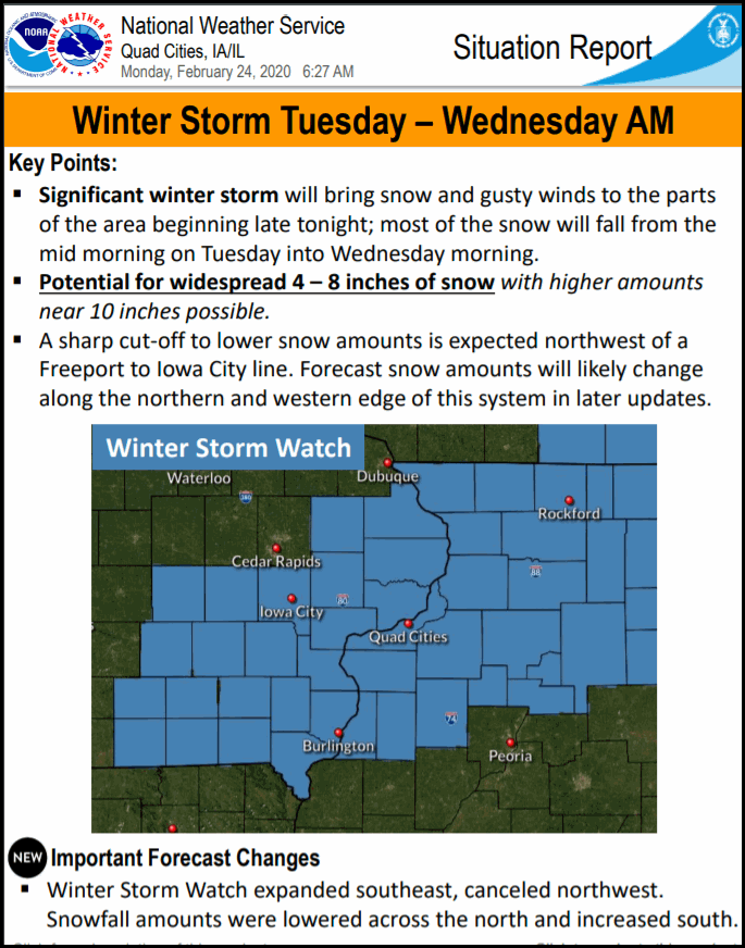
Now it's just one model but it's a good one (the best in my opinion). Needless to say, if this is the correct trend wholesale changes will need to be made in the current forecast from the NWS. This is what they are currently advertising.

These are the odds they have posted of 6 or more inches.

Winter storm watches cover all of these counties in blue for the potential of 4-10" accumulations.
The winter storm severity index shows moderate to even severe impacts over some parts of the region.

SO WHAT DOES IT ALL MEAN?
As you know I've been saying since Sunday morning that if the EURO was right there were big problems in the forecast with this storm performing at the level its currently projected to in my area. In fact, this just came in and on the left you can see the new snowfall forecast of the 12K NAM vs the previous run just 6 hours ago. In the Quad Cities the snow total went from 9.7" in Davenport to 2.8". That's starting to look very much like the EURO.

It's my belief that this is trending the way of the EURO and in the end much of my area in Iowa will see little if any in the way of snow ( I've been expecting that), I also think amounts are now likely to be lower even into Illinois where the worst case totals would not likely be much more than 4"....although you won't have to go very far east or south to find a whole lot more.
I think the winter storm watches will be dropped in eastern Iowa and aside from areas near the Mississippi won't even be replaced with advisories. None of those 4-10" totals shown above on the NWS graphic will verify. As for Illinois, I would run with winter weather advisories for much of my eastern counties.where amounts of 2-5" still seem possible. There could be some spots near Kewanee and Princeton that get into warning criteria close to 6".
Needless to say, this is a fluid situation and I could be wrong....but my confidence is growing the worst of this stays east of my area, and most of the accumulating snow that falls will be in Illinois, especially from the Quad Cities east and south. Right now I like 1-2" in the QCA...worst case 3". New runs in on the EURO early this afternoon. I will have an update for you then. Roll weather...TS


Comments