


THE STEAM IS ON THIS WEEKEND...
- Jul 16, 2020
- 2 min read
Yesterday in my post we discussed summer rainfall and how it can vary dramatically over short distances. Something else that's unique to the season is the amount of rain that can fall in a short period of time. With the warmer temperatures of summer the atmosphere can contain more moisture, which when released under the proper conditions, can produce torrential downpours. In these graphics from the Iowa Mesonet you can see the top 10 rainfall totals over a 1 hour period for some select cities in my area. Notice the majority of these events occurred during the summer months of June, July, and August.


The past 24 hours the heavy rains of 1-2" per hour have occurred over my far southern counties extending into Missouri and Illinois. As we had hoped yesterday, some of the heaviest rains have fallen in central Illinois where it was desperately needed. Here again are the rainfall deficits accumulated since June 1st ending July 13th.

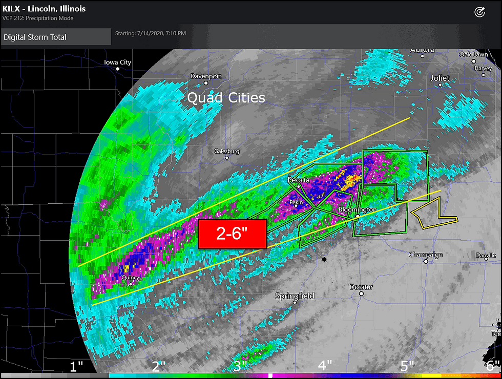
You've all heard the saying too much of a good thing. Here are the Doppler rainfall estimates for Wednesday. Some of those 2-3" deficits southeast of the Quad Cities have been entirely eliminated and turned into surpluses of 2-3", especially around Peoria and Bloomington. In Morton 7.5" fell in a few hours time, and in east Peoria 7" was measured. Severe flash flooding was reported.
Following the disturbance rain chances look pretty minimal until Friday night or early Saturday when some intense warm advection punches into the central Midwest. This is also the leading edge of some very warm and muggy air that will send heat index values Saturday into the range of 100-106 over all of my area. Friday and Sunday will be less extreme and more focused on the south where values of 96-102 are possible. These are the numbers the EURO is presenting Friday, Saturday, and Sunday.
Friday Head Index

Saturday Heat Index

Sunday Heat Index

I think the heat and humidity will ease to more reasonable levels early next week but the central Midwest remains on the periphery of the heat and that implies the potential is there for occasional showers and thunderstorms, some of which will likely be strong with the ability to produce heavy rain.
If nothing else, Thursday should prove to be a pleasant and typical July day with seasonal highs and lower humidity. Throw in some sunshine and you have yourself a day where the weather is definitely on the friendly side. Enjoy it while it lasts and of course, roll weather...TS


Comments