


THE HEAT IS ON, STRONG STORMS TO FOLLOW...
- Jul 18, 2020
- 3 min read
Over the past 24 hours winds have returned to the southwest allowing moisture and very warm air to make a move on the central Midwest. Make no mistake about it, Saturday is going to be a burner! Here's the surface pattern Friday night showing the set-up for the heat.

Notice how the return flow has allowed dew points to climb 10-23 degrees over the past 24 hours from the Plains into Iowa

Temperatures are lagging a bit behind the moisture but they too are increasing. This is the 24 hour change. We'll add another 5 or 6 degrees to these numbers Saturday.

Even with highs only n the 80s to near 90 Friday, the heat index reached 106 from Sioux City through Des Moines and on to Ottumwa.

Saturday water vapor will increase even more as PWAT's approach 2.00 inches by mid-afternoon.

Those values are 1.5 to 2 times greater than normal from my area though the upper Midwest.

That water vapor combined with high evapotranspiration from maturing crops will allow dew points Saturday that peak in the upper 70s to near 80. The 3k NAM shows this.

It's likely that heat index values hit at least 105 and in some areas could push 110. The 3k NAM shows this for heat index values mid to late afternoon. It has 112 in Muscatine (just for you John-boy) and 109 in the Quad Cities.

Most of the Midwest is under a heat advisory with some parts of NW Iowa under an excessive heat watch.

The NWS out of the Quad Cities put this situation report out for highs and heat indices.

The very good news is that this round of heat will be short lived as a cold front forces it back to the south Sunday. The bad news is that ahead of the cold front instability will be massive. The 3k NAM shows CAPE way over 4,000 j/kg Saturday evening.

That is massive fuel that will likely fire strong to severe thunderstorms. SPC has a slight risk outlook for my northern counties but I think this could be enhanced and further south, especially if the convective models are correct in their interpretation of a southeast moving squall line overnight. On paper it has the look of a bowing structure that could produce widespread strong winds as it blasts through the region.

The 3k NAM shows this for composite reflectivity in 3 stages Saturday night. First, the storms approaching my northernmost counties around 10pm.

By 2am the line is racing through the NW half of my area.
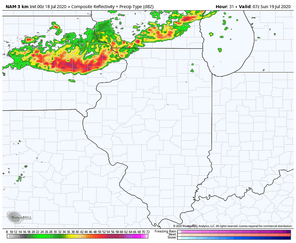
Finally by 5:00am the storms are exiting my southeastern counties and showing signs of weakening.

The bottom line is that following a sizzling day, the overnight hours could see strong thunderstorms as the cap breaks and the instability is tapped. This will be worth watching as the day unfolds.
That leaves all the region with much better weather Sunday. Temperatures and dew points will both be down at least 10 degrees making for a pleasant change.
Unfortunately the heat and humidity will flirt with the area much of next week meaning chances for thunderstorms will return along with muggy conditions. The pattern also looks to have the potential for widespread and what could be heavy rains.The GFS has this for total precipitation the next 2 weeks.

With that in mind I end this post keeping in mind that Saturday should be a day of extreme weather around the region. I'll be watching developments as Saturday unfolds. Keep your cool and roll weather...TS


Comments