


A BREAK FROM THE RING OF FIRE IS COMING
- 3 hours ago
- 3 min read

This was certainly one of the more telegraphed starts to a July I can remember. Looking through my post from last weekend, it's actually quite remarkable how well the forecast went overall, with a return to active weather locally Thursday, flooding along area rivers on the holiday weekend and localized severe weather as well
Estimated rainfall totals across much of Iowa and northern Illinois exceed 3-4" in many locations, but of course there were some of those that missed the action as well. Moline, the official reporting site for the Quad Cities for example, only picked up 0.79" in the first four days of July. However, Davenport was ALL THE WAY up to 3.46"
Dubuque tallied 1.71" with Cedar Rapids coming in with a cool 1.24".

Sunday, there may be a few light showers in the area here and there. The HREF shows a few spotty showers in some of the members. Given some low-level instability, there actually might be a funnel cloud spotted with some of the strongest showers as well, although there's no real threat of damaging tornadoes.

The 'Ring of Fire' pattern, the persistent daytime heat with active storm track overhead, likely takes a bit of a break this week into next weekend. Temperatures will be warm, however increasing northwest flow by late week and into the weekend may actually bring some more comfortable air into the region. Notice the lows for example Tuesday and Wednesday aren't outrageous despite the warm mid-80s for highs. There's really just one trouble spot I am watching in the coming days, and that looks like the Wednesday/Thursday timeframe.
The GFS

The Euro

Both operational global models are indicating some storm threat with a cold front, although timing of this front is questionable. The GFS for example is faster and has more of a Wednesday night threat while the Euro is slower and is more of a daytime Thursday threat. The potential of severe weather would rely on the timing of this front passing through the area.

Overall looking at the European Ensemble, they seem more aligned with a Thursday daytime timing through our area. At this point it does not look like a significant threat, and it's rather progressive meaning the threat is lingering heavy rain is quite limited. This looks more like a refreshing front bringing in some cooler air for next weekend - relatively speaking for July of course - with northwest flow bringing in direr air to the region.

For the first time in a while, analogs are indicating a widespread area of below-normal precipitation across the region as northwest flow takes over thanks to a ridge building over the Rockies. This will bring in the Monsoon Season to areas like Arizona and Utah which could desperately use the rain to fight widespread wildfires. Overall much of the country could use this break and pattern change. The one problem will be the Northern Rockies, and Colorado, which will see a sharp increase in temperatures which will challenge their wildfires.

This transition to northwest flow pattern may actually lock in for quite some time. The European Ensemble has this change in pattern sticking around through at least July 20, with no real change in sight in the long range. The recent heavy rain was very important as it looks like the active pattern shuts down.
The GEFS
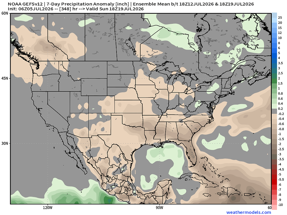
The EPS

The long range ensemble forecasts on the EPS and the GEFS all show a notable dryness across the Upper Midwest. Ideally the rcent heavy rains will help hold off any drought development, but a prolonged stretch of dry weather during some of the hottest temperatures of the year could be a problem. This we will need to watch closely.
Hope everyone had a wonderful Fourth of July!
-Meteorologist Nick Stewart


Comments