


A CHANGE OF SEASONS...
- Aug 21, 2025
- 3 min read
If you're looking for a change in the weather, your time has come. We've already experienced a reduction in temperatures and humidity that will be significantly enhanced by a much stronger front that clears the region Friday night. This one should get your full attention as it brings lows in the 40s, (the coldest temperatures since back in May). The early fall conditions should be around through the end of the month. In the Quad Cities, the GFS indicates highs like this through the 31st. Not a day higher than 81 with 4 days shown in 60s. It also has 3 morning lows in the 40s, pretty impressive for August.

The impetus for this radical reversal in fortunes is the development of a sizable trough over the east that converts upper level winds into what's known as NW flow. You can watch the process unfold in this 500mb animation that ends Tuesday.

By way of temperature departures, you can see the cool air is well established over the Midwest Monday morning.

That translates to morning lows Monday on the GFS that range from 44 to 48 from north to south. That would challenge record lows for the date, should it verify. The EURO is several degrees warmer.

After the cold start, these are the highs shown on the GFS later Monday afternoon. That is crispy fresh.

These are the 7-day average temperature departures (per day) for the week long period August 23rd to the 31st. Open the windows and give that air conditioner a well-earned break!

The other key change that results with this pattern is far less precipitation. The NW flow restricts our moisture source, which is the Gulf of Mexico. Next Tuesday morning, available water vapor is under 1/2 inch. The last few weeks it's been more in the range of 1.50 to 2.25 inches.

Tuesday morning, precipitable water vapor is only 30-40% of normal, instead of 200% above normal in recent weeks. In the brown colors, you can see the extent of the dry air over the central and eastern U.S. next Tuesday.

These are the negative precipitation departures the GFS is indicating over the next 2 weeks.
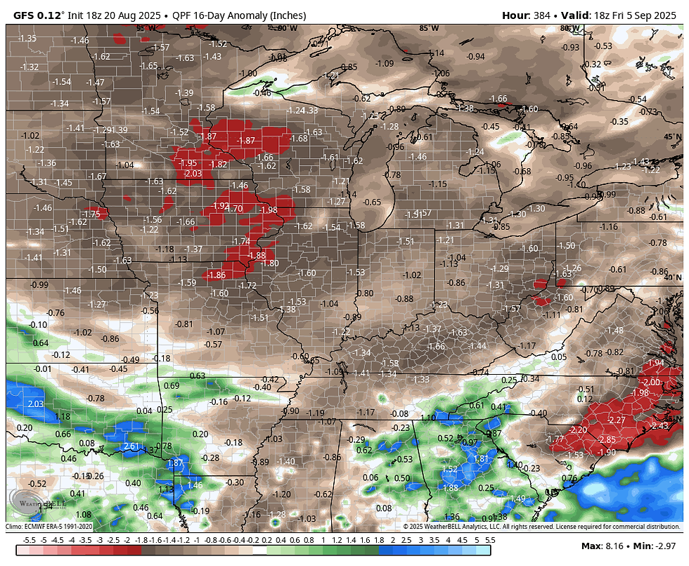
Here you can see the actual totals the GFS depicts over that 2-week period ending September 5th. That's peanuts compared to the 3-5 inch amounts that have been regularly showing the past month.

The National Blend of Models shows this for total amounts over the period ending September 1st, lending high confidence to the dryness of the coming pattern.

Outside a few scattered light showers Friday night and again in the north later Sunday, that's about it for rain chances through next week. Cool and collected conditions are certainly on the table.

I will be off the next couple of days to attend the funeral of my mother Rose Swails, Meteorologist Nick Stewart will kindly take my place. Mom was 95 and a real looker in her day. She was always very humbled to have been chosen the homecoming queen at University High School in Iowa City, where she was also a cheerleader. I asked her what her proudest achievement was, and she told me numerous times it was me and my sister, family was everything growing up. All the love and countless sacrifices made on our behalf is a priceless gift. I'll always remember her generous heart and classic beauty. She will be missed, but in no way forgotten! Terry


You have our deepest sympathy. It is hard to lose a parent, no matter their age. That link to all the history and knowledge of their generation is then gone. Hugs and prayers!
I’m so sorry for your loss. Nothing like losing your momma. My heart is with you and your family