


A FIREBALL...
- Jul 23, 2025
- 4 min read
Make no mistake about, Wednesday has the makings of a fireball, with temperatures in the 90s and dew points in the upper 70s. When you step out of an air-conditioned room into that atmospheric combination, it's like walking straight into a blast furnace. More on that in a fiery story in a second.
First of all, I want you to look at an interesting feature of the Midwest's weather Tuesday. It had its beginnings Monday night when a thunderstorm cluster developed over Nebraska. With time, it pressed east and eventually its rain making ability failed as the storms weakened and dissipated. While the rains and lightning were gone, The heat released by the MCS created a localized area of lower pressure, which began to rotate, creating a spinning area of vorticity (energy). This feature is known as an MCV (mesoscale convective vortex). You can even see the center of circulation on the hi-res visible satellite imagery as it spins into SW Iowa Tuesday morning.

While the energy was rather innocuous as it pressed east during the day, it eventually became the focus for additional thunderstorm development towards evening when instability was maximized. Look at the satellite explode with color as storms spring to life at that time.

Here's what the radar looked around 8:20pm as storms cluster near the vorticity emitted by the MCV.

These discrete events are almost impossible for models to detect until the MCV forms early in the day, and even then they can still struggle mightily with it. That said, the big tip off storms might fire was the satellite animation I first showed you Tuesday morning. The vorticity was evident and that's why as a forecaster, you rely on all the tools in the box, not just the models. A little experience also makes a big difference.
Anyway, at this point Tuesday evening the 3k NAM has caught on to the fact the MCV exists and shows it tracking northeast, impacting NE Iowa and just grazing my NW counties. It depicts this for rainfall by daybreak Wednesday. Some pretty hefty totals of 1–3 inches are indicated from NE Iowa into western Wisconsin. Some reports from Buchanan County, Iowa confirm at least 3 inches of rain have fallen as of 3:00am Wednesday.

IT'S TIME TO VISIT TO MY 5 STAR GALENA AIRBNB

My 5-STAR AIRBNB just outside of Galena still has some openings this summer. All of our ratings are 5 star! We take pride in the amenities and the cleanliness. If you book now, we'll take off $200, and we can eliminate AIRBNB fees and additional costs that will save you big bucks. Other discounts apply. Call or text Carolyn at 563-676-3320 for our best deal of summer. See more at https://www.littlewhitechurchgalena.com/
TURNING TO THE HEAT AHEAD...
All the signs point to any stray storms or debris clouds having moved out of my NW counties by daybreak Wednesday. Behind them, very warm air aloft is shown areawide with 850 temperatures progged to reach 22–24 degrees C. That is extremely warm air, especially at the hottest time of the year. It will bring a stout CAPPING inversion that should bring plenty of sunshine and robust heating.

The HRRR sends highs into the range of 91 to 95 degrees, straight up.

Dew points, enhanced by evapotranspiration and recent heavy rains, are likely to reach at least the mid 70s, maybe a touch more in spots. That along with highs in the 90s should send heat index values into the range of 100 to 105 degrees.

That has prompted the NWS to issue widespread heat advisories for any strenuous outdoor conditions.

From the look of things, significant heat advisories are again possible Thursday, but that is not cut and dried, especially in the NW 2/3rds of my area where an approaching cold front may bring scattered thunderstorms and enough debris clouds to temper the heat, eliminating the need for headlines in that part of my area. That trend seems to be gaining traction.
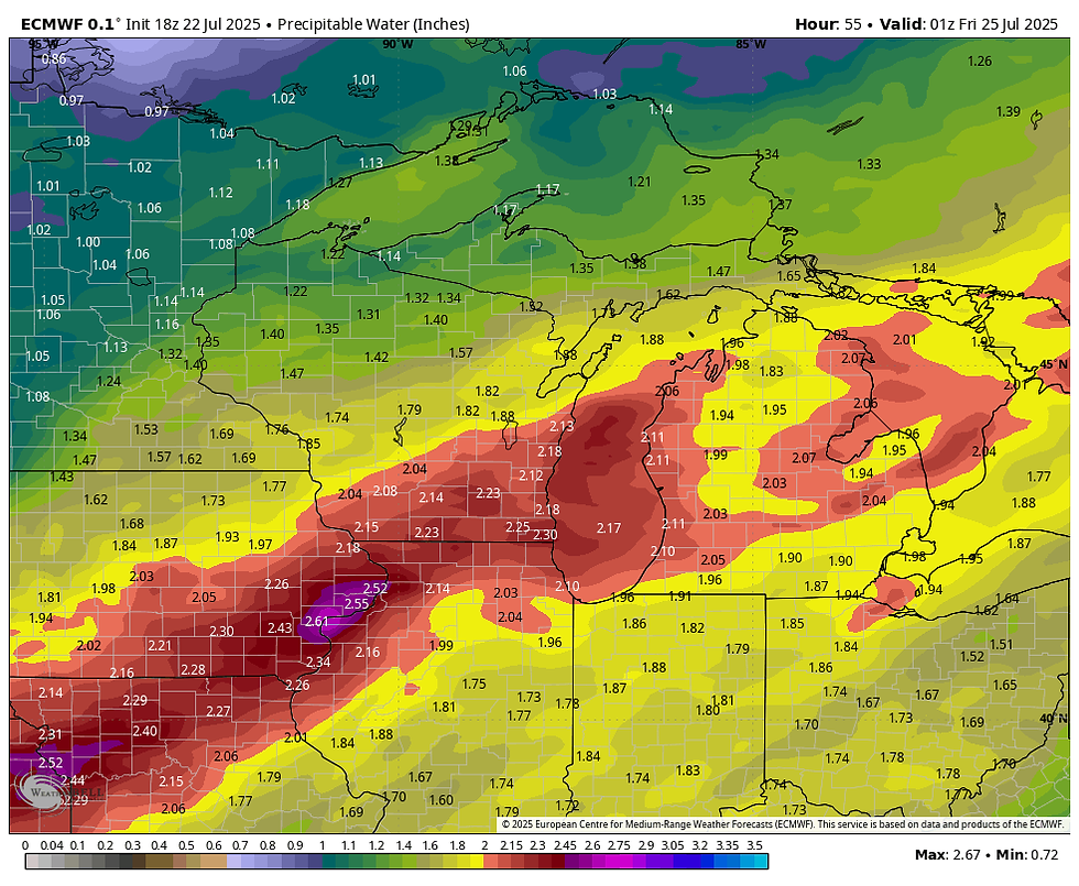
As for thunderstorms Thursday, models are struggling a bit with timing and intensity but in general show a good chance that some will develop if not Thursday afternoon, sometime Thursday night as the front drifts southeast. As has been the case with recent rain events, water vapor is extremely high, with the EURO showing PWATS up to 2.61 inches in southeast Iowa. With warm cloud tops similar to tropical systems, any storms that go up in that environment could be excessive rain producers.
With the front and deep moisture shown wavering around into the weekend, additional thunderstorms are likely with the threat of locally heavy rain in spots. This is another "ring of fire" set up with my region on the nose of a potent heat dome just to the south. Our eventual proximity to that boundary will determine whether some part of the area gets into an excessive rain threat. Mesoscale details that determine the outcome are still unknown, but the early read is that some part of the central Midwest is again in a vulnerable position for flash flooding. Something to watch closely going forward.
If nothing else, temperatures will ease back into the 80s Friday and into the weekend, but we won't be as lucky with humidity as moisture will be plentiful through Monday of next week. Beyond that point, there are signs the heat dome may be displaced further SW allowing a break from the active pattern for at least a 2-3 day period. That would be a good thing.
On that note, I will call it a post. Stay cool and roll weather...TS


Comments